When we started hiking in Europe, we stopped hiking anywhere else. Okay, it’s mostly because of the food. I mean who wouldn’t want a Käse Rösti mid-hike, or a celebratory beach-side seafood linguini at the end of a hike.
Whether you’re hiking in the mountains, along the coast, or in river valleys (vineyard hikes anyone?), Europe hiking trails spoil you with delicious food, fresh dairy, wine, beer, schnapps, and of course romantic scenery. So, our definition of a best hike is one that combines sensational landscapes with culinary rewards. After all, this is Europe.
At this point, our passion for hiking in Europe is an obsession, albeit a healthy one. So, this post outlines our favorite day hikes in Europe to date. We update this post every year.
If you’re interested in multi-day hiking trails, read Best Treks in Europe and 2-Day Hikes in Europe.

- Where to Hike in Europe in Spring: Southern Europe and the Mediterranean: Crete, Portugal, Calanques National Park, Mallorca, Kotor and Brittany (late spring).
- Where to Hike in Europe in Summer: Faroe Islands, Montenegro, the UK and Ireland, Picos de Europa National Park, and The Alps: Swiss Alps, Italian Alps, French Alps, Austrian Alps, Slovenian Alps, and Bavarian Alps
- Where to Hike in Europe in Fall: Southern Europe, the Mediterranean, Central European River Valleys, and the Alps, weather-permitting
- Where to Hike in Europe in Winter: Tenerife, Gran Canaria, and Malta
- Trail Waymarking: In Eastern Europe and in the Balkans, trails are often waymarked with the knafelc blaze (red circle around a white dot). In the Alps, it’s common to see red-white-red painted waymarks on rocks and trees. In Nordic Europe, trails are often marked with cairns (rock stacks).
- Mountain Huts: There is a vast network of mountain huts across Europe. You’ll find the highest concentration of mountain shelters in the Alps (Slovenian huts, Austrian huts), but they exist almost everywhere in the mountains of Europe (High Tatras in Slovakia and Poland, Picos de Europa in Spain, Pyrenees in France and Spain, etc…). There’s nothing better than eating lunch in a managed hut, high up in the mountains.
1. Aradena Gorge Hike, Crete

In the remote region of Sfakia in West Crete, Aradena Gorge runs from the southern slopes of Lefka Ori, or White Mountains, all the way down to the Libyan Sea.
Aradena Gorge descends to Marmara Beach in stages, alternating between flat and steep stretches. Much of the thrill of hiking down the gorge lies in scrambling between boulders and navigating steep scree fields. Waymarks guide hikers through the more difficult passages.
There are numerous ways to hike Aradena Gorge, with options for circular, point-to-point, and out-and-back routes.
Kati and I took a taxi from the seaside village of Chora Sfakion (aka Hora Sfakion and Sfakia) to Aradena Village to commence the hike. We hiked through the gorge to Marmara Beach and then continued all the way back to Chora Sfakion on foot, following the coastal trail (E4). Most hikers will end the hike at Marmara Beach and return to Chora Sfakion with a water taxi.
Read our Aradena Gorge trail guide for a complete description of this unmissable trail.
Trail Stats
Starting Point | Aradena Village
Ending Point | Marmara Beach
Distance | 5.6 point-to-point
Time Needed | 3 hours
Elevation Gain | 100 meters
Elevation Loss | 660 meters
Difficulty | Difficult
Where to Stay in Chora Sfakion | Sofia’s Lovely Rooms (budget), Authentic Village Boutique Hotel (midrange), Panorama New Generation (midrange-luxury)
Recommended Itinerary | 10-Day Crete Road Trip
2. Cassis to Marseille Coastal Trail, France

A spectacular coastal trail links the fishing village of Cassis with France’s second largest city, Marseille, in Calanques National Park. Given park restrictions and the absence of accommodations in the park, the only way to hike from Cassis to Marseille is on a series of day hikes.
Based in Marseille, Kati and I tackled the coastal route in 3 stages using public transit:
Stage 1 | Cassis – Devenson Cliffs – Luminy Hike
Stage 2 | Luminy – Calanque de Sugiton – Calanque de Morgiou – Les Baumettes Hike
Sage 3 | Les Baumettes – Calanque de Sormiou – Les Goudes Hike
Rather than highlight just one of these day hikes, we wanted to share all three, since they are equally magnificent. To plan a similar trip, read our Marseille Calanques Itinerary.
Where to Stay in Marseille | Hôtel Le M (midrange), Les Appartements du Vieux Port (midrange), Boutique Hôtel Provencia (midrange), Hôtel C2 (luxury), or Maisons du Monde Hôtel & Suites (luxury)
Where to Stay in Cassis | Chambre d’hôtes Clos du Petit Jésus (midrange), HPC Suites (luxury), Hotel De La Plage (luxury), or Hôtel Les Roches Blanches (luxury)
3. Olpererhütte Hike, Zillertal Alps, Austria

This gorgeous Europe hiking trail serves up quintessential alpine landscapes filled with scenes of glaciated peaks, alpine pastures, and sparkling teal waters. It’s also a great introduction to mountain hut culture in the Austrian Alps.
Olpererhütte is a mountain hut in the Zillertal Alps in Tirol, Austria. It’s one of the most perfectly situated refuges in the Alps, because it overlooks the Schlegeisspeicher reservoir backed by the arresting Zillertal mountains.
There are a few ways to hike up to Olpererhütte. Like many things in life, the longer and the more difficult the way is the more rewarding the journey. We highly recommend approaching Olpererhütte from Friesenberghaus.
To start this hike, drive or take the bus from Mayrhofen to the Schlegeisspeicher reservoir. From the reservoir, ascend two hours to Friesenberghaus. If needed, take a break at the managed hut and drink a refreshing beverage like Apfelsaft gespritzt or Johannisbeersaft gespritzt (juice mixed with sparkling water).
From Friesenberghaus, the way to Olpererhütte follows the captivating Berlin High Trail, one of the best multi-day hikes in Austria.
The trail steeply ascends 170 meters and then eases into a magnificent traverse.
Shortly before arriving at the hut, you’ll cross a suspension bridge. This small bridge is one of the most coveted photo motifs in Austria.
When you arrive at the beloved Olpererhütte, grab a seat outside on the hut’s terrace. From here, you’ll have unobstructed views of the Schlegeisspeicher reservoir at the foot of 3,000 meter high peaks. There’s no better place to have a slow, indulgent lunch and a glass of wine.
We live in Austria and are passionate about showcasing the country’s many gorgeous hiking regions. If you’re planning a trip to Austria, also check out: Best Day Hikes in Austria, Salzburg Hiking Guide, Innsbruck Hiking Guide, and our Vorarlberg Hiking Guide.
Trail Stats
Trailhead | Schlegeisspeicher reservoir
Distance | 13 km circuit
Time Needed | 7 hours
Difficulty | Moderate – Moderately Difficult
When to Hike | June – October, depending on snow conditions
Recommended Itinerary | 7-Day Austria Road Trip or 10-Day Bavarian & Tyrol Road Trip
Where to Stay in Mayrhofen, Zillertal | Landhotel Rauchenwalderhof (budget), Alpenhotel Kramerwirt (midrange), or ZillergrundRock Luxury Mountain Resort (luxury)
Learn More: Olpererhütte Day Hike
4. Seven Sisters Cliffs Walk, South Downs, England

The Seven Sisters are a series of white chalk cliffs stretching from Cuckmere Haven to Birling Gap in East Sussex, England. Plunging into the English Channel, these shimmering vertical cliffs are best experienced on foot.
The Seven Sisters Cliffs walk starts in Seaford and ends in Eastbourne, hugging the coast almost the entire way.
Most people will visit the Seven Sisters Cliffs as a day trip from either Brighton, or London.
We recommend starting this point-to-point day hike in Seaford. From the Seaford train station, walk directly to the sea and follow the promenade to the eastern end of the beach. From here, locate the coastal trail that enters Seaford Head Nature Reserve. Follow this coastal trail in the direction of Cuckmere Haven.
From Cuckmere Haven, walk inland to Cuckmere Inn and cross the river at the bridge. After the bridge crossing, head back to the coast and follow the South Downs Way to Birling Gap and Beachy Head.
This is easily one of the most spectacular hikes in Europe. Start early and walk slowly, because you’ll want to relish every moment.
Insider Tip: Order cream tea (tea with scones) at the Birling Gap Café.
Trail Stats
Starting Point | Seaford
Ending Point | Eastbourne
Distance | 21.9 km point-to-point
Time Needed | 7 hours
Difficulty | Easy
When to Hike | May – October
Where to Stay in Brighton | Snooze (midrange), The Charm Brighton Boutique Hotel & Spa (midrange), or Hotel Una (luxury)
Where to Stay in Eastbourne | The View Hotel (midrange), Ravilious Hotel (midrange), or The Chatsworth Hotel (luxury)
Learn More: Seven Sisters Cliffs Walk Trail Guide
5. Hoher Kasten – Saxer Lücke – Fälensee Circuit Trail, Alpstein, Switzerland

The Hoher Kasten to Saxer Lücke hike runs along the undulating Eastern Ridge of the Alpstein massif in northeastern Switzerland. This scenic high trail offers spellbinding views of the Rhine Valley as well as the Alpstein mountains.
This Swiss hike, officially called “Geological Trail,” begins with cable car ascent from the village of Brülisau, near Appenzell, to the summit of Hoher Kasten. From the mountain station, this high trail rises and falls along the ridge in the direction of the Staubern mountain inn.
As you journey from the Staubern mountain inn to the Saxer Lücke mountain pass, you’ll be treated to bird’s-eye views of Fälensee, a dreamy lake cradled by a wreath of serrated peaks.
The descent to Saxer Lücke is accompanied by unimaginable views of perspectives of the Kreuzberg mountain chain, a string of eight vertical spires. This is one of the most sought-after “photography” destinations in Switzerland.
The trail descends to Berggasthaus Bollenwees, the mountain inn located on the lakeshore of Fälensee. Don’t leave without ordering Rösti mit Appenzeller Käse, Ei, und Speck (hash browns with cheese, eggs, and bacon).
From this gorgeous mountain lake, the trail continues all the way down to Brülisau Car Park.
While this hike isn’t technically difficult, it’s long and taxing on your knees, because of the long descent.
We recommend staying 3-5 nights in the Appenzell Region in order to hike to Marwees Ridge, Schäfler Ridge, and Aescher Hut. Read our guide to Best Hikes in Appenzell for a complete overview.
Trail Stats
Starting/Ending Point | Brülisau Village, Appenzell Innerrhoden
Trailhead | Hoher Kasten Cable Car mountain station
Distance | 19.3 km circuit
Time Needed | 6 hours
Difficulty | Moderate
When to Hike | June – October
Where to Stay in Appenzell Village | Alte Metzg – Hostel (budget), Blattenheimat (midrange), Hotel B&B Stossplatz (midrange), or Hotel Appenzel (luxury).
Learn More: Hoher Kasten – Saxer Lücke Hiking Guide
6. Seven Hanging Valleys Trail, Algarve, Portugal

Famed for its sunshine and spectacular beaches, Algarve is probably not the first place you think of when dreaming about hiking in Europe. However, if you’re visiting Southern Portugal in Spring, or Fall, coastal hiking should be your number one priority.
One of the most beautiful coastal paths in Algarve stretches between Praia da Marinha to Praia de Vale Centianes. This 5.7 km trail (one-way) can easily be done as an out-and-back hike.
Eat lunch at O Stop on Vale Centianes beach, before returning to Praia da Marinha.
Read Best Coastal Hikes in Portugal for a summary of the most beautiful hikes in Portugal including Sintra Coast Day Hike and the Fisherman’s Trail.
Trail Stats
Trailhead | Praia da Marinha
Destination | Praia de Vale Centianes
Distance | 5.7 km one-way, 11.4 km out-and-back
Time Needed | 2 – 2:30 hours one-way, 5 – 6 hours out-and-back
Difficulty | Easy
When to Hike | Spring (April – May), or Fall (September – November). You can hike here in summer, but start early to avoid the heat.
Recommended Itinerary | 7 Day Algarve Road Trip
Where to Stay in Carvoeiro | O Quintal Guesthouse (budget), O Castelo Guest House (midrange), or Tivoli Carvoeiro Algarve Resort (luxury)
Learn More: Seven Hanging Valleys Trail
7. Tre Cime di Lavaredo Circuit Trail, Sexten Dolomites, Italy

Tre Cime di Lavaredo (Drei Zinnen in German) is the name given to three mammoth peaks in the Sesto/Sexten Dolomites in Northern Italy. These iconic peaks mark the border between German-speaking South Tyrol and Italian-speaking Belluno.
The loop trail around the iconic Tre Cime di Lavaredo in the Italian Dolomites is one of the most jaw-dropping and accessible day hikes in Europe.
The Tre Cime di Lavaredo loop hike starts at the mountain hut Rifugio Auronzo, which is accessible by a toll road. The closest towns to Tre Cime di Lavaredo are Cortina d’Ampezzo and Dobbiaco/Toblach in Alta Pusteria/Pustertal.
From Rifugio Auronzo, we recommend hiking the circuit clockwise. Follow trail 105 in the direction of Langealm.
Though most people venture here to see the Three Peaks, they soon realize that Tre Cime di Lavaredo is just the beginning of an unending visual feast that extends in every possible direction.
Along the circuit, there are a few managed huts which sell food and refreshments. We recommend eating a hearty meal at Drei Zinnen Hütte (Rifugio Locatelli).
After completing the hike, walk from the Rifugio Auronzo car park to the impressive Cadini di Misurina Viewpoint.
Read Best Day Hikes in the Dolomites for a overview of 40+ day hikes in the Dolomites, including hikes in Cortina d’Ampezzo, hikes in Val Gardena, and hikes in Alta Badia.
Trail Stats
Trailhead | Rifugio Auronzo
Distance | 9.7 km circuit
Time Needed | 4 hours
Difficulty | Easy – Moderate
When to Hike | June – October
Recommended Itinerary | 7 Day Dolomites Road Trip or 5 Day Dolomites Itinerary
Where to Stay in Misurina | Quinz – Locanda Al Lago (budget), Chalet Lago Antorno (midrange), or Hotel Miralago (midrange)
Where to Stay in Cortina d’Ampezzo | Jaegerhaus Agriturismo (budget), Camina Suite and Spa (midrange), or Dolomiti Lodge Alverà (luxury)
Learn More: Tre Cime di Lavaredo Day Hike
8. Xlendi Bay to Sanap Cliffs Coastal Trail, Malta
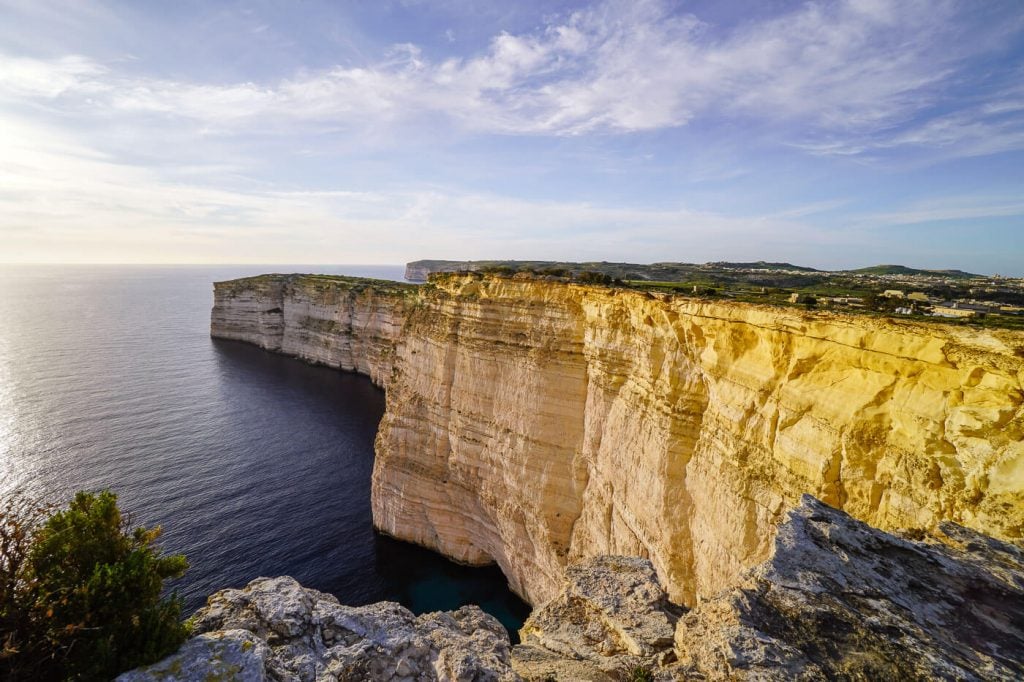
Gozo Island is the second largest island in the Maltese archipelago in the Mediterranean Sea. It’s famous for its cliffed coastline, idyllic coves, and pastoral landscapes.
The island nation of Malta is a fabulous destination for a quick winter sun holiday in Europe. We visited Malta in February and enjoyed brilliant blue skies, moderate temperatures, and peaceful trails.
The out-and-back hike from Xlendi Bay to the Sanap Cliffs is a deliciously, scenic hike which hugs the pristine coastline the whole time. This is one of our absolute favorite coastal hikes in Europe.
To start this day hike, head to the seaside village of Xlendi in the southwest coast of Gozo.
Walk to Xlendi Beach and follow the pedestrian path along the bay. The paver walkway wraps around the bay to an idyllic picnic area with a smattering of benches. After crossing a stone bridge, the trail ascends to the Ras il-Bajda cliffs, home to the historic Xlendi Tower, which dates back to 1650.
Continue south along the high cliffside trail. You’ll pass a sheltered cove and then join another paver walkway, which leads to the Sanap Cliffs.
When the paver walkway ends, continue following the coast all the way to Il-Pinnur Point.
Trail Stats
Trailhead | Xlendi Beach, Gozo Island
Distance | 7.1 km out-and-back
Time Needed | 2:40 hours
Difficulty | Easy
When to Hike | November – May
Where to Stay in Xlendi | San Antonio Guesthouse – Bed & Breakfast (budget), or Viewpoint Boutique Living Xlendi Gozo (midrange-luxury)
Learn More: Best Coastal Hikes in Malta and Gozo
9. Bobotov Kuk Peak Hike, Durmitor National Park, Montenegro

Bobotov Kuk (also spelled Bobotov Kuv) is the highest peak (2,523 m) in Durmitor National Park and a favorite hiking destination in Montenegro. To start this hike in the Dinaric Alps, head to “Sedlo,” the pass on the scenic P14 road, just outside of Žabljak.
After a short secured section, the trail is mostly flat, gently meandering across meadows for 1:30 – 2 hours. The surrounding mountains dazzle with their unique shapes and geological features. It’s like walking through a colossal sculpture gallery.
Soon after passing the small lake Zeleni Vrh, the trail ascends dramatically. The final airy stretch to the summit is partially secured and requires a bit of scrambling.
Trail poles like the Unisex Black Diamond Hiking Pole are very helpful, especially on the descent.
Trail Stats
Trailhead | Sedlo on P14
Distance | 9.9 km out-and-back
Time Needed | 5:30 hours. We needed 6:15 hours with breaks.
Difficulty | Difficult
When to Hike | June – late September/early October
Recommended Itinerary | 2 Week Montenegro Road Trip
Where to Stay in Žabljak | Best Hotels and Accommodations in Žabljak
More Hikes in Montenegro: Bobotov Kuk Trail Guide
10. Roques de García Circuit Trail, Tenerife, Spain

When it comes to hiking in Europe, most hiking destinations are only accessible in the summer. However, there’s a wonderful exception.
If you want to hike in Europe in winter, head to the Canary Islands. We spent one month exploring Tenerife Island from December to January, and we were blown away by the scenic diversity and the trail options.
You can read about our favorite trails in Best Day Hikes in Tenerife.
One particular hike everyone should do is the Roques de García loop trail in Teide National Park.
The park’s main attraction is Mount Teide (3715 m), the highest mountain in Spain. However, the Roques de García rock formation is another attraction worth visiting.
The trail starts at the Mirador de la Ruleta viewpoint, directly across from Parador Nacional, in the Las Cañadas caldera. From the Mirador de la Ruleta lookout point, you’ll see the impressive La Catedral rock jutting out of the Caldera floor. In the background, the caldera rim looks like a wall of stone.
With Mount Teide (Spain’s highest mountain) in full view, the trail loops around these craggy rocks in just over an hour.
During your trip to Tenerife, also check out the Best Hikes in the Anaga Mountains and the Best Hikes in the Teno Mountains.
Trail Stats
Trailhead | Mirador de la Ruleta, Teide National Park
Distance | 4.2 km circuit
Time Needed | 1:30 hours
Difficulty | Easy
When to Hike | November – May
Recommended Itinerary | 7 Day Tenerife Road Trip
Where to Stay | Parador de Las Cañadas del Teide (luxury) in Teide Nationalpark, or El Tejar Hotel & Spa (midrange) in Vilaflor
Learn More: Best Hikes in Teide National Park
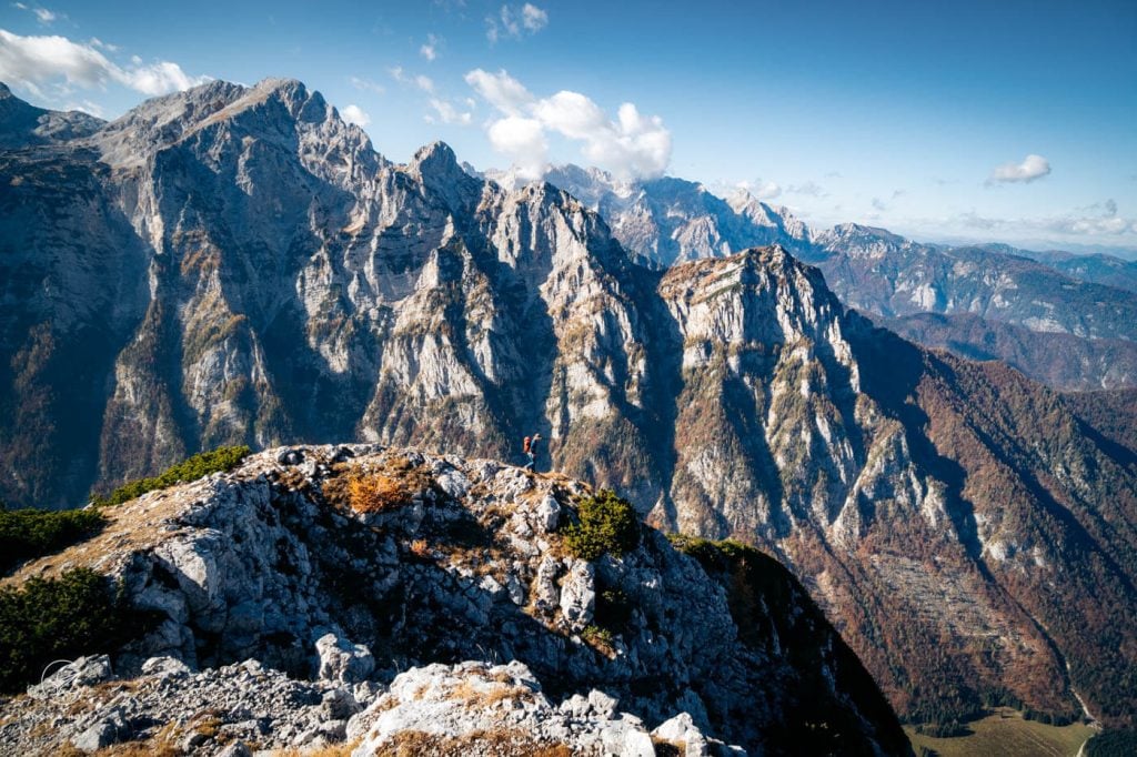
11. Seven Lakes Valley Hike, Julian Alps, Slovenia

Seven Lakes Valley is one of the most enchanting destinations in Triglav National Park in Slovenia and also one of our favorite day hikes in Europe.
Seven Lakes Valley, which is also called Triglav Lakes Valley, contains a string of seven lakes, each uniquely beautiful.
There are several different approaches to Triglav Lakes Valley, including the route starting at Koča pri Savici, accessible from Ukanc, and the one starting at Planina Blato, high above Stara Fužina.
Ukanc and Stara Fužina are two small settlements around Lake Bohinj.
We recommend hiking to Triglav Lakes Valley from Planina Blato, which is the easier approach. On the way to Seven Lakes Valley, you’ll hike across some of the loveliest alpine pastures in the Julian Alps, including Planina pri Jezeru, Planina Viševnik, and Planina Ovčarija.
From the Štapce saddle (1851 m), the trail descends to Dvojno Jezero (Double Lake), where the Koča pri Triglavskih jezerih (Triglav Lakes Hut) is happily situated. Eat lunch here, before starting the return journey.
If you thirst for adventure, consider hiking this challenging two-day Seven Lakes Valley hike, which follows the thrilling Špičje ridge.
Read Best Hikes in Slovenia for an overview of the best trails in Slovenia, including Viševnik Day Hike, Kamnik Saddle and Planjava, and Mala Osojnica: Lake Bled Viewpoint.
Trail Stats
Trailhead | Planina Blato
Distance | 14.2 km out-and-back
Difficulty | Easy-Moderate
Time Needed | 7 hours out-and-back
When to Hike | June – October
Recommended Itinerary | 2 Week Slovenia Road Trip
Where to Stay in Ribčev Laz | Hostel pod Voglom (budget), Apartments and rooms Cerkovnik (midrange), or Hotel Bohinj (luxury)
Where to Stay in Stara Fužina | Pr `Agotnik apartmaji sobe Bohinj (midrange), Hotel Majerca (midrange-luxury), or Apartmaji Triglav (midrange-luxury)
Learn more: Triglav Lakes Valley Day Hike
12. Tossals Verds Circuit Trail, Mallorca, Spain

Puig des Tossals Verds (1118 m) is a mountain in the Serra de Tramuntana range on the island of Mallorca.
A very satisfying circuit trail loops around Puig des Tossals Verds, following the GR 221 almost the whole way.
We loved this trail because it’s scenically varied. The trail meanders between beautiful limestone mountains, above narrow gorges, through olive groves and oak forests, and along a long water canal.
Starting near the Cúber Reservoir, the trail first ascends to Coll de sa Coma des Ases. From the saddle, the trail descends across a stunning high valley towards the Torrent d’Almedra stream/gorge.
It continues to the managed Refugio Tossal Verds and up through an olive grove and oak forest to Coll des Coloms. The final leg follows the Canal des Embassaments water canal all the way back to the Cúber bus stop/car park.
Read Best Hikes In Mallorca for a summary of the best trails in Mallorca, including: Cornador Gran Day Hike, Puig de l’Ofre Peak Hike, Talaia d’Alcúdia and Platja des Coll Baix Circuit Trail, La Trapa Viewpoint Hike, Castell d’Alaró Rock Castle Hike, and Path of the Archduke.
Trail Stats
Trailhead | Cúber Reservoir Car Park
Distance | 11.4 km circuit
Time Needed | 4:30 hours
Difficulty | Moderate
When to Hike | Fall (September – October), or Spring (April – May)
Recommended Itinerary | 7 Day Mallorca Road Trip
Where to Stay in Sóller | Hostel Sóller – Albergue Juvenil (budget), Hotel El Guía (midrange), Ecocirer Healthy Stay (vegan boutique B&B), and Finca Ca’s Curial – Agroturismo – Adults Only (luxury)
Learn More: Tossals Verds Circuit Trail
13. San Pedro to Agaete Hike, Gran Canaria, Spain

San Pedro is a hamlet in Agaete Valley (Valle de Agaete in Spanish) in northwest Gran Canaria.
A short, but stellar point-to-point hike leads from San Pedro up to Era de Berbique, an old threshing floor, and then down to Agaete and/or Puerto de las Nieves, the port of Agaete.
This trail is signed and in excellent condition. Overall, it’s a moderate hike with excellent views of Agaete Valley, the Riscos de Tamadaba, Roque Faneque cliffs, and the northwest coast of Gran Canaria. There’s no technical difficulty.
The path initially follows the pilgrim route Camino de los Romeros, passing the Cuevas de Berbique caves along the way.
Check out Best Hikes in Gran Canaria to learn more about the best trails in Gran Canaria, including: Agaete Valley to Tabadaba Circuit Hike, Playa de Guayedra, Tasartico to Güi Güi Beach, Roque Faneque, Roque Nublo, Cruz Grande to Pico de las Nieves, Cruz de Tejeda – La Culata Circuit, Cruz de Tejeda to Cuevas del Caballero, and Ventana del Nublo Viewpoint Hike.
Trail Stats
Starting Point | San Pedro, Valle de Agaete.
Ending Point | Puerto de las Nieves or Agaete
Distance | 8.3 km point-to-point
Time Needed | 3:45 – 4 hours
Difficulty | Moderate
When to Hike | November – March
Recommended Itinerary | 7 Day Gran Canaria Road Trip
Where to Stay in Agaete | Casa Calma Yoga Guesthouse (budget), Hotel Puerto de Las Nieves (midrange), or Hotel & Spa Cordial Roca Negra (luxury)
Learn More: San Pedro to Agaete
14. Kreuzeck to Höllentalklamm Gorge Hike, Bavarian Alps, Germany

Höllentalklamm (Valley of Hell Gorge) is a wild, narrow gorge located near Garmisch-Partenkirchen at the foot of Zugspitze in Upper Bavaria, Germany.
A thrilling, well-secured path leads through the gorge, rewarding hikers with a full-sensory experience of one of Bavaria’s greatest natural wonders.
This Kreuzeck to Höllental valley hike strings together a panoramic peak, an incredible ledge trail, the Höllentalangerhütte mountain hut, and of course the Höllentalklamm gorge. It’s a short day hike which keeps on giving.
Learn about the best hikes around Garmisch-Partenkirchen, including Lake Eibsee Circuit Trail, Partnach Gorge Hike, Alpspitze Via Ferrata (Grade A/B), and Hochplatte Peak.
Trail Stats
Trailhead | Kreuzeck Cable Car mountain station
Distance | 13 km circuit
Time Needed | 4:30 hours
Difficulty | Moderate in dry conditions
When to Hike | June – October, when the gorge is snow-free
Recommended Itinerary | 10 Day Bavarian & Tyrol Road Trip
Where to Stay in Garmisch-Partenkirchen | Olympiahaus (budget), Quartier – Lodges Biohotel (midrange-luxury), or Werdenfelserei (luxury)
Learn More: Kreuzeck to Höllentalklamm Gorge Hike
15. Red Wine Trail, Ahr Valley, Germany

The Red Wine Trail is a 35 km hiking trail from Altenahr to Bad Bodendorf in the Ahr Valley, Germany. Though the trail can be hiked from start to finish in two days, most hikers will walk a segment of the trail as a day hike.
Winding through steeply terraced vineyards, this romantic walking trail connects wine-making villages in Germany’s largest red-wine-growing region. The whole point of this hike is to savor the beauty of the sloping vineyards whilst tasting the region’s celebrated pinot noir wines. So, it’s basically a winery crawl.
Don’t miss the wines in Weingut O. Schell in Rech and the Flammkuchen in Weingut Kloster Marienthal.
Trail Stats
Trailhead | We recommend starting your hike in either Altenahr or Mayschoß.
Distance | Various (up to 35 km)
Time Needed | Depends on how much wine you drink
Difficulty | Easy
When to Hike | April – October
Where to Stay in Bad Neuenahr-Ahrweiler | Villa Aurora Bad Neuenahr (midrange), or Hotel Ahrbella (midrange)
Learn More: Ahr Valley Travel Guide
16. Grand Balcon Nord Hiking Trail, Chamonix, France

The highest mountain in Europe, west of the Caucasus, is Mont Blanc (4,809 meters / 15,777 feet). Straddling the French-Italian border, the Mont Blanc mountain range is famous for its cascading glaciers, ice-crusted domes, and sharp needle-like peaks.
People from all over the world flock to Chamonix, France. to see Mont Blanc. One of the most popular hiking trails in Europe circumnavigates the Mont Blanc Range. You’ve probably heard of it: the famous Tour du Mont Blanc.
You don’t have to be a mountaineer or a long distance hiker to take in the beauty of these magnificent mountains. There are some spellbinding balcony trails above Chamonix Valley, suitable for everyone.
The Grand Balcon Nord trail connects Montenvers with Plan de l’Aiguille. It’s an easy panoramic trail with wondrous views of Mer de Glace (Sea of Ice) glacier, the Aiguilles de Chamonix (Chamonix Needles) group of the Mont Blanc massif, and the Aiguilles Rouges massif.
Trail Stats
Trailhead | Montenvers-Mer de Glace train station in Chamonix
Distance | 12.6 km out-and-back
Time Needed | 4:40 hours
Difficulty | Easy
When to Hike | June – mid-September
Where to Stay in Chamonix | Heliopic Hotel & Spa (midrange – top choice), Chalet Hôtel Le Prieuré (midrange), or Alpina Eclectic Hotel & Spa Chamonix (luxury)
Learn More: Grand Balcon Nord Hike
17. Wachau World Heritage Trail, Austria

The Wachau World Heritage Trail (Welterbesteig in German) is a 180 km long hiking trail along the Danube River Valley in Austria. This trail is divided into 14 stages, each of which can be hiked as day hikes. From the trail, hikers enjoy sweeping views of the Danube river, steep terraced vineyards, and hilltop castles.
The Wachau Valley is one of Austria’s most romantic regions and it’s only a 1 hour drive, or train ride, from Vienna.
One of our favorite stages is from Dürnstein to Krems.
Though it’s possible to hike the Wachau World Heritage Trail all-year-round, Autumn is the most spectacular time of year.
If you extend your trip in the Wachau, also check out the Seekopf and Hirschwand Circuit Hike and the Vogelbergsteig Hike.
Trail Stats
Difficulty | Easy – Moderate
When to Hike | All year round
Where to Stay in Weissenkirchen | Hotel Garni Weinquadrat (midrange) or Hotel-Restaurant Kirchenwirt (midrange-luxury)
Where to Stay in Dürnstein | Bioweingut Schmidl (midrange), Hotel Schloss Dürnstein (luxury), or Hotel Richard Löwenherz (luxury)
18. Kallur Lighthouse Hike, Faroe Islands

The Faroe Islands are a group of 18 islands forged by volcanic activity and the glaciers of the ice age. This puzzle-shaped archipelago is located in the North Atlantic between Norway and Iceland.
The iconic Kallur Lighthouse is located in the very north of Kalsoy Island in the Northern Isles. It’s a small white-and-red structure set amid untamed landscapes, both majestic and harsh.
Backed by the fin-shaped Mount Borgarin, Kallur Lighthouse stands proudly on a confluence of falling ridgelines, high above the churning ocean. Undeniably, it’s one of the most captivating scenes in the Faroes.
The hike to Kallur Lighthouse starts in the village of Trøllanes. After entering the outfield, the trail climbs up the hillside and then crosses the eastern flank of Mount Borgarin (537 meters).
When you reach the lighthouse (35-45 minutes), you can continue north along a narrow strip of land to the iconic viewpoint of the lighthouse and Borgarin. Return to the lighthouse and follow the cliffs to the James Bond tombstone. In No Time to Die, James Bond meets his end on Kalsoy Island.
Read about the Best Hikes in the Faroe Islands, including Saksun to Tjørnuvík Hike on Streymoy Island, Múlafossur Waterfall and Gásadalur Hike on Vágar Island, Árnafjørður – Toftaskarð – Katlarnir Circuit Trail on Borðoy Island, and Klakkur Hike on Borðoy Island.
Trail Stats
Trailhead | Trøllanes
Distance | 4.8 km out-and-back
Time Needed | 1:30 hours
Difficulty | Easy-Moderate
When to Hike | June, July, or August
Recommended Itinerary | Faroe Islands Road Trip
Learn More: Kallur Lighthouse Hike
19. Debela Peč Peak Hike, Slovenia
Debela peč (2014 m) is a panoramic peak along the Lipanca Ridge, between Krma Valley and Pokljuka plateau in the Julian Alps of Slovenia.
The Debela peč hike begins at the Medvedova konta car park on Pokljuka, which is a 40-minute drive from Lake Bled.
Initially, you will follow a forest road to the managed Bled Hut (Blejska koča na Lipanci), which stands on the Planina Lipanca mountain pasture, ringed by larches.
The trail continues up to the summit of Brda (2009) and then along the Lipanca ridge to the summit of Debela peč (2014 m).
The views are extraordinary along the ridge, because you’ll see the long Karawanks chain, the high peaks of the Julian Alps, and Krma Valley below.
Trail Stats
Trailhead | Medvedova konta car park
Distance | 8.7 km out-and-back
Time Needed | 3:45 hours
Difficulty | Moderate
When to Hike | June – October, depending on weather conditions
Recommended Itinerary | Slovenia 2 Week Road Trip
Learn More: How to Hike to Debela peč
20. Ladder of Kotor Hike, Montenegro

The Ladder of Kotor (aka the Ladder of Cattaro) is a historic mule track, which was built in the 19th century by the Austrians, in order to connect Kotor with Njeguši and Cetinje, Montenegro’s former royal capital.
Starting just outside of the UNESCO-listed Old Town of Kotor, the rocky path climbs up the mountainside in a series of switchbacks between the Scurda Canyon and Kotor’s medieval fortifications.
Though the elevation gain is significant, the path is extremely well-graded. As you ascend, you’ll see the long Vrmac ridge , flanking the Bay of Kotor (aka Boka Bay). You’ll also see the San Giovanni Fortress (aka Kotor Fortress) and Pestingrad Peak.
Hike this trail in the morning to avoid the hot midday sun.
Find out where to hike around Kotor in our Kotor Hiking Guide.
Trail Stats
Trailhead | Tabačina Road, near the River Gate of the Old Town of Kotor
Distance | 14.1 km lollipop-circuit
Time Needed | 6 hours (4 hour variation possible)
Difficulty | Moderate
When to Hike | all-year-long
Recommended Itinerary | Montenegro 2 Week Road Trip
Learn More: Ladder of Kotor Trail Guide
21. Rötelstein Peak Hike, Salzburg, Austria

Rötelstein (2247 m), also called Rettenstein, is a mountain northeast of Filzmoos in Salzburg, Austria. It stands south of the awe-inspiring Dachstein massif.
The Rötelstein summit hike is thrilling as well as demanding. Hikers must be comfortable scrambling and tackling broken rock and scree terrain. This is a challenging day hike for experienced alpine hikers.
We love this hike, because it involves a lengthy technical ascent along the main crest of Rötelstein. The summit affords sweeping views of the Gosaustein and Dachsteinsüdwand (Dachstein South Wall), which is one of the most beautiful mountain ranges in Austria.
After a grueling descent to the Sulzenhals saddle, the hardest part of the hike is over. Eat a wonderful lunch on Sulzenalm mountain pasture at Wallehenal, or Krahlehenhütte, before completing the circuit.
Trail Stats
Trailhead | Rettensteinhütte Car Park, Filzmoos
Distance | 9.8 km circuit
Time Needed | 5 hours
Difficulty | Challenging
When to Hike | June – October, depending on conditions
Recommended Itinerary | Austria 2 Week Itinerary
Learn More: Rötelstein Peak Hike
22. Ruta del Cares Gorge Hike, Spain

Ruta del Cares is a spectacular hiking trail in Picos de Europa National Park in Northern Spain.
Picos de Europa National Park stretches across the Spanish regions of Asturias, Cantabria, and León (Castile and León). It encompasses the majestic Picos de Europa Mountains, a limestone mountain range composed of three massifs.
The Ruta del Cares path runs through the impressively deep Cares River Gorge, which divides the Western Massif (Cornión) from the Central Massif (Urrieles).
High above the river bed, the trail clings to the chiseled gorge wall, following a wide ledge with a sheer drop on one side. It’s a dramatic and spellbinding route.
You can start the Ruta del Cares trail in either the hamlet of Poncebos in Asturias, or in the village of Caín in León (Castilla y León).
Hailed as the most beautiful hike in Spain, the Ruta del Cares hike is not a secret. We recommend visiting Picos de Europa in late May, early June, or September to avoid the crowds.
Trail Stats
Trailhead | Poncebos (or Caín)
Distance | 23.6 km out-and-back
Time Needed | 6:45 hours (8 hours with breaks)
Difficulty | Moderate
When to Hike | mid/late May – mid/late October, depending on weather conditions
Recommended Itinerary | Picos de Europa Road Trip
Learn More: Ruta de Cares Hiking Trail
23. Piz Duleda Peak Hike, South Tyrol, Italy

Piz Duleda (2909 m) is a peak in Puez-Odle Nature Park in the Italian Dolomites.
This challenging day hike starts at the Col Raiser gondola mountain station, accessible from Selva di Val Gardena, in South Tyrol.
This excellent hike in Val Gardena involves a secured scramble with fixed cables and ladders.
The trail leads up the lonesome Val dla Roa valley to Furcela Dla Roa/Roa Scharte saddle and climbs up the Sentiero Attrezzato Piz Duledes (protected trail / Grade A) to Furcela Nives saddle. From Furcela Nives, it’s a straightforward ascent to the Piz Duleda summit.
The descent returns to Furcela Nives and then continues to Furcela Forces de Sieles, where it drops down the Forces de Sieles gully merging with the Col dala Pieres descending route.
We loved hiking to Piz Duleda, because it’s a quiet trail in one of the busiest places in the Dolomites.
If time allows, eat lunch at Rifugio Firenze (aka Regensburger Hütte), just 20-minutes from Col Raiser.
Trail Stats
Trailhead | Col Raiser Gondola mountain station, Val Gardena
Distance | 12.4 km lollipop-circuit
Time Needed | 5 hours
Difficulty | Challenging
When to Hike | late June – October, depending on conditions
Recommended Itinerary | 10-14 Day Dolomites Itinerary
Learn More: Piz Duleda Hiking Guide
24. Sentiero Bonacossa Secured Trail, Italy

Sentiero Alberto Bonacossa is a thrilling, semi-secured hiking trail that runs through the dramatic Cadini di Misurina mountain group in the Sexten Dolomites, in Northeastern Italy.
The Cadini di Misurina mountains are defined by sharp, slender spires and sloping cirques that dissect the massive towers.
This exciting trail guides hikers through the Cadini di Misurina mountains along narrow, exposed ledges and steep rocky valleys.
Sentiero Bonacossa connects three mountain huts: Rifugio Col de Varda, Rifugio Fonda Savio, and Rifugio Auronzo. It links Lake Misurina with the south face of Tre Cime di Lavaredo.
It can be hiked in its entirety, or sectioned off in loops. We hiked the northern Rifugio Fonda Savio to Rifugio Auronzo route one year, and the southern Col de Varda to Rifugio Fonda Savio route another year.
One of the most popular destinations along the Sentiero Bonacossa trail is the famous Cadini di Misurina viewpoint.
This trail is a sentiero attrezzato, which is something between a standard hiking trail and a via ferrata (klettersteig / protected climbing route). We recommend wearing climbing helmets and climbing gloves for this route. Some people may want to bring a via ferrata kit.
- Climbing Gloves: Black Diamond half finger gloves
- Women’s Climbing Helmet: Black Diamond women’s climbing helmet
- Men’s Climbing Helmet: Black Diamond men’s climbing helmet
North Trail Stats
Trailhead | Lake Antorno, or Rifugio Auronzo
Distance | 12.5 km circuit
Time Needed | 6 hours
Elevation Gain/Loss | 869 meters
Difficulty | Challenging
Learn More: Sentiero Bonacossa North Trail
25. Wolfsklamm Gorge Hike, Austria

Wolfsklamm (Wolf’s Gorge) is a river gorge in Karwendel Mountains near Innsbruck in Austria.
A safe and secure trail ushers hikers through a magical limestone corridor, where rock, water, and greenery harmoniously collide.
This short hike is suitable for families with children. It’s a great way to spend a few hours in nature, when you’re visiting Innsbruck. Read our Innsbruck hiking guide to learn more about where to hike around Tyrol’s capital city.
This gorge trail is only open between May and October, when the gorge is snow-free. For safety reasons, it’s only possible to ascend the gorge. At the end of the trail, hikers can extend their trip to Benedictine monastery of St. Georgenberg, or descend via the Way of the Cross over Weng path.
Trail Stats
Trailhead | Stans Wolfsklamm Parking
Distance | 5.4 km circuit
Time Needed | 2:15 hours
Elevation Gain/Loss | 410 meters
Difficulty | Moderate
Learn More: Wolfsklamm Gorge
More Europe Hiking and Travel Guides
Seasonal:
- Europe Spring Destinations
- Europe Summer Destinations
- Europe Winter Destinations
- Europe Autumn Destinations
Hiking:
Hiking-Themed Travel Inspiration:

Europe Hiking Packing List
Hiking Gear
- Day Hiking Backpack: Osprey Tempest 30 Women’s Backpack / Osprey Talon 33 Men’s Backpack
- Wool Hiking Socks: Smartwool womens Performance Hike Full Cushion Crew / Smartwool Men Performance Hike Full Cushion Crew
- Grade B or B/C Hiking Boots: Meindl Schuhe Island Lady (Kati’s Boots), Women’s Hanwag Tatra II GTX (Sabrina’s Boots), Men’s Hanwag Tatra II GTX (men’s equivalent)
- Hiking Poles: Black Diamond Trail Trekking Poles
- CAT 4 Sunglasses: Julbo Shield Mountain Sunglasses
Hiking Accessories
- Climbing Gloves: Black Diamond Half Finger Gloves. Climbing Gloves are invaluable for European hikes with secured passages like Sentiero Bonacossa (Italy) and Piz Duleda (Italy).
- Headlamp: Black Diamond Equipment Spot 350 Headlamp. Headlamps are essential for sunrise/sunset hikes like Gran Cir and Lake Federa (Dolomites).
- Microspikes: CAMP Snowline Chainsen Lightweight Microspikes. We pack microspikes whenever we’re hiking in the mountains early, or late in the European hiking season (e.g. May, June, October).
Outdoor Photography Gear
- Camera Body: Sony Alpha a6400
- Mid-range Zoom Lens: Tamron 17-70mm 2.8 Di III-A VC RXD
- Wide angle Zoom Lens: Sony – E 10-18mm F4 OSS Wide-angle Zoom Lens
- Backpack Camera Clip: Peak Design Camera Clip

Pin this Image for Future Trip Planning!
Stay Connected:
Connect with us on Pinterest.
Follow us on Instagram.
Like us on Facebook.
Support Us:
If you love reading our content, you can buy us a coffee via Ko-Fi.


Such an interesting list of day hikes in Europe is only possible for someone who is obsessed with hiking like you. I have read about Seven Sister Cliff before and it’s my dream to explore it one day.