Klakkur (413 meters) is a panoramic mountain which rises to the northwest of Klaksvík on Borðoy Island in the Faroe Islands.
The short, out-and-back hike to Klakkur ought to be a priority when visiting Klaksvík and the Northern Isles. With careful planning, it’s possible to combine the Kallur Lighthouse excursion with Klakkur in a single day.
The Klakkur hike starts directly in Klaksvík. But, if you’re driving, you can shorten the ascent by parking at the water tanks car park, just off Niðan Horn road. From this parking area, follow the gravel road, nicknamed Ástarbreytin (“Love Path”), to the Hálsur saddle. Along this track, there are lovely views of Klaksvík, wedged between two U-shaped inlets.
From Hálsur, continue north across boggy fields to the top of the mountain. Klakkur’s broad ridge treats hikers to far-reaching views of neighboring islands, including Kunoy and Kalsoy.

- Where: Borðoy Island
- Trailhead: Water tanks car park, Niðan Horn road, Klaksvík | Google Maps
- Distance: 6.2 km out-and-back
- Elevation Gain/Loss: 277 meters
- Time Needed: 2 Hours
- Difficulty: Easy-Moderate
- Minimum Elevation: 136 meters
- Maximum Elevation: 413 meters
- Hiking Fee: None
- Recommended Itinerary: Faroe Island Road Trip
- Where to Stay in Klaksvík: Romantic Klaksvik apartment (midrange), Spacious City Center Home by the Sea (midrange), or Panorama boathouse (luxury)
- Where to Stay in Tórshavn: Hilton Garden Inn Faroe Islands (midrange-luxury), Hotel Brandan (luxury), Havgrím Seaside Hotel 1948 (luxury)
Klakkur Hiking Map
Where to Start the Klakkur Hike
Water Tanks Car Park, Klaksvík
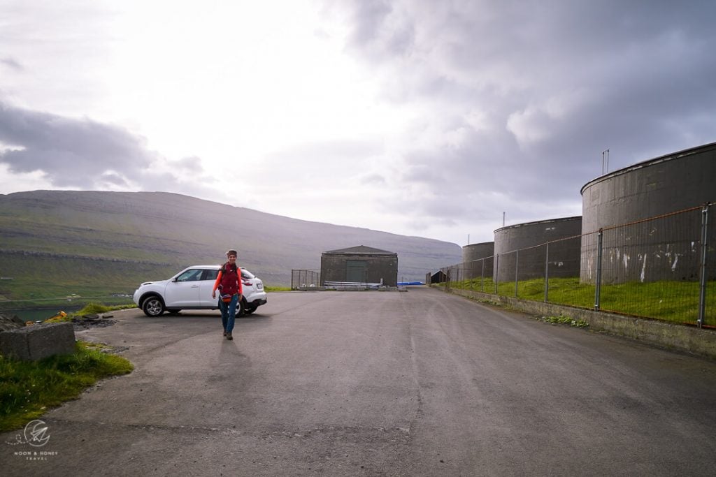
Though it’s possible to start the Klakkur hike from anywhere in Klaksvík, you can save some time by driving up Niðan Horn road to the water tanks. There’s a parking area directly in front of the tanks.
Exact Location: Google Maps
Hálsur Car Park, Klaksvík
It’s also possible to continue driving all the way to the car park at Hálsur, the mountain pass between Klakkur and Hálgafelli.
We’d discourage that because it’s far lovelier to walk to Hálsur.
Exact Location: Google Maps
Klakkur Hiking Trail Description
Klaksvík to Hálsur (30 minutes)

Starting at the water tanks car park, follow the gravel road northwest. This path is called Ástarbreytin, which means the “Love Path.” It’s a popular walking area among locals.
The road cuts across the eastern slopes of Hálgafelli and rises gently to the Hálsur saddle.
Along the way, the road passes farm buildings and roaming sheep.

Off to the right, you’ll see Klaksvík and its sheltered harbor.
The gravel road leads to Hálsur saddle, marked with a small car park and a hiking route info board.
Hálsur to Klakkur (30 minutes)
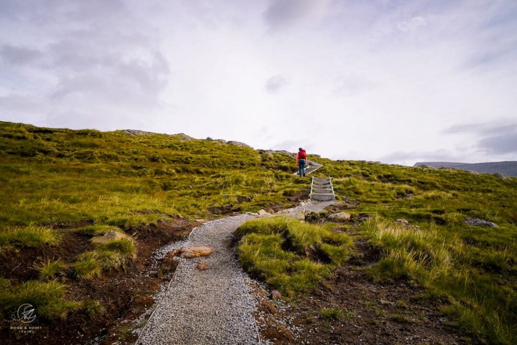
Pass through the gate and walk along the small reservoir.
The footpath ahead is clear, as it’s initially strewn with gravel and bolstered with a few timber stairs.
From the onset, you’ll see the transmitter mast atop Klakkur, which is your “North Star.”
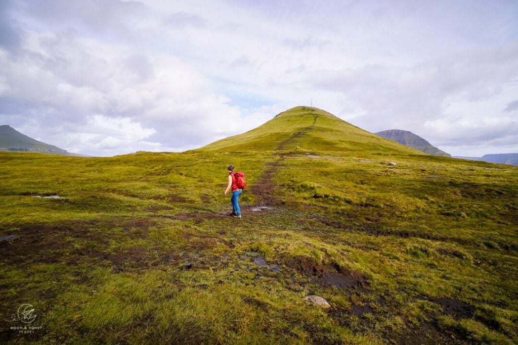
The way rises to a large cairn at the base of the Klakkur hill. This area is extremely muddy after rain, so the trail braids into different paths to avoid boggy areas and ponds.
Continue straight, picking your way carefully across the peat field. The path steepens significantly and climbs straight up to Klakkur.
When you crest, continue north along the broad, panoramic ridge. Walk by the transmitter mast and red cottage.
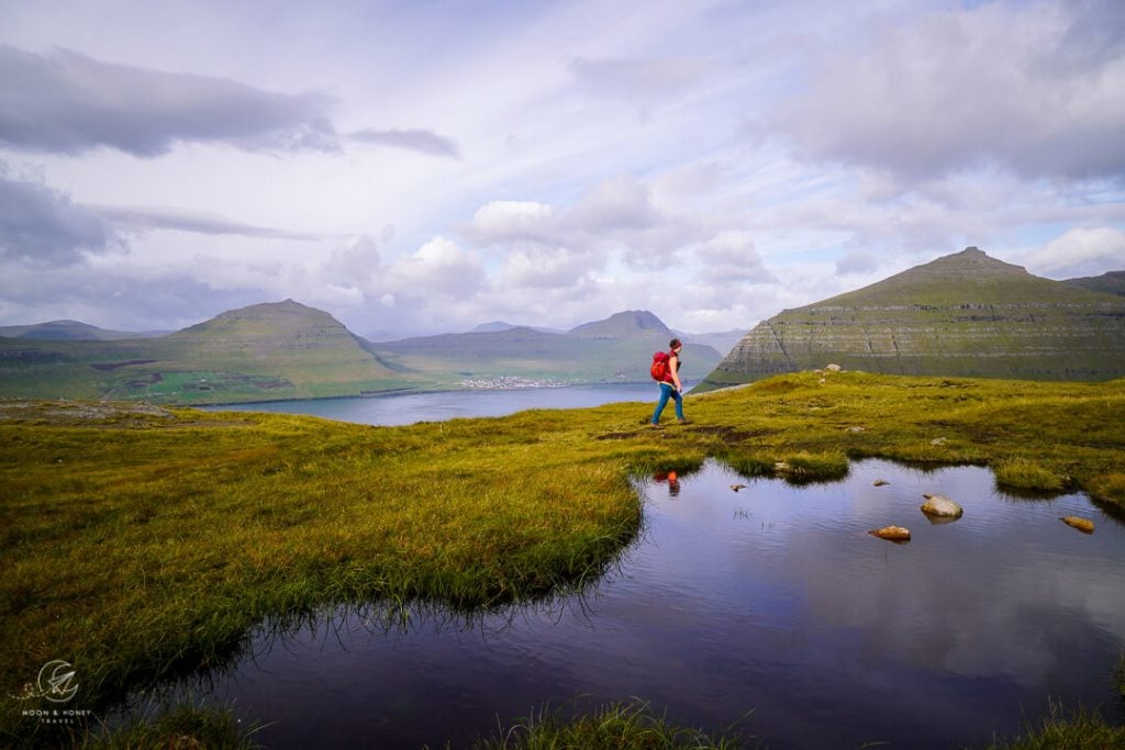
The slender and mountainous Kalsoy Island lies to the northwest in the shape of a sea serpent. Kalsoy’s eastern coast is punctuated with the tiny settlements of Syðradalur and Húsar.

Keep walking along the ridge until you reach a natural viewpoint facing Suður á Nakki (703 m), the southernmost mountain of Kunoy Island. From this unique vantage point, Suður á Nakki looks like a giant sunray venus seashell.

To the southwest, you can see an arm of Eysturoy Island, home to Leirvík village.
And to the northeast, you can see Bordoy Island curling around Kunoy.
Like so many places in the Faroe Islands, the scenery looks mythical.
Klakkur is a flat-topped mountain defined by its long horizontal ridge. So, the actual Klakkur mountain summit isn’t terribly significant, because it’s not a visibly pronounced, or elevated point. The whole ridge is essentially the top of Klakkur, but the best views are at the northern point.
Klakkur Photo Spot

From the ridge, it’s possible to descend further north, following a footpath. However, this trail is narrow, semi-exposed, and potentially dangerous.
Klakkur to Klaksvík (1 hour)

Return along the same route, enjoying the views of pyramid-shaped Hálgafelli and Háfjall directly ahead.
Where to Stay near Klakkur
Klaksvík, Borðoy Island

Klaksvík, located on Borðoy island, is the second largest town in the Faroe Islands. Klaksvík is the best base for exploring the Northern Isles. We recommend staying here for 2 nights, so that you can visit Kallur Lighthouse on Kalsoy Island and hike to Villingardalsfjall on Vidoy Island. Experienced hikers with excellent trail intuition ought to tackle the Árnafjørður – Toftaskarð – Katlarnir circuit trail.
Midrange | The welcoming and cozy Romantic Klaksvik apartment is a one-bedroom apartment with a fully-equipped kitchen, living room, garden, and private parking. The apartment is walking distance to the Kalsoy ferry.
Midrange | Spacious City Center Home by the Sea is located in the heart of Klaksvík, close to Fríða Kaffihús, tourist office, Kalsoy ferry terminal, and grocery store. This roomy and bright 3-bedroom apartment has a fully-equipped kitchen (with dishwasher and microwave), a washing machine, balcony, and free parking.
Top Choice – Luxury | Set along Klaksvík bay, Panorama boathouse stands out with its crisp, modern aesthetic, new furnishings, and idyllic setting. This beautifully converted boathouse has 3 bedrooms, a well-equipped kitchen, a washing machine, a spacious dining area, and a living room.
Look for accommodation in Klaksvík.
Tórshavn, Streymoy Island
Tórshavn, the capital of the Faroe Islands, is located on Streymoy Island. Not surprisingly, it’s also the largest and liveliest city in the Faroes, with the highest concentration of accommodations, restaurants, and bars.
Many travelers decide to base themselves in Tórshavn for the full duration of their trip and take day trips to Saksun and Tjørnuvík, Vágar Island (Múlafossur Waterfall and Trælanípa Cliff Trail to the Floating Lake), Eysturoy Island (Gjogv Village and Hvíthamar Viewpoint), and the Northern Isles.
From Tórshavn, you can also take ferries to Nólsoy Island, Sandoy Island, and Suðuroy Island.
TOP CHOICE – Midrange-Luxury | Hilton Garden Inn Faroe Islands is a fresh-faced hotel set in a quiet location, 1.6 km from the city center (20 minute walk, or 4 minutes drive). Stay here for the impeccably-designed rooms with comfortable beds, the on-site restaurant and bar, great breakfast buffet, and fitness center. Free on-site parking.
Luxury | Hotel Brandan is a 4-star hotel with quiet rooms, an on-site restaurant, a fitness center, a sauna, and on-site parking. Guests love the breakfast and the hotel bar, which serves local craft beers. The hotel is located 1.4 km from the city center (15 minute walk, or 3 minute drive).
Luxury | Havgrím Seaside Hotel 1948 is a boutique hotel set on the seashore, walking distance to the city center (10 minutes). A fantastic breakfast is included. Free parking is available on-site. Guests can also enjoy the garden hot tub facing the sea.
Luxury | Traditional Faroese house in Tórshavns city center is a 4-bedroom turf-roofed house with stylish, renovated interiors, two bathrooms, and a well-equipped kitchen. Free on-site parking. 3 nights minimum stay.
More Charming Holiday Homes: Cosy house in the heart of Tórshavn (Á Reyni) and Luxurious House in Downtown Tórshavn
City Center Apartments: City center, Tórshavn (2-bedroom apartment), Central apartment in Tórshavn (1-bedroom apartment), Penthouse Apartment in Downtown Tórshavn (3-bedroom/5 people apartment)
Look for accommodation in Tórshavn.

More Faroe Islands Travel Guides
Hiking:
Read Best Hikes in the Faroe Islands for a summary of the top hiking trails across the archipelago. Our favorite Faroe Islands hiking trails (north to south):
- Villingardalsfjall Hike, Viðoy Island
- Árnafjørður – Toftaskarð – Katlarnir Circuit Trail, Borðoy Island
- Klakkur Hike, Borðoy Island
- Kallur Lighthouse Hike, Kalsoy Island
- Hvíthamar Viewpoint Hike, Eysturoy Island
- Saksun to Tjørnuvík Hike, Streymoy Island
- Múlafossur Waterfall and Gásadalur Hike, Vágar Island
- Lake Sørvágsvatn and Trælanípa Cliff Hike (Floating Lake Viewpoint), Vágar Island
- Ásmundarstakkur Hike, Suðuroy Island
- Hvannhagi and Lake Hvannavatn, Suðuroy Island
Travel:

Pin this Image for Future Trip Planning!
Stay Connected:
Connect with us on Pinterest.
Follow us on Instagram.
Like us on Facebook.
Support Us:
If you love reading our content, you can buy us a coffee via Ko-Fi.

