The Kallur Lighthouse (also called the Kalsoy Lighthouse) stands on Kallurin, the northernmost promontory of Kalsoy Island in the Faroe Islands. It’s a small structure set amid untamed landscapes, both majestic and austere.
Dwarfed by the sail-shaped Mount Borgarin (537 meters), the Kallur Lighthouse sits on the confluence of several ridges. Like so many places in the Faroe Islands, Kallurin’s allure lies in the dramatic contrasts between soft and harsh, light and dark, and smooth and rugged. Here, at what feels like the edge of the world, a small and fragile beacon of light defiantly offers guidance in a wild and perilous place. It’s visual poetry.
On a fair-weather day, the out-and-back hike from Trøllanes village to Kalsoy Lighthouse is short and straightforward. It only takes 35-45 minutes one-way.
However, getting to Kalsoy Island requires effort and careful planning. The only way to get to Kalsoy is by ferry from Klaksvík, Borðoy Island. Given infrequent ferry departures and limited capacity, it’s important to plan ahead and book the Sam ferry in advance.
If you don’t want to worry about logistics, you can also join one of these guided tours from Tórshavn: 10-hour Official James Bond Tombstone Tour in the Faroe Islands, 8-hourIncredible Guided Tour to Kalsoy & Kallur Lighthouse, or 7-hour Private Kallur Lighthouse Experience.

Kallur Lighthouse Trail Stats
- Ferry Route: 56 Klaksvík – Syðradalur
- Where: Kalsoy Island
- Trailhead: Trøllanes | Google Maps
- Distance: 4.8 km out-and-back
- Time Needed: 1:45 hours
- Elevation Gain/Loss: 327 meters
- Difficulty: Easy-Moderate
- Minimum Elevation: 0 meters
- Maximum Elevation: 197 meters
- Hiking Fee: 200 DKK for Adults and 100 DKK for Children
- Where to Stay in Klaksvík: Romantic Klaksvik apartment (midrange), Spacious City Center Home by the Sea (midrange), or Panorama boathouse (luxury)
- Where to Stay in Tórshavn: Hilton Garden Inn Faroe Islands (midrange-luxury), Hotel Brandan (luxury), Havgrím Seaside Hotel 1948 (luxury)
Kallur Lighthouse Hiking Map
How to Get to Kalsoy Island
Kalsoy Ferry: Route 56 from Klaksvík to Syðradalur

The only way to get to Kalsoy island is by ferry. The 20-minute route 56 Kalsoy ferry connects the town of Klaksvík on Borðoy Island with the village of Syðradalur on Kalsoy Island.
The small Kalsoy ferry accommodates pedestrian passengers and only 12 cars. If you intend to travel to Kalsoy with your car, book the ferry crossing in advance.
Alternatively, you can travel on board as a pedestrian and use transit to reach Trøllanes, the starting point of the Kallur Lighthouse hike. The buses on Kalsoy are synced with the ferry arrivals/departures.
All in all, I think it’s far more relaxing and time efficient to travel to Kalsoy as a pedestrian. Pedestrians can also book their passage on the Sam ferry in advance. Use the same booking portal and click “Book Only Passengers.”
Ferry Timetable | Depending on the day of the week, there are 5 or 6 daily ferry departures to Kalsoy Island. On the timetable, there’s an extra return ferry in the late evening (10:35 pm from Syðradalur back to Klaksvík). You can request this route latest by 7 pm by calling +298 293116 or +298 293106. We did and it worked out perfectly. See Route 56 timetable.
Kalsoy Ferry Price | See up-to-date ferry pricing under Route 56.
Ferry Reservations | You can book the M/F Sam Ferry in advance.
Klaksvík Ferry Terminal

“Ferry Terminal” is a bit of an overstatement. It’s more like a car park waiting area.
The waiting area for the ferry is located just off Stangavegur road, between Føroya Keypsamtøka grocery store and the Magn gas station. Exact Location: Google Maps.
There are three lines. Line 1 is for Kalsoy residents only. Lines 2 and 3 are for everyone else.
After parking your car, you’re free to leave and explore Klaksvík. Just return to your car 20-30 minutes in advance of the departure. While waiting, you can eat lunch at Fríða Kaffihús, grab a coffee from the Effo gas station, or check out the local handmade wool garments at Norðoya Heimavirki.
If you arrive at the Klaksvík ferry terminal and there are already 12 cars waiting in line, we recommend parking your car in the nearby parking lot and then hopping on as a pedestrian.
Boarding the Ferry | After all foot passengers have boarded the ferry, attendants guide drivers in line 1 (residents only), followed by cars in lines 2 and 3 onto the ferry. Cars are tightly packed onto the ferry. It’s a bit intimidating.
How to Get to Kallur Lighthouse

The Kallur Lighthouse hike starts in Trøllanes, the northernmost village on the island of Kalsoy.
If you’re traveling to Kalsoy Island on foot, you can take bus 506 from Syðradalur to Trøllanes. The bus schedule is coordinated with the ferry schedule.
Driving to Trøllanes
From the ferry terminal in Syðradalur, it’s a 20-25 minute drive (16.6 km) to Trøllanes. You will drive through 4 one-lane tunnels on your way to Trøllanes.
Upon exiting the ferry, turn right and drive north. The road hugs the coast, passing the village of Húsar.
Cautiously drive through a series of dark tunnels: (1) Villingardalstunnilin, (2) Ritudalstunnilin, and (3) Mikladalstunnilin. All of the tunnels are one-lane with periodic turn-outs, about every 100 meters.
After the third tunnel, you can detour to the village of Mikladalur, home to the famous Seal Women statue and Café Edge.
You’ll pass through one final tunnel, (4) Trøllanestunnilin, before reaching Trøllanes.
There are two small car parks in Trøllanes. There is no parking fee. The first parking area is located on the right side of the road, as you’re driving into the village: see Google Maps. The second car park is located in the village, next to the public toilets. This is the closest parking area to the trailhead: Google Maps
Kallur Lighthouse Hike Trail Description
The hike to Kallur Lighthouse traverses private land. There is a hiking fee to hike this trail. Please be respectful during your visit (do not disturb the sheep, no littering, no yelling, no playing music, etc…).
The hiking trail to Kallur Lighthouse is only open during certain times during the week.
Monday – Friday | 9 am – 6 pm
Saturday | 9 am – 5 pm
Sunday | 11 am – 5 pm
Trøllanes to Kallur Lighthouse (30 – 45 minutes)

Follow the road leading north, away from the village center. The sea is on your right. Walk over the cattle grid and follow the gravel track. Pass through the red gate.
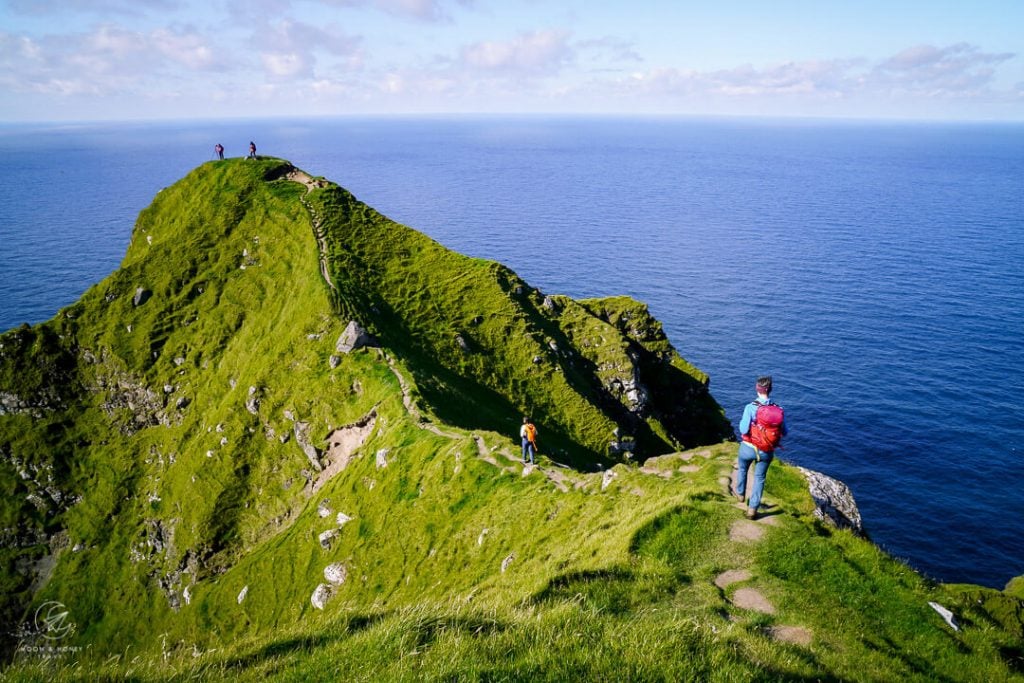
Now, you’re at the foot of a grassy hill. The path leads right. Aim for 2:00/2:30 and ascend the slope at a diagonal.
At the crest of the hill, there’s a stone shelter ruin. That’s your initial goal.

Note: there are various footpaths leading up the hill. We followed a lower path. When we reached the fence, the path sharply turned left and ascended to the stone shelter and boulder.
From the stone shelter, an obvious, wide path continues north.
There are no waymarks, or signs. Simply follow the existing trail around the eastern flank of Mount Borgarin (537 meters).
The grassy landscape is dotted with crumbling stone shelters, grazing sheep, and the occasional rivulet.
The Kallur lighthouse trail continues across Mount Borgarin’s eastern slopes, maintaining the same northwesterly direction.

To your right, you can see the finger-shaped islands of Kunoy and Viðoy.
Soon, the famous Kallur Lighthouse comes into view. It’s a rather small, red-and-white structure perched on a grassy hill. From this vantage point, there’s very little awe factor.

The meadows ahead are etched with various sheep paths and footpaths. Follow the best path (the least muddy) to the Kalsoy Lighthouse.
Several viewpoints fan out from the Kallur Lighthouse. Take your time to explore each one.
Kallur Lighthouse to Iconic Kallur Lighthouse Photo Spot (2 minutes)
Just beyond the lighthouse to the north, there is a narrow ridge path, which leads to the most iconic vantage point of the Kallur Lighthouse.
This narrow path dips down a few meters and then makes a counter-ascent to a small grassy plateau. Sheep also enjoy this trail.

This ridge path should only be attempted if conditions permit: no fog and no strong winds. Those who suffer vertigo and have a fear of heights may find this too hair-raising.
As you traverse this narrow spine of land, take a moment to look to your left. You can see the Risin og Kellingin sea stacks off in the distance. These are the same sea stacks that are visible from the Saksun to Tjørnuvík trail.
From this vantage point, the Kalsoy Lighthouse is dwarfed by the sheer rock face of Mount Borgarin.

After enjoying this much sought-after viewpoint, retrace your steps back to the lighthouse.
Kallur Lighthouse to James Bond Tombstone (3-4 minutes)
From the Kallur lighthouse, follow the path leading south along the cliffs. This trail ascends to the newly erected James Bond Tombstone.
In No Time to Die, James Bond meets his end on Kalsoy Island.
The James Bond gravestone reads “In memory of James Bond 1962 – 2021. The proper function of a man is to live, not to exist.”
Kallur Lighthouse to Eastern Ridge Viewpoint (5 minutes)
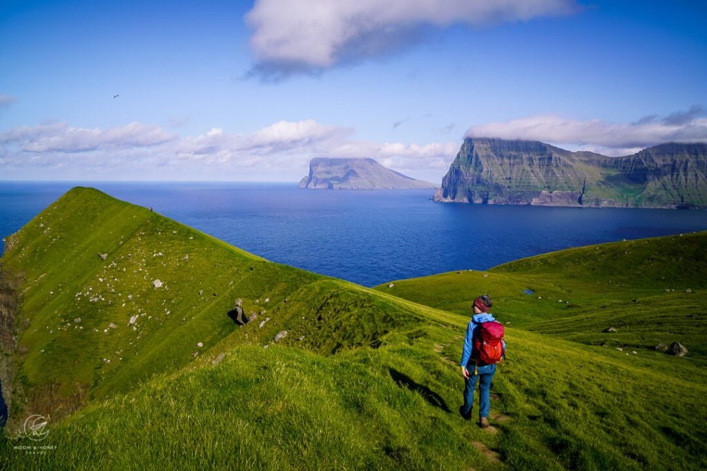
From the lighthouse, head east to this ridge viewpoint. This vantage point offers interesting views of the lighthouse, the Risin og Kellingin sea stacks, and the Northern Isles.

Kallur Lighthouse to Trøllanes (35-45 minutes)

Follow the same trail back to Trøllanes.
Returning to Klaksvík

Drive back to Syðradalur and line up for the ferry. It’s possible that you will have to wait 1-2 hours to get on a ferry back to Klaksvík.
Bring a book and snacks, so the wait is more tolerable.
We didn’t want to wait in line, so we took the extra departure (by request only) in the late evening. That only makes sense if you’re staying in Klaksvík.
Your ferry ticket covers the cost of the return journey to Klaksvík. So, you will not need to purchase any further tickets.
Visit Mikladalur
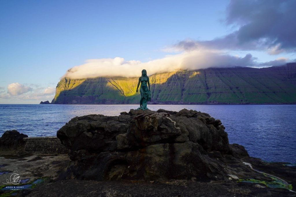
On your way back to the ferry, swing by Mikladalur. The village is located on Kalsoy’s eastern coast, south of Trøllanes.
Mikladalur’s main attraction is the 2.5-meter-tall statue of the Seal Woman by sculptor Hans Pauli Olsen.
The bronze and stainless steel sculpture depicts a naked woman shedding her seal skin. It’s an ode to the legendary Seal Woman (Kópakonan in Faroese), one of the most famous folktales in the Faroe Islands.
The unabridged tale is actually quite harrowing. It’s a story of abduction, greed, heartbreak, and revenge.
To see the statue, follow Bakkavegur road to the coast. Pass Café Eðge and walk down the steps to the shore, where the statue is bolted onto one of the rocks.
Where to Stay
Klaksvík, Borðoy Island
Klaksvík, located on Borðoy island, is the second largest town in the Faroe Islands. Klaksvík is the best base for exploring the Northern Isles. We recommend staying here for 2 nights, so that you can hike up to Klakkur, visit Kallur Lighthouse on Kalsoy Island, and hike to Villingardalsfjall on Viðoy Island. Experienced hikers looking for an adventure should check out the Árnafjørður – Toftaskarð – Katlarnir hike.
Midrange | The welcoming and cozy Romantic Klaksvik apartment is a one-bedroom apartment with a fully-equipped kitchen, living room, garden, and private parking. The apartment is walking distance to the Kalsoy ferry.
Midrange | Spacious City Center Home by the Sea is located in the heart of Klaksvík, close to Fríða Kaffihús, tourist office, Kalsoy ferry terminal, and grocery store. This roomy and bright 3-bedroom apartment has a fully-equipped kitchen (with dishwasher and microwave), a washing machine, balcony, and free parking.
Top Choice – Luxury | Set along Klaksvík bay, Panorama boathouse stands out with its crisp, modern aesthetic, new furnishings, and idyllic setting. This beautifully converted boathouse has 3 bedrooms, a well-equipped kitchen, a washing machine, a spacious dining area, and a living room.
Look for accommodation in Klaksvík.
More Faroe Islands Travel Guides
Hiking Guides:
Read Best Hikes in the Faroe Islands for a summary of the top hiking trails across the archipelago. Our favorite Faroe Islands hiking trails (north to south):
- Villingardalsfjall Hike, Viðoy Island
- Árnafjørður – Toftaskarð – Katlarnir Circuit Trail, Borðoy Island
- Klakkur Hike, Borðoy Island
- Kallur Lighthouse Hike, Kalsoy Island
- Hvíthamar Viewpoint Hike, Eysturoy Island
- Saksun to Tjørnuvík Hike, Streymoy Island
- Múlafossur Waterfall and Gásadalur Hike, Vágar Island
- Lake Sørvágsvatn and Trælanípa Cliff Hike (Floating Lake Viewpoint), Vágar Island
- Ásmundarstakkur Hike, Suðuroy Island
- Hvannhagi and Lake Hvannavatn, Suðuroy Island
Trip Planning:


Pin this Image for Future Trip Planning!
Stay Connected:
Connect with us on Pinterest.
Follow us on Instagram.
Like us on Facebook.
Support Us:
If you love reading our content, you can buy us a coffee via Ko-Fi.


Hello, I can see on the ferry page that I can book a ticket to get to – and back from – Kalsoy island. Can you confirm that thingd have changed since you wrote the article and that now the trip is “bookable” in advance ?
Thank you for your wonderful articles.
Regards,
P.
Hi Philippe,
You’re absolutely right. They changed that this year. Definitely book the ferry in advance.
Have a great trip to the Faroe Islands!
Sabrina
Hello!
Just came across your page and wanted to ask at what time you arrived on the island? The lighting on your pictures looks amazing and I was wondering if this is morning or late afternoon light? Going there in August!
Thank you,
Andreas
Hi Andreas,
These photos of Kalsoy Island were taken in the afternoon.
Have a great trip to the Faroe Islands,
Sabrina