Trekking Europe has become our favorite pastime. Each year, we’re on a mission to hike more and write about all our favorite trails.
In this guide, I’ve compiled all our favorite multi-day treks in Europe, ranging from 3 to 10 days, ordered by difficulty. The majority of these European hiking trails are hut-to-hut or village-to-village, which means you’ll overnight in mountain huts or guesthouses along the way.
In contrast to most round-ups of top treks in Europe, my collection ventures far off the beaten path, highlighting some of Europe’s most underrated and lesser-known hiking trails, reflecting my love for quieter, more adventurous routes.
We have integrated the popular Tour du Mont Blanc and Alta Via 1 treks into our guide as a technical difficulty reference.

- When to Trek in Europe: The best time to embark on multi-day treks in the Alps and Nordic Europe is between early July and mid September. The best time to hike around the Mediterranean and Southern Europe is in spring and fall
- When to Book Treks in Europe: This varies depending on the popularity of the trek. If you want to hike the world-famous Tour du Mont Blanc, or Alta Via 1, it’s best to book these routes 9-12 months in advance. If you want to book a lesser-known trail, it’s usually possible to book a few months in advance (or even a few weeks in advance).
- Packing List: hut-to-hut hiking packing list
1. South West Coast Path, England
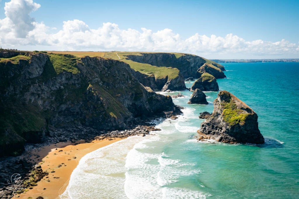
The South West Coast Path unfurls for 1,014 km (630 miles) along England’s south west peninsula, starting in Minehead in Somerset and ending in Poole Harbour in Dorset. Weaving past windswept cliffs, hidden coves, and postcard-perfect fishing villages, this breathtaking coastal path carries an irresistible magic.
While few tackle the entire path, hiking a section offers an unforgettable blend of seaside scenery, cozy inns, and dazzling beaches. With luggage transfers and private rooms available at the end of every stage, this is one of Europe’s most rewarding and surprisingly comfortable long-distance treks.
Over the years, Kati and I have explored the South West Coast Path as day hikers, petsitters in Newquay, and multi-day trekkers. After recently walking two weeks from Westward Ho! to St. Ives, I can confidently say the village-to-village trek was unbeatable.
Starting Point | Minehead, Somerset
Ending Point | Poole Harbour, Dorset
Duration | Up to 2 months
Distance | 1,014 km point-to-point
Difficulty | Easy – Moderate
When to Hike | May – September
Accommodation | B&Bs and Hotels. Camping is allowed in official campsites and caravan parks. According to the official SWCP website: “[wild] camping on the Coast Path without consent from the landowner is trespass.”
2. Rota Vicentina Fisherman’s Trail, Portugal

The original Rota Vicentina Fisherman’s Trail is a 4-day trek along Portugal’s wild and undeveloped Vicentina Coast. The trail starts in Porto Covo in Alentejo and ends in Odeceixe in the Algarve.
Clinging to the coast almost the whole time, this thrilling multi-day hike gives you access to some of Portugal’s most remote beaches and cliffside villages.
Though camping in designated camping areas is possible, it’s not recommended. Most hikers will overnight in guesthouses and hostels along the route in the towns of Vila Nova de Milfontes, Almograve, Zambujeira do Mar, and Odeceixe.
If you’re just getting into multi-day hiking (and you’re ambivalent about shared rooms and rustic facilities), this is a perfect place to start. You don’t have to sacrifice comfort in the name of adventure. You get both. And, you can even get your luggage transferred between destinations.
If you want to integrate this trek into a longer trip to Portugal, read our 2-week Portugal itinerary (no car needed).
Starting Point | Porto Covo
Ending Point | Odeceixe
Duration | 4 Days
Distance | 75 km point-to-point
Difficulty | Easy – Moderate
When to Hike | Spring (April, May), or Fall (October, November)
Accommodation | Guesthouses
Insider Tip | Make a reservation for dinner at Tasca do Celso before you arrive in Vila Nova de Milfontes.
3. High Tatras Hut-to-Hut Hike, Slovakia
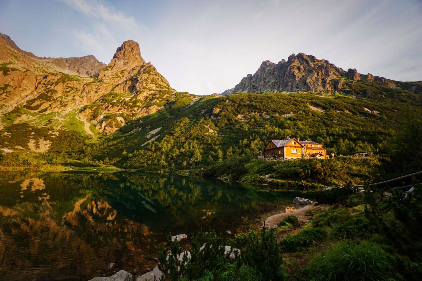
The High Tatras are the highest mountain range in the Carpathian Mountains, stretching from Northern Slovakia into Southern Poland.
We hiked 4-days on the Slovakian side, starting in Tatranská Kotlina village and ending in Strbske pleso. We loved the alpine lakes, the cozy mountain huts, and the collective spirit on the trail.
Hikers – mostly Slovaks and Czechs – greet with a genuine smile and a cheerful Ahoj or Dobrý deň. We felt comfortable, welcome, and at ease every day of our trek.
We especially relished the food, specifically the Halušky s bryndzou (potato dumplings with sheep cheese) and Buchty na pare (sweet steamed buns).
Starting Point | Tatranska Kotlina near Poprad
Ending Point | Štrbské Pleso
Duration | 4 Days
Distance | 55 km point-to-point
Difficulty | Easy – Moderate
When to Hike | Mid-June – End of October. We recommend late June, September, or early October.
Accommodation | Mountain Huts. Camping is forbidden.
Insider Tip | Eat Ovocné gule (fruit balls with berries) at the Zamkovského chata mountain hut.
4. Tre Cime di Lavaredo Hut to Hut Hike, Dolomites, Italy

This 3-day hut-to-hut hike in the Sexten Dolomites in Northern Italy expands on the popular Tre Cime di Lavaredo circuit trail.
Instead of driving directly to the famous three peaks, you’ll approach Tre Cime di Lavaredo from Val Fiscalina/Fischleintal valley, a picturesque side valley of Sexten in Hochpustertal (Alta Pusteria).
On day one, the trail leads through Fischleintal Valley and further up Val Sasso Vecchio (Altensteintal in German) to reach Dreizinnenhütte, the mountain hut facing the northern side of the Three Peaks. If Dreizinnenhütte is fully booked, you can also stay in the nearby Rifugio Lavaredo.
On the second day, the trail wraps around the Three Peaks, passing Rifugio Lavaredo and Rifugio Auronzo along the way. From Rifugio Auronzo, don’t miss the impressive detour to the famous Cadini di Misurina viewpoint. The trail returns to Dreizinnenhütte and then ascends to Büllelejochhütte, the highest refuge in the Sexten Dolomites. This charming hut is one of the most beloved in the Alps, frequently featured on the covers of hiking magazines.
The final day is a straightforward descent to Val Fiscalina via Zsigmondyhütte.
We hiked this route during our first trip to the Dolomites. Read our 1-week Dolomites itinerary to see how we integrated this 3-day trek into a 7-day road trip.
Starting Point/Ending Point | Val Fiscalina/Fischleintal, Sesto/Sexten
Duration | 3 Days
Distance | 27 km circuit
Difficulty | Easy – Moderate
When to Hike | Late June – Late September
Accommodation | Mountain Huts. Camping is forbidden.
5. Alta Via 1, Dolomites, Italy

The Alta Via 1 (aka Dolomiten Höhenweg 1) is an easy to moderate hut-to-hut hiking trail in the Italian Dolomites, starting at Lago di Braies (Pragser Wildsee) in South Tyrol and ending at the La Pissa bus stop near Belluno.
This 120-km-long Dolomites high route is hiked north to south and generally broken up into 10 or 11 stages. Many hikers will hike the north route (4 stages), or the south route (6 stages).
Given the popularity of this route, it’s critical to book mountain huts nine months in advance. See my guide to How to Book the Alta Via 1 Rifugios. I recommend saving yourself the headache of booking this trek independently and outsourcing the logistics to Alpenventures UNGUIDED. They have a relaxed-paced 13-Day Alta Via 1, moderately-paced 10-Day Alta Via 1, fast-paced 7-Day Alta Via 1 as well as other Dolomites routes.
Starting Point | Lago di Braies
Ending Point | Belluno (La Pissa bus stop)
Duration | 10 – 13 Days
Distance | 120 km point-to-point
Difficulty | Easy – Moderate
When to Hike | July, August, September
Accommodation | Mountain Huts. Camping is forbidden.
Related: Self-Guided Hiking Tours in the Dolomites
6. Tour du Mont Blanc, France, Italy and Switzerland

The Tour du Mont Blanc (TMB) is a spectacular multi-day hike that circuits the Mont Blanc massif in usually 10-11 days covering a total distance of 170 km (105 miles).
Traditionally, the Tour du Mont Blanc hike starts in Chamonix, France (Haute-Savoie).The trail circuits the Mont Blanc range counterclockwise, passing through Italy (Aosta Valley) and Switzerland (Valais) as well, before returning to France (Haute-Savoie).
The Tour du Mont Blanc is not a hut-to-hut hike, though it’s possible to overnight in some mountain huts along the way. The trail crosses from one valley to another via high mountain saddles. Many TMB stages end in villages, where there are hotels, inns, and even apartments. During our trek, we stayed in 2 hotels, 2 gîtes (privately-owned, hostel-like accommodation), 3 mountain huts, 1 alpage (mountain pasture hut), and 1 apartment.
The TMB is a great introduction to multi-day hiking in the Alps. Though certainly a serious undertaking, the Tour du Mont Blanc largely follows easy-moderate, smooth, well-graded trails. If you’re new to long distance hiking in the mountains, then the Tour du Mont Blanc is an ideal place to start.
Due to the popularity of the TMB, it’s important to start booking accommodations along the trail as early as August – December, the year before. It’s possible to book the trek yourself if you start early and invest a great deal of time in getting to know the trail and all your options.
The easiest way to book the Tour du Mont Blanc is with a trustworthy self-guided hiking tour operator. These companies design a TMB itinerary for you based on your preferences and priorities and book all your accommodations (and most of your meals) along the trail. Additionally, they provide maps, trekking guides with trail descriptions, and other perks as well.
Starting Point/Ending Point | Chamonix. Stay in Chalet Hôtel Le Prieuré, Hôtel de L’Arve, Heliopic Hotel & Spa, or Alpina Eclectic Hotel & Spa Chamonix.
Duration | 10 – 11 Days
Distance | 170 km circuit
Difficulty | Moderate. For us, the Tour du Mont Blanc (TMB) was more challenging than the Emperor’s Crown and Rätikon High Trail routes in Austria, because of the long daily distances and the length of the tour. However, most people find that the Austrian treks are far more technical, and therefore more demanding.
When to Hike | July, August, early September
Accommodation | Mountain Huts, Hotels, Gîtes
Here’s my guide to how to Book the Tour du Mont Blanc, explaining all your options: DIY, self-guided, and guided. If you want go the self-guided or guided route, I recommend booking with the Chamonix-based tour operator Adventure Base. Our readers get an exclusive perk by filling out this inquiry form or popping in the code MOONANDHONEY at checkout.

7. Emperor’s Crown Trail (Kaiserkrone), Austria

The Emperor’s Crown (Kaiserkrone), a perfect introduction to multi-day hiking in Austria, is a 5 stage route that circuits the Wilder Kaiser massif in Tirol. Unlike most of the Austrian hiking routes described in my guide, the Emperor’s Crown isn’t high-alpine. The trail leads hikers largely through forests and across alpine pastures.
The 65-km trail traditionally starts at Aschingerkapelle, Going (Hüttling). However, if you’re traveling by transit, it’s far easier to start the route in Kufstein, which has direct train connections to Vienna, Innsbruck, and Salzburg.
This is a really enjoyable hike with lots of variation in terms of scenery and terrain. You’ll stay overnight in two exceptional mountain huts (Gruttenhütte and Stripsenjochhaus) and two guesthouses (in Gasteig and Hintersteiner See lake) along the way.
Though this is a relatively easy-moderate hike by Austrian standards, it still involves some technical hiking (e.g. secured trails / no special equipment needed).
Starting Point/Ending Point | Kufstein. Stay in Hotel Kufsteinerhof (midrange), or Boutique Hotel im Auracher Löchl (luxury) in Kufstein.
Duration | 5 Days
Distance | 65 km circuit
Difficulty | Moderate
When to Hike | June – Early October
Accommodation | Mountain Huts and Guesthouses
Tip | Learn basic German hiking vocab to navigate trails and read trail signs.
8. Rätikon Alps High Trail Circuit, Austria and Switzerland

The Rätikon Alps are part of the Central Eastern Alps and form part of the natural border between Vorarlberg, Austria, and Graubünden, Switzerland, and Liechtenstein. This range enchants with its shimmering limestone peaks, active alpine pastures, and picturesque mountain lakes. It’s like a waking dreamland, almost too beautiful to be real.
Our Rätikon Alp 4-day trekking itinerary follows the Rätikon Höhenweg Nord (North Rätikon High Trail) in Vorarlberg, Austria and the Prättigauer Höhenweg (Prättigau High Trail) in Graubünden, Switzerland. You’ll stay overnight in one Austrian mountain hut and two Swiss mountain huts.
The first 3 days are easy-moderate. The final day is considerably more challenging. Stage 4 leads steeply from Schesaplanahütte to Schesaplana (T3 demanding hiking trail), the highest peak in the Rätikon Alps, and descends across rugged, difficult terrain to Lünersee. The final stage is especially difficult, if there’s lingering snow.
If you’re not comfortable hiking stage 4, you can follow a 3-day variation of the route.
Where to Stay Before/After Trek | Pension Bergkristall (midrange), Hotel Lün (midrange), or Aktiv-Hotel Sarotla (luxury) in Brand.
Starting Point/Ending Point | Lünersee, Vorarlberg
Duration | 3 – 4 Days
Distance | 45 km circuit
Difficulty | Moderate
When to Hike | July, August, September
Accommodation | Mountain Huts. Camping is forbidden.
9. Liechtenstein Panorama Trail, Liechtenstein

The Liechtenstein Panorama Trail (Liechtenstein Panoramaweg in German), aka Route 66, is a 42-47 km hiking trail in the Rätikon Alps in the Principality of Liechtenstein.
Wedged between Austria and Switzerland, Liechtenstein is one of the 8 alpine states of Europe and the world’s sixth-smallest nation.
The Liechtenstein Panorama Trail is a spine-tracing alpine path, which follows the Rätikon ridge that divides the Rhine Valley from Saminatal Valley and later Valünatal Valley. It’s an exciting, well-secured path with a great deal of variance: forest trails, meadow crossings, and alpine ridge paths.
This moderately difficult mountain hike takes 3-4 days to complete.
You can start the hike in either Ruggell (or Planken), or Malbun. We started the trek in the village of Planken, staying at Gafadura Hut, Hotel Turna Malbun, and Pfälzer Hut along the way.
Despite being relatively short, this is an extremely memorable hike in the Alps. If you’re looking for something a bit off-the-beaten-path, consider trekking Route 66 in Liechtenstein.
Starting Point | Ruggell (or Planken)
Ending Point | Malbun. We loved staying at Hotel Turna Malbun.
Duration | 3-4 Days
Distance | 42-47 km
Difficulty | Moderately Difficult
When to Hike | Late June – Late September (mid-October), depending on snow conditions.
Accommodation | Mountain Huts and Hotels
10. Ortler High Mountain Trail, Italy

The 120 km Ortler High Mountain Trail is a strenuous 7-day trek in South Tyrol and Lombardy in Northern Italy. This circular trekking route circumnavigates the Ortler Group, starting and ending in Stelvio Pass.
Named after the highest mountain in the Eastern Alps, Mount Ortler, the Ortler Group thrills with its many glaciers, towering mountains, narrow valleys and gorges, and bearded vultures.
What surprised us most about the Ortler High Mountain Trail was the lack of foot traffic along the route. We were alone 95% of the time. If you’re seeking solitude in nature, definitely consider this Northern Italian trek.
This trail requires a high level of fitness, given the long stages and the hefty elevation gain/loss required each day. Logistically, you also have to plan ahead. Stage 4 requires the assistance of a certified hiking guide to safely cross a glacier.
For those that want to take in the highlights of the Ortler High Mountain Trail without the glacier crossing, check out our modified Ortler High Mountain Trail Trekking Guide. This softer route is only 3 days (5 days with arrival and departure).
Starting Point | Stilfser Joch. We stayed in Hotel Bella Vista in Trafoi.
Our Ending Point | We stayed in Hotel Burgaunerhof in Hintermartell.
Duration | 7 Days. We did a 3-day modified trek.
Distance | 120 km circuit
Difficulty | Difficult
When to Hike | July, August, September
Accommodation | Mountain Huts and Hotels. Camping is forbidden.
11. Way of the Lighthouses, Spain
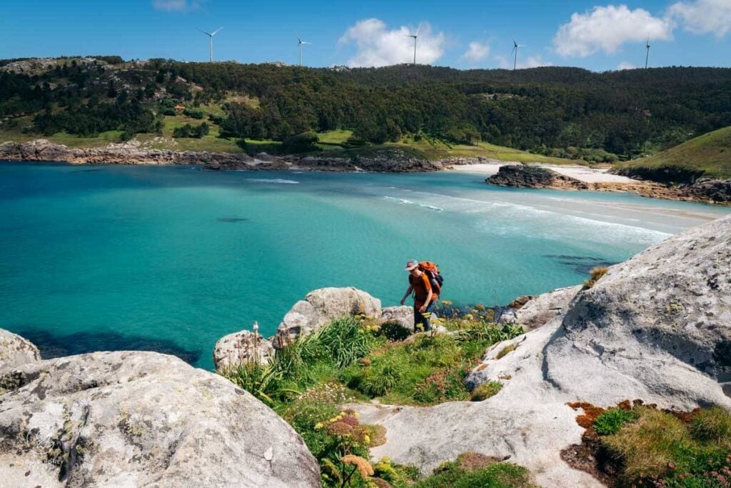
The Camiño dos Faros, or Way of the Lighthouses, is one of Europe’s most exhilarating coastal village-to-village hikes. Stretching 200 kilometers along Galicia’s remote Costa da Morte in northern Spain, it winds across granite cliffs, windswept beaches, and sculpted dunes, connecting historic lighthouses and fishing villages. Its foreboding nickname, the “Coast of Death,” reflects centuries of shipwrecks along this rugged Atlantic shoreline.
Unlike many long-distance trails, the Lighthouse Way rarely strays inland, hugging the coast with a stubbornness that commands admiration. Tracing pathways that are still used by fishermen and percebes (goose barnacle) harvesters today, this Spanish hike feels both epic and intimate.
The full trek is typically divided into 8 demanding stages, though it can easily be adapted with taxi transfers, shortcuts, or shorter sections.
Read my guide to trekking the Camiño dos Faros and where to stay along the Camiño dos Faros to start planning your Lighthouse Way adventure.

After completing the trail and hearing from readers, it became clear that professional planning, route customization, and logistics like luggage transfer can make the experience far more accessible.
That’s why we recommend On Foot Holidays, a highly regarded UK-based specialist in self-guided walking trips. They handle accommodations, luggage transfer, airport/city transfers at both ends of the route, optional taxi shortcuts to ease harder stages, and provide a superb offline navigation app. They offer multiple itinerary lengths (5, 7, or 10 nights), making the Lighthouse Way achievable for a wider range of walkers.
Exclusive offer: New customers can receive a £20 voucher on any tours by using coupon code M&H20 when booking with On Foot Holidays.
12. Alpstein High Trail, Switzerland

The Alpstein is a dramatic limestone massif in the Appenzell Alps in northeastern Switzerland. This U-shaped hiking route runs along the high trails of the Alpstein mountains, starting in Wasserauen and ending in Hoher Kasten, Brülisau.
This adventurous high trail strings together the most iconic landscapes and attractions in Appenzellerland including Lake Seealpsee, the Aescher mountain inn, Ebenalp, the Schäfler mountain inn, the Schäfler ridge, the Altenalp Towers, Mount Säntis, Lisengrat ridge, the Rotsteinpass mountain inn, the Zwinglipass Hut, the Saxer Lücke saddle, the Kreuzberge viewpoints, Staubern mountain inn, and the Hoher Kasten summit.
Exclusively following white-red-white trails, this alpine hike is a great option for surefooted, fit mountain hikers who enjoy ridge paths and limestone terrain (uneven surface, scree, loose rocks, etc…).
If you’re eager to explore the Appenzell Alps on a longer hut-to-hut hiking tour, check out the Swiss Whiskey Trek (moderate), 8-Day Hut to Hut in Appenzell Alps Standard Itinerary (moderate), an 6-Day Hut to Hut in Appenzell Alps Active Itinerary (difficult).
Starting Point | Wasserauen near Appenzell village.
Ending Point | Hoher Kasten, Brülisau
Duration | 3 Days
Distance | 33.5 km point-to-point
Difficulty | Moderately Difficult
When to Hike | June – October
Accommodation | Mountain Huts
Learn More: Alpstein High Trail
13. Montafon Hut-to-Hut Circuit, Austria

The Montafon hut-to-hut circuit (Montafoner Hüttenrunde) is a 13-stage hiking trail that traverses the mountain ranges around Montafon Valley in Vorarlberg.
With soaring 3000+ meter glaciated peaks, verdant river valleys, and idyllic alpine pastures, there’s something truly classic and quintessential about this European trek.
We hiked 5-stages of the route, starting at the Silvretta Bielerhöhe mountain pass (accessible by bus from Schruns) and ending in Latschau (Tschagguns).
If you’re new to hut to hut hiking in Austria, read our comprehensive Austria hut to hut hiking guide.
Where to Stay Before/After the Trek | TUI Blue Montafon (budget), Gasthof Löwen (midrange), or Amrai Suites (luxury) in Schruns-Tschagguns
Starting Point | Silbertal, Montafon
Ending Point | Tschagguns-Latschau, Montafon
Duration | 13 stages which can be hiked in 11 days
Distance | 133 km u-shaped circuit
Difficulty | Moderately Difficult
When to Hike | July, August, September
Accommodation | Mountain Huts. Camping is forbidden.
14. Venediger High Trail, Austria

The Venediger High Trail (Venediger Höhenweg) is a multi-day trek through the Venediger Group in Austria’s Hohe Tauern National Park.
This East Tyrolean hut to hut hike partially wraps around Grossvenediger, Austria’s second-largest mountain, delivering views of mammoth mountains, melting glaciers, and countless waterfalls.
The scenery is impressive in a vast and bleak type of way. On some stages, it feels like you’re hiking into the heart of Mordor. On other days, you feel like you’re hiking on the spine of a dragon.
Starting Point | Virgental Valley
Ending Point | Matreier Tauernhaus in Gschlöß Valley
Duration | 6 Days
Distance | 56 km point-to-point
Difficulty | Moderately-Difficult / Difficult
When to Hike | July – mid-September
Accommodation | Mountain Huts
15. Rosengarten Catinaccio Traverse, Dolomites, Italy

This 3-day trek across the Catinaccio/Rosengarten range takes in the stunning Vajolet Towers, the Santner Klettersteig (optional), and some of the most picturesque mountain huts in the Dolomites in northeastern Italy.
We’d label this trek as moderate (moderately difficult depending on experience), though it certainly encompasses some very easy stretches.
Each day is on the shorter side, so you have ample time to take breaks and savor the views along the way. You can also make this a 2-day trek, with one overnight in the Tierser Alpl Hut.
Starting Point | Carezza/Karersee. We stayed in Hotel Alpenrose (where we stayed).
Ending Point | Passo Sella/Sella Pass.
Duration | 2-3 Days
Distance | 26 km point-to-point
Difficulty | Moderate
When to Hike | Mid-June – Mid-October (weather depending)
Accommodation | Mountain Huts. Camping is forbidden.
16. Karwendel High Trail, Austria

The Karwendel High Trail in Tyrol is one of the best hut-to-hut hikes in the Austrian Alps.
Each mountain hut (Hütte) along this route impressed us with their hospitality, cuisine (especially Pfeishütte, Solsteinhaus, and Nördlinger Hütte), and overall organization and communication. These huts are the crème de la crème of Tirol.
In 6-days, hikers will conquer 63 km and 7000 meters of elevation gain/loss. You’ll walk along rivers, in forests, to peak summits, on balcony trails, and across mountain slopes.
The alpine views and wildlife sightings are consistently sublime. Walls of limestone tower above narrow forested valleys. Families of chamois gallop down slopes of scree. And, distant alpine ranges – Stubai Alps, Zillertal Alps, and the Wetterstein Mountains – entice you from afar.
When evaluating where we’ll take our friends on a hut-to-hut route, the Karwendel High Trail is always one of our top choices.
Where to Stay Before/After the Trek | Lifestylehotel dasMAX (budget), Princess Bergfrieden (midrange-luxury), Summit Seefeld (midrange-luxury) in Seefeld in Tirol
Starting Point | Scharnitz
Ending Point | Seefeld in Tirol
Duration | 6 Days
Distance | 63 km u-shaped circuit
Difficulty | Difficult
When to Hike | July, August, September
Accommodation | Mountain Huts
17. Schladminger Tauern High Trail, Austria

The Schladminger Tauern mountains are a subrange of the Austrian Central Alps and are located in the states of Salzburg and Styria (Steiermark).
Virtually unknown to anyone outside of the German-speaking world, this secret European hiking destination shouldn’t be overlooked.
There are two compelling reasons why you should hike the 5-day Schladminger Tauern High Trail. First, alpine lakes. Along the Schladminger Höhenweg, you’ll pass numerous pristine alpine lakes including Giglachseen and Landwirseen.
The most impressive water-abundant destination along the route is Klafferkessel, a cirque containing more than 30 lakes.
Second, cuisine. The food in the mountain huts is DELICIOUS, especially at Keinprechtshütte and Preintalerhütte.
Starting Point/Ending Point | Stay in TUI BLUE Schladming (budget-midrange), or Stadthotel Brunner (luxury) in Schladming.
Duration | 5 Days
Distance | 45 km circuit
Difficulty | Difficult
When to Hike | July, August, September
Accommodation | Mountain Huts. Camping is forbidden.
18. Mount Triglav Trek, Julian Alps, Slovenia

Mount Triglav (2864 m) is the reigning symbol of Slovenia and of the Julian Alps.
Emblazoned on the national flag, the three-headed mountain serves as true north, orienting Slovenians to their mountains and forests.
There are many ascent routes to Mount Triglav: Krma Valley, Vrata Valley, Lake Bohinj, Seven Lakes Valley, and Pokljuka. No matter where you start, the final stretch to the summit entails climbing a via ferrata route.
We hiked the Pokljuka – Mount Triglav route, a 2-day hike with an overnight in Dom Planika pod Triglavom.
The most frequently asked question we get is: can you recommend a guide for climbing Mount Triglav? Yes, we can. I recommend booking the guided 3-Day Best of the Julian Alps Hut-to-Hut with the Mount Triglav add-on (via ferrata equipment is provided). The local hiking tour operator Slotrips leads this hiking tour every Monday from July to September. This is a great option for solo hikers as well as friend groups and couples.
The benefit of this tour is that the standard route bypasses the summit of Triglav. So, if you’re traveling with someone who wants to experience a hut-to-hut hike in Slovenia, but not necessarily a via ferrata summit climb, they don’t have to.
Starting Point/Ending Point | Rudno Polje, Pokljuka
Duration | 2 Days, or 3-Days if you book Best of the Julian Alps.
Distance | 26 km out-and-back
Difficulty | Difficult
When to Hike | Late June/early July – September
Accommodation | Dom Planika pod Triglavom
19. Triglav National Park Traverse, Slovenia

Triglav National Park is the largest protected area in Slovenia and encompasses a huge chunk of the Julian Alps (Julijske Alpe). The park’s name is derived from the highest mountain in Slovenia, Mount Triglav (2864 m).
Most hiking trails in Slovenia are LONG (e.g. Slovenia Mountain Trail, Juliana Trail) and require weeks to complete. So, I created this Triglav National Park Traverse that highlights the best of the Julian Alps in just 4 days.
You’ll see the high alpine plateau of Kriških podih, Mount Triglav, the Seven Lakes Valley, Luknja pass and the fairy tale pasture around Planini pri Jezeru.
Though the length of the trail isn’t very long, the terrain is challenging at times and requires some scrambling and a head for heights.
In Slovenia, the line between “hiking” and “mountaineering” is somewhat blurred. In fact, hiking in Slovenia is more adventurous and challenging than anywhere else we’ve hiked in Europe.
You can book this trek across the Julian Alps independently. All the huts are bookable online. However, there are many benefits to booking this 7-day self-guided Crossing the Julian Alps hiking tour with Slotrips. It solves a lot of problems that people have when planning this point-to-point route: getting to the trailhead, extra luggage transfer (to the last night, not during the trek), and the option to climb Mount Triglav with a certified guide.
Bonus perk: you can add on the Mount Triglav summit with a IFMGA licensed mountain guide, who will also bring you all necessary via ferrata equipment.
Starting Point | Vršič Pass, Kranjska Gora
Ending Point | Lake Bohinj
Duration | 4 Days
Distance | 45 km point-to-point
Difficulty | Difficult
When to Hike | July, August, September
Accommodation | Mountain Huts. Camping is forbidden.
Insider Tip | Look for Edelweiss around Kriških podih, but remember picking wildflowers is illegal.
20. Berlin High Trail, Austria

The Berlin High Trail (Berliner Höhenweg in German) showcases the best of the Zillertal Alps in Tirol, Austria. It’s an unforgettable adventure replete with challenging ascents and descents, rustic and grand mountain huts, and unforgettable glacier and lake views.
This high-alpine route takes 8 days, though you can easily customize the route for shorter periods of time.
From the spellbinding views of the Schlegeisspeicher reservoir to the wine collection at Olpererhütte, this Austrian hut to hut hike is like no other.
This trail is best undertaken by experienced hikers, as there are some difficult secured passages along the route and some demanding descents (slippery and exposed). No special equipment is needed.
Starting Point/Ending Point | Stay in Landhotel Rauchenwalderhof (budget), Der Siegeler B&B (budget-midrange), or Alpenhotel Kramerwirt (midrange) in Mayrhofen.
Duration | 8 Days
Distance | 86 km u-shaped circuit
Difficulty | Difficult
When to Hike | July – mid-September
Accommodation | Mountain Huts. Camping is forbidden.
Insider Tip | Try to reserve a private room at Greizer Hütte, because the Lager (dormitory) is incredibly tight.
21. Kamnik-Savinja Alps Trek, Slovenia

Less famous than the Julian Alps, the Kamnik-Savinja Alps are just as beautiful and considerably less visited.
This challenging 4-day hut-to-hut hike across the Kamnik Alps is for intrepid hikers who crave something adventurous and altogether quite spine-tingling. High alpine hiking experience is an absolute must, as this is a no-bullshit trek.
Much of the route is secured and exposed. Wear a climbing helmet and a light backpack. We recommend the Osprey Kyte 36 (for women) and the Osprey Kestrel 38 (for men).
If you want to take in the beauty of the Kamnik-Savinja mountains from a less precarious position, head to the bewitching Logar Valley, or book this Kamnik-Savinja Alps Traverse.
Starting Point | Kamniška Bistrica
Ending Point | Zgornje Jezerkso
Duration | 4 Days
Distance | 25 km point-to-point
Difficulty | Challenging / Experts Only
When to Hike | July, August, September
Accommodation | Mountain Huts. Camping is forbidden.
22. Eagle Walk Lechtal Alps, Austria

The Eagle Walk (Adlerweg in German) is a long-distance hut-to-hut hiking trail that traverses the Austrian State of Tyrol in 33 stages (413 km), from east to west.
The most challenging and possibly the most rewarding stretch of the Adlerweg are the stages in the Lechtal Alps (stages 19-24), the longest range of the Northern Limestone Alps.
Highly experienced alpine hikers should consider this spectacular 6-day trek in Austria.
Starting Point | Boden
Ending Point | St. Christoph am Arlberg
Duration | 6 Days
Distance | 57 km point-to-point
Difficulty | Very Challenging
When to Hike | July, August, September
Accommodation | Mountain Huts
Learn More: Hiking the Eagle Walk across the Lechtal Alps
More Europe Hiking Guides
Hiking:
- 2-day hikes in Europe
- hut-to-hut hiking with kids
- Best Day Hikes in Europe
- Best Coastal Hikes in Europe
Car-Free Hiking:
Europe by the Season:


Pin this Image for Future Trip Planning!
Stay Connected:
Connect with us on Pinterest.
Follow us on Instagram.
Like us on Facebook.
Support Us:
If you love reading our content, you can express your thanks by buying us a coffee via Ko-Fi.


These hikes all look incredible, especially the one in the Dolomites! Bookmarking for when I go to Europe next!
What an inspiring post. I’m specifically looking for new and interesting trails to check out as I travel across Europe and this post is super helpful! I just learned about the Juliana Trail so I love the idea of hiking a shorter piece of it if since I’m not able to do the whole thing this year.
I hiked parts of Rota Vicentina last year and really enjoyed my time there. Portugal is always a great choice for hiking and long walks along the beautiful coastline! Also happy to see a trail in Austria in this list!
Such a great post! I´m from Slovenia and I did most of those mentioned, but got some new inspiration for the Dolomites and Austria. Can´t wait for Spring 🙂
These are such good tips! We started hiking last summer with my boyfriend. So far only in Finland but we are hoping to expand to Europe. The vistas in these places are magnificent!
Thanks for giving me some more great hikes to add to my European travel wish list. I’m actually doing the Fisherman’s Trail this April but I’d love to do either of the Slovenia ones and also do some hiking in the Dolomites.
I love appreciating the different landscapes and nature on vacation. These are stunning! Thanks for sharing!
Great write up. I was lucky enough to do some hikes on a trip to Norway in 2019 which was absolutely stunning. Switzerland and Austria are looking like the next trails to explore. Time to save some more money… Thank you for sharing.
My sister and I shared dinner with these lovely trekkers at a refugio along the AltaVia 1 in 2019. I was super excited to come across their curated list of multi-day hikes as we’re hoping to resume our own adventures in 2022. They’ve saved me a lot of time and narrowed down the options. I know if it’s on their list they’ve personally hiked the miles and stayed in the huts they write about. Thanks ladies, I’ve found at least four trails from your list that deserve more intensive research!
Hi Barb,
So happy to reconnect. Have fun planning your next hiking trip in Europe.
-Sabrina
I finished the Tour du Mont Blanc in September and am hooked! Being from the Midwest/USA, the Alps scenery is amazing, and even beats the Rockies in my opinion. Just found your blog and am excited at the options you describe for alternative, less populous, multi-day trips. Thanks for pulling this together!
Mark
Hi Mark,
So glad you’re here. Yes, the Alps are dazzling. Have fun planning your next multi-day trek in Europe.
Kindly,
Sabrina