Hiking in the Dolomites is an intoxicating outdoor, cultural, and culinary experience. From the tear-inducing beauty of the peaks to the charm and hospitality of the mountain huts, hiking here can easily become an addiction.
After a decade of deeply exploring the Dolomites, I’ve put together this guide to the region’s most incredible lesser-known hikes. Social media would have you believe there are only a handful of trails worth hiking across this vast mountain range, but the Dolomites encompass 26 subranges spanning three Italian regions: Veneto, Trentino-Alto Adige (Trentino–Südtirol), and Friuli Venezia Giulia.
What follows are my favorite discoveries to help you plan a Dolomites hiking trip that feels unique, less scripted, and far from the crowds.
For readers who’ve bookmarked my original “40 Best Day Hikes” guide, I’ve included the full list at the end of this post.

- When to Hike: The best time to hike in the Dolomites is from mid-June until the end of September (October), when trails are mostly clear of snow, Rifugios (mountain huts) are open, and cableways are operating.
- Best Hiking Base in the Dolomites: Val Gardena, Alta Badia, Cortina d’Ampezzo, San Martino di Castrozza, Val di Funes, and Alta Pusteria. Read Where to Stay in the Dolomites in Summer
- Languages Spoken in the Dolomites: Italian, Ladin, and German
- Get the Guidebook: Cicerone Guide: Shorter Walks in the Dolomites
- Itineraries: 5-Day Dolomites Road Trip, 7-Day Dolomites Road Trip, or 10-14 Day Dolomites Road Trip
- Car-Free: How to Visit the Dolomites Without a Car
1. Vallon Popera Hike

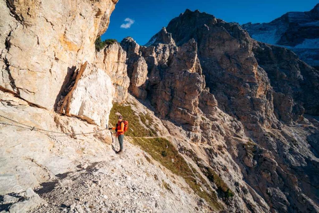
Deep in the Comelico sub-group of the Sexten Dolomites lies one of the most awe-inspiring landscapes in the Dolomites: Vallon Popera. This basin, ringed by jagged, chiseled peaks, is home to Rifugio Berti and the tiny, but bewitching Lago di Popera.
I hiked to Vallon Popera from Kreuzbergpass, which can be easily reached by bus from Sexten. However, it’s also possible to shorten the hike by starting at Rifugio Lunelli.
The most exciting section follows a narrow balcony-ledge across the southeastern flank of Arzalpenkopf. This passage requires comfort with steep drop offs.
For a full trail description, read my Vallon Popera trail guide.
Trailhead | Kreuzbergpass
Distance | 13.3 km circuit
Time Needed | 5:30 hours without breaks
Elevation Gain/Loss | 891 meters
Difficulty | Moderately Difficult
Hiking Base | See Where to Stay in Sexten
2. Steviola Plateau
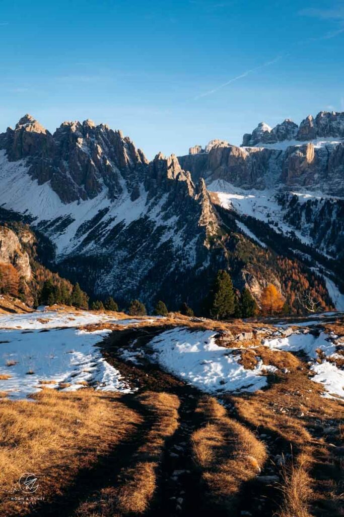
Steviola is a plateau in the Puez Group, high above Selva di Val Gardena. With views of the Sella, Cir, and Sassolungo mountains, this panoramic mountaintop location is one of the best kept secrets in Val Gardena.
From the Daunëi Sciuz bus stop above Selva, two steep, switchback trails, both heavily bolstered with wood, lead to Steviola: trail 17 and Troi Palota (17a).
For the best views, I recommend tackling the route clockwise, initially ascending towards Juac Hütte and then hiking over Silvesterscharte pass to the plateau. For lunch, detour to Juac Hütte or Stevia Hütte.
Find more essential tips in my Steviola hiking guide.
Trailhead | Daunëi Sciuz Bus Stop, Selva
Distance | 6 km circuit
Time Needed | 3:30 hours
Elevation Gain/Loss | 521 meters
Difficulty | Moderate – Moderately Difficult
Where to Stay in Selva | Garni Sunela B&B, Garni Morene, or Garni Hotel Mezdi.
Recommended Itinerary | Val Gardena Summer Itinerary
3. Armentara Meadows Trail
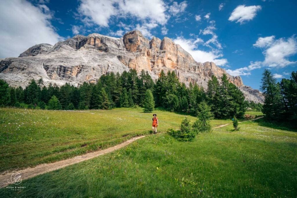
The picturesque Armentara Meadows lie on the western edge of Fanes-Senes-Braies Nature Park in Alta Badia, backed by the immense limestone walls of the Sas dla Crusc massif. This is easily one of the most fairy-tale-like landscapes in the Alps. Fortunately, this trail can be enjoyed in every season, though winter hikers should bring microspikes.
To start the hike, make your way to the village of Badia and ride the two-stage La Crusc gondola up to La Crusc Church. Beside the chapel stands Rifugio La Crusc, serving what many, myself included, consider the best Kaiserschmarrn, a shredded pancake speciality, in the region.
Beneath the arresting rock faces of Mt. Sasso di Santa Croce, trail 15 slowly and continuously descends across rolling green pastures, peppered with hay huts, to Armentara. Enjoy a bite to eat at Űtia Ranch da André and then continue following trail 7a all the way down to Badia (1:15 hours).
Though this hike presents no technical difficulty, it may be difficult for hikers who are uncomfortable with long descents (800 meters loss). Feel free to reverse the trail, descending with the cableway instead.
Trailhead | La Crusc Church
Distance | 9 km point-to-point
Time Needed | 3 hours
Difficulty | Easy
Where to Stay in Badia | Hotel Cavallino (3-star hotel), or Residence Lersc (apartments)
4. Baita Segantini and Monte Castellaz Hike
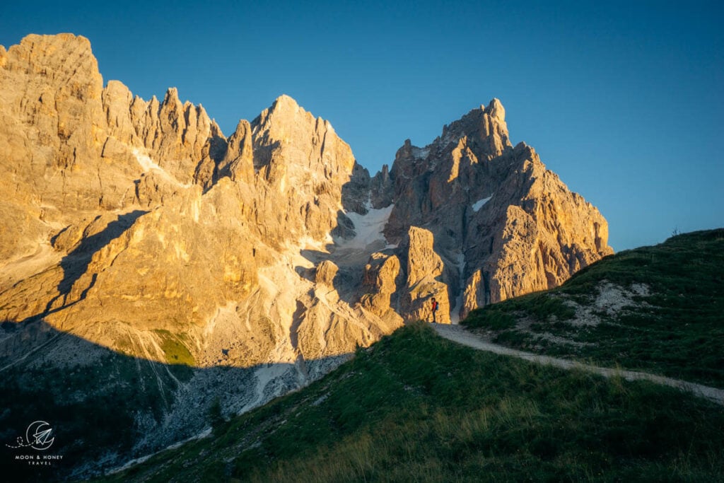
The Pale di San Martino, the largest range in the Dolomites, is frequently overlooked, an unfortunate omission considering its extraordinary beauty. The most accessible way to experience its scale is via the Monte Castellaz-Baita Segantini trail starting at Passo Rolle, high above San Martino di Castrozza.
From the pass, hike to the Capanna Cervino and the continue along the road in the direction of Baita Segantini for about 10 minutes. When you reach a signed intersection, turn left towards the solitary Monte Castellaz mountain. Ascend to the summit, marked by the Cristo Pensante (“Pensive Christ”) sculpture. The drama only crescendoes from here.
The circuit continues down the north flank and then levels across grassy pastures, moving ever towards the mammoth Pale di San Martino peaks. Join the farm road to Baita Segantini and then complete the circuit back to Passo Rolle.
For the best experience, I recommend hiking this trail 3:30-4:00 hours before sunset.
Trailhead | Passo Rolle Car Park
Distance | 9.2 km circuit
Time Needed | 3:30 hours
Difficulty | Easy
Where to Stay in San Martino di Castrozza | Hotel Vienna (midrange), or Sayonara Nature & Wellness Hotel (luxury)
5. Sentiero Viel del Pan and Alta Via delle Cresta

Sentiero Viel del Pan (Viel dal Pan in Ladin, Bindelweg in German) crosses the southern slopes of the Padon chain from Passo Pordoi to Lago di Fedaia, delivering unparalleled views of Marmolada, the highest mountain in the Dolomites.
Since we hiked this trail in the shoulder season, when buses were running less frequently, we chose to complete a circular route. We followed the Alta Via delle Creste along the dark volcanic Padon ridge to Rifugio Viel del Pan, then returned to Passo Pordoi on the gentler Viel del Pan trail.
For an easier option, you can skip the Alta Via trail altogether and instead follow the out-and-back Viel del Pan route to Rifugio Viel del Pan.
This is a fantastic hike to do if you’re driving the Great Dolomites Road.
Trailhead | Passo Pordoi
Distance | 7 km lollipop-circuit
Time Needed | 2:30 hours
Difficulty | Easy
Where to Stay at Passo Pordoi | Hotel Col di Lana (2-star hotel)
Where to Stay in Val di Fassa | Locanda degli Artisti Art Hotel (4-star hotel. See our Locanda degli Artisti hotel review)
6. Lago di Braies to Hochalpenkopf Peak
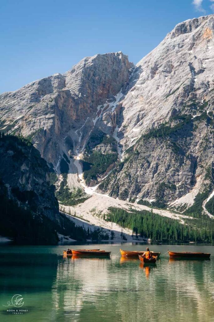
To be honest, Lago di Braies is a shit show these days. But, it’s the starting point of the wonderfully secret Hochalpenkopf hiking trail.
This full-day adventure in the Braies Dolomites leads through Val di Foresta (Grünwaldtal), up to the remote Ütia Fojadora, across high alpine pastures, and ultimately to Hochalpenkopf Peak. The trail ends with a steep but manageable descent back to Lake Braies.
Though this trail presents no technical difficulty, it’s very long (16.9 km total) and requires stamina. In high summer, start as early as possible, so you don’t get scorched in Val di Foresta.
Trailhead | Lago di Braies
Distance | 16.9 km circuit
Time Needed | 8 hours with breaks
Difficulty | Moderate
Where to Stay in Braies/Prags Valley | Garni Bergblick (budget)
Trail Guide: Lago di Braies to Hochalpenkopf
7. Seceda to Monte Pic Hike

There are numerous ways to ascend to Seceda in Val Gardena, including the Ortisei-Furnes-Seceda cableways (pre-booking required), the challenging Resciesa-Seceda route, and the Col Raiser gondola (follow our Seceda-Rifugio Firenze circuit). If you want to skip the cableways, the best way to hike to Seceda is from the Cristauta/Praplan car park above Santa Cristina.
Starting at Cristauta, I recommend ascending to Seceda via Baita Gamsblut and Rifugio Fermeda and then returning via Monte Pic (Picberg), a cone-shaped panoramic mountain that rises above Ortisei and Santa Cristina.
Though I find Seceda astonishing, the highlight of this trail is hiking over Pic to the idyllic Seurasas alpine pastures. On your way down to Cristauta, stop by Baita Seurasas Hütte for a celebratory drink.
Trailhead | Cristauta/Praplan Car Park, Santa Cristina
Distance | 13.9 km circuit
Time Needed | 6 hours
Difficulty | Moderate / Moderately-Difficult
Where to Stay in Santa Cristina | Charme Hotel Uridl (midrange), Dorfhotel Beludei (luxury)
Learn More: Monte Pic Day Hike
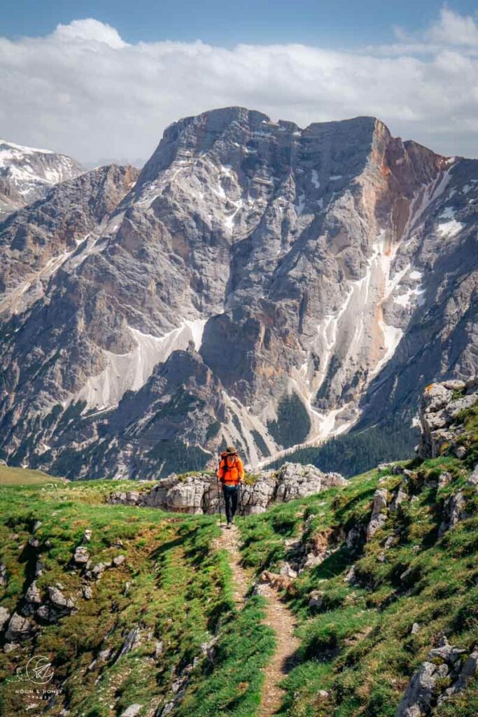
8. Tullen Summit

Tullen (2653 m) is the highest summit in the Odle d’Eores (Aferer Geisler) Group, which borders the Odle Group and Sass de Putia in Puez-Odle Nature Park.
Starting in the Zannes trailhead in Val di Funes, this secret hike ascends the steep Oberer Herrensteig (“Upper Men’s Trail”) and later the Günther Messner Steig to the Tullen summit.
There are so many reasons I love this hike: the solitude, the perspective of the Geisler Peaks, and the incredible high valley trail that leads beneath the bizarre, knob-shaped pinnacles of the Odles d’Eores.
If you’re staying in Val di Funes, I also recommend the Rifugio Genova Circuit Hike. The Adolf Munkel Trail and Santa Maddalena Panorama Trail are famous for a reason, but crowded.
Trailhead | Zannes Car Park
Distance | 12.6 km out-and-back
Time Needed | 7 hours
Difficulty | Moderately Difficult
Where to Stay in Val di Funes | Hotel Fines (midrange)
Trail Guide: Tullen Peak Hike
9. Alpe di Siusi – Rifugio Bolzano – Rifugio Alpe di Tires

Alpe di Siusi (Seiser Alm in German, Mont de Sëuc in Ladin), the largest high-alpine pasture in Europe, is woven with walking and biking trails that crisscross the plateau and climb into the Sassolungo Group, the Catinaccio (Rosengarten) mountains, and the Sciliar (Schlern) massif.
There are countless ways to explore the plateau, but one of the most adventurous routes traverses the pastures of Alpe di Siusi before ascending to Rifugio Bolzano. From there, the trail crosses the Sciliar plateau and descends to Rifugio Alpe di Tires, nestled between the Sciliar and Catinaccio mountains. The final leg returns to Alpe di Siusi via the rugged Forcella Denti di Terrarossa saddle.
This is an ambitious day hike that requires an early start, particularly if you are relying on the Siusi-Alpe di Siusi gondola. For something more gentle, I recommend following our Alpe di Siusi Meadows Trail.
Trailhead | Compaccio
Distance | 21.6 km circuit
Time Needed | 8 hours
Difficulty | Moderately difficult because of the length
Where to Stay atop Alpe di Siusi | Hotel Seelaus (midrange), Hotel Steger-Dellai (luxury), or Alpina Dolomites (luxury)
Trail Guide: Alpe di Siusi – Rifugio Bolzano Circuit
10. Tofana di Rozes Circuit Trail
Tofana di Rozes is one of the most prominent mountains in the Ampezzo Dolomites. I especially love seeing it from Passo Giau, Passo Falzarego, Lago Limides, Rifugio Lagazuoi, Rifugio Nuvolau, Cinque Torri, and many other classic viewpoints around Cortina d’Ampezzo.
Few travelers realize that an exceptional hiking trail circles Tofana di Rozes, beginning at Rifugio Dibona. The loop traverses the mountain’s southern slopes before climbing gradually to the Forcella Col dei Bos saddle. From there, the route continues toward the Travenanzes Valley and then ascends steeply through the rugged Majarié glacial cirque to Rifugio Giussani. The return trail descends from the hut back to Rifugio Dibona along historic World War I paths.
While based in Cortina, d’Ampezzo, I also recommend hiking the Croda da Lago circuit.
Trailhead | Rifugio Dibona
Distance | 11.9 km circuit
Time Needed | 5:30 hours
Difficulty | Moderately Difficult – Difficult
Where to Stay in Cortina d’Ampezzo | Ciasa Vervei (3-star hotel) or Hotel Tofana Cortina (5-star hotel)
Trail Guide: Tofana di Rozes Circuit Trail
11. Gaisl High Trail
Starting atop the Prato Piazza plateau above Braies Valley, the Gaisl High Trail traverses the northern slopes and cirques of the Croda Rossa d’Ampezzo (Hohe Gaisl) massif in Fannes-Sennes-Braies Nature Park.
This trail moves through a shifting tapestry of landscapes, from gentle, serene stretches to more dramatic, intimidating terrain. Most of the hike is quite moderate, but there is one secured passage which may be troublesome for those that dislike exposure and narrow ledge paths.
Ambitious hikers can add on the Strudelkopf summit hike (+2 hours).
Starting Point | Prato Piazza Car Park
Ending Point | Ponticello
Distance | 12 km point-to-point
Time Needed | 4:10 hours
Difficulty | Moderately Difficult
Where to Stay in Braies/Prags Valley | Moserhof Agriturismo Refugium (budget)
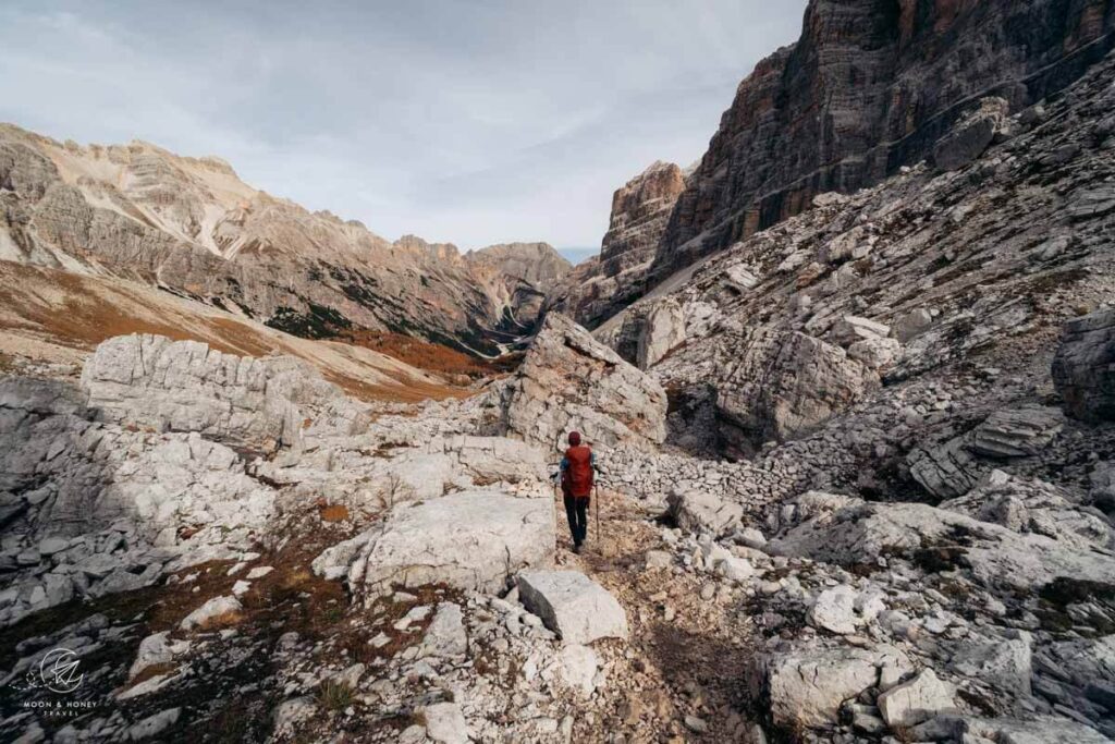
12. Torre dei Scarperi Circuit Trail

The hike around Torre dei Scarperi (Schwabenalpenkopf in German) is the most exciting approach to Tre Cime di Lavaredo in the Sexten Dolomites. This is the best alternative to the Tre Cime di Lavaredo Circuit Trail, but significantly more difficult.
The trail leads through Val Campo di Dentro (Innerfeldtal in German), a side valley of Sexten, and then ascends the western flank of Monte Mattina (Morgenkopf) to reach the narrow Passo Grande dei Rondoi saddle. After a short secured scramble, the path crosses the grassy Schwaben Alm.
To detour to Rifugio Locatelli, skirt the Torre di Toblin (Toblinger Noten) and hug the base of Sasso di Sesto (Sextener Stein). The well-graded descent to Val Campo di Dentro is spectacular, but also long. The trail hugs the eastern flank of Monte Mattina/Morgenkopf (trail 105) and rejoins the valley trail to return to Rifugio Tre Scarperi / Drei Schuster Hütte.
Trailhead | Antoniusstein Car Park
Distance | 16.7 km lollipop-circuit
Time Needed | 6:20 hours
Difficulty | Moderately Difficult
Where to Stay in San Candido | Where to Stay in San Candido including Naturhotel Leitlhof (luxury)
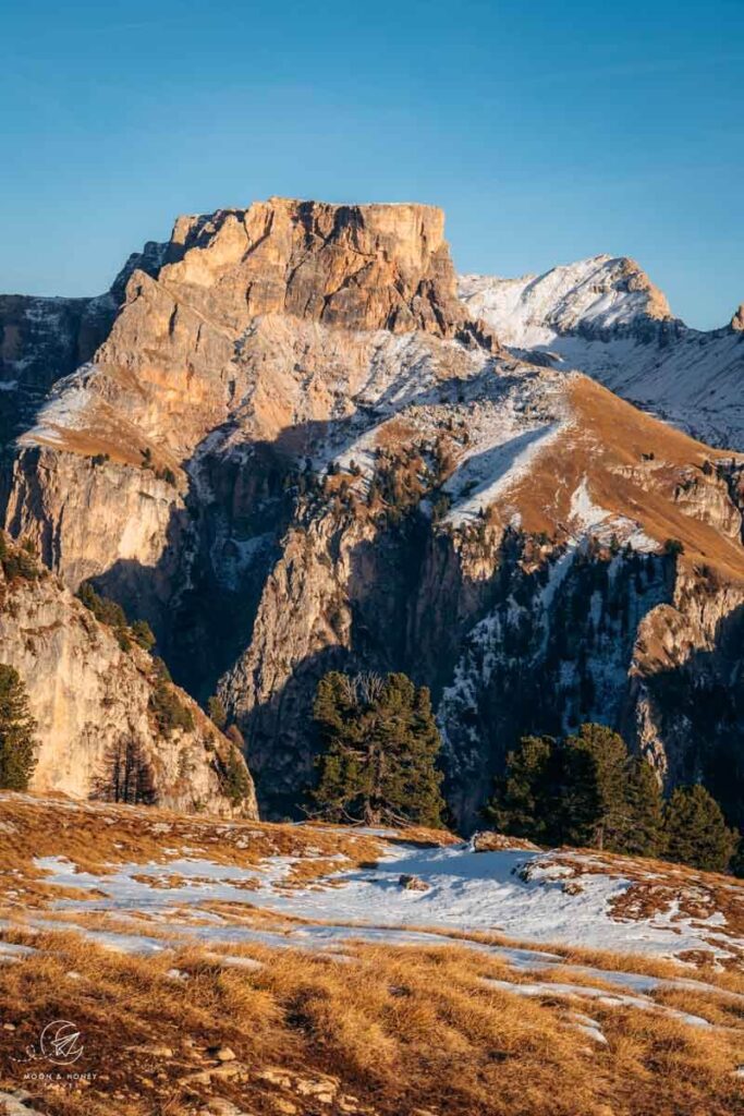
13. Col dala Pieres Summit Hike

Highly experienced hikers who are comfortable with exposure and seeking a challenge will love the Col dala Pieres hike in Val Gardena.
This adventurous summit route begins with the Col Raiser gondola ascent. From the mountain station, the trail meanders across stone-pine studded meadows, where Haflinger horses graze, to Rifugio Firenze (Regensburger Hütte).
From there, a steep, timber-reinforced, rock-strewn trail climbs to Forcella Piza (Pizascharte). After cresting Mount Stevia, hikers can either detour to Stevia Hütte or continue directly toward Col dala Pieres.
From the summit, the route becomes even more demanding. The descent to Forcella Forces de Sieles involves sections of scrambling and sustained exposure, but the rewards are extraordinary, including mesmerizing views of the Geisler Peaks. Beyond the pass, the trail gradually eases as it returns to Rifugio Firenze.
Also consider the hike to Piz Duleda, another peak in the Puez Group.
Trailhead | Col Raiser Gondola mountain station
Distance | 13.7 km circuit
Time Needed | 6 – 7 hours
Difficulty | Difficult
Where to Stay in Santa Cristina | Smart Hotel Saslong (budget), Charme Hotel Uridl (midrange), Dorfhotel Beludei (luxury)
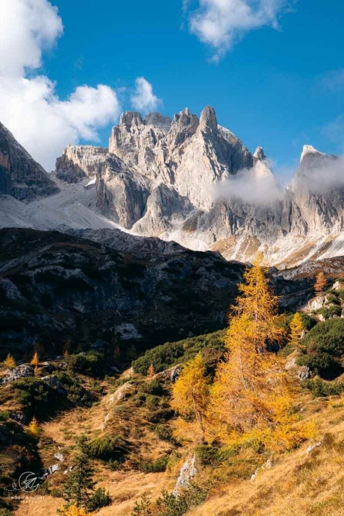
14. Val Venegia to Rifugio Mulaz

The hike from Val Venegia to Rifugio Mulaz is remarkably diverse, weaving together idyllic alpine pastures, rolling meadows, dreamy valleys, larch forests, and soaring dolomite spires.
This memorable Trentino hike begins with an easy walk through Val Venegia to the Malga Venegiota alpine pastures, where the ascent to Passo Mulaz and Rifugio Mulaz begins in earnest.
From Rifugio Mulaz, the loop continues across Passo dei Fochet and Passo di Venegiota, revealing an ever-changing panorama of the Pala Group, Civetta, and countless surrounding peaks. Few trails showcase the sheer variety and grandeur of the Dolomites quite so beautifully.
Trailhead | Malga Venegia
Distance | 12.6 km lollipop-circuit
Time Needed | 6:30 – 7 hours
Difficulty | Moderately Difficult
Where to Stay in San Martino di Castrozza | Hotel Vienna (midrange), or Sayonara Nature & Wellness Hotel (luxury)
Learn More: Rifugio Mulaz Circuit Hike
15. Pala di San Martino Circuit Trail
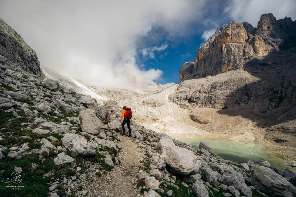
This classic hike circles Pala di San Martino, one of the defining peaks of the central Pala Group (Pale di San Martino). It’s an unforgettable route for hikers like me who want to feel intimately connected to the mountains: hands on rock, moving through rugged alpine terrain rather than simply admiring it from afar.
The trail traverses difficult terrain and requires surefootedness, scrambling ability, and comfort with exposure. One of the route’s highlights is a lengthy secured passage along an exposed ledge. While via ferrata equipment is not essential, I recommend wearing climbing gloves, as they make gripping the steel cables far more comfortable. Of course, feel free to bring a via ferrata kit for additional security and peace of mind.
From San Martino di Castrozza, take the Col Verde gondola followed by the Rosetta cable car to the Altopiano delle Pale di San Martino, a vast lunar-like karst plateau. I recommend hiking the Pala di San Martino circuit counterclockwise, following signs toward Passo di Ball. Along the way, eat lunch at Rifugio Pradidali before continuing deeper into the rocky heart of Pale di San Martino.
Trailhead | Rosetta Cableway mountain station
Distance | 12.1 km Circuit
Time Needed | 6 hours
Difficulty | Difficult and technically demanding
Where to Stay in San Martino di Castrozza | Hotel Vienna (midrange), or Sayonara Nature & Wellness Hotel (luxury)
Dolomites Hiking Map
Each trail mentioned in this guide is displayed on the map. If you click the trail, you can directly access the respective trail guide.
HIKING REGIONS
Val di Fassa
Val d’Ega
Original List of 40 Hikes
I’ve caused some confusion by updating this hiking guide from “40 Best Day Hikes in the Dolomites” to “15 Best Hikes in the Dolomites.” Let me explain. Increasingly concerned about overtourism in the Dolomites, it’s my goal to help travelers discover beautiful hikes beyond the tired instagram-hotspot trail. By showcasing 15 of my absolute favorite (mostly quiet) trails, my hope is that it’s easier to decide where to hike when you want to lose the crowds.
Easy
- Val Fiscalina Walk
- Armentara Meadows
- Baita Segantini and Monte Castellaz Hike
- Santa Maddalena Panorama Trail
- Seceda to Rifugio Firenze Hike
- Adolf Munkel Trail Guide
- Tre Cime di Lavaredo Circuit Day Hike
- Monte Specie Hike
- Sentiero Viel del Pan
- Cadini di Misurina Viewpoint Hike
- Hans and Paula Steger Trail
- Alpe di Siusi Meadows Hike
Moderate
- Lago di Braies to Hochalpenkopf
- Sassolungo Circuit Trail
- Vallunga and Val de Chedul
- Passo Giau to Monte Mondeval
- Monte Pic Day Hike
- Rifugio Genova Day Hike
- Sass de Putia Trail Guide
- Rifugio Puez – Rifugio Gardenacia Day Hike
- Sass da Ciampac Hike
- Rifugio Nuvolau and Cinque Torri Hike
Moderately – Difficult
- Lago di Sorapis Trail Guide
- Tullen Peak Hike
- Alpe di Siusi – Rifugio Bolzano Circuit
- Croda da Lago Circuit Trail
- Tofana di Rozes Circuit Trail
- Gaisl High Trail
Difficult
- Torre dei Scarperi Circuit Trail
- Resciesa to Seceda Day Hike
- Col dala Pieres Trail Guide
- Cima Pisciadù Hiking Guide
- Vajolet Towers
- Rifugio Mulaz Circuit Hike
- Rifugio Rosetta to Rifugio Pradidali Hiking Guide
- Capanna Alpina – Rifugio Fanes – La Villa Hike
- Cima della Vezzana Hiking Guide
Sentiero Attrezzato Hikes: These hikes are semi-secured with fixed cables and other climbing aids. A Sentiero Attrezzato is something between a regular hiking trail and a via ferrata. Though in most cases a full via ferrata kit isn’t necessary, a climbing helmet is advised.
Via Ferrata Hikes


Pin this Image for Future Trip Planning!
Stay Connected:
Connect with us on Pinterest.
Follow us on Instagram.
Like us on Facebook.
Support Us:
If you love reading our content, you can buy us a coffee via Ko-Fi.


First, your blogs are perfect and are really helping plan my last minute hiking trip to the Dolomites! Thank you!
Do you think it would be smart/worth it to combine the yellow Seceda hike and the Blue Col dala Pieres one if you stayed at the Rothenberg hut over night? Plan to go September 4/5 or 5/6 depending when I get there.
Thank you!
Hi Brytani,
Thank you! Yes, I would absolutely recommend doing both of those hikes, with the overnight in Regensburger Hütte. Have a great trip!
-Sabrina
Amazing!! Planning to go there this summer and will make sure to add some on my list. Always hard to decide which hikes to do!!
Hi,
Thanks for writing a beautiful blog about the hike. One question, you mentioned the best time to hike dolomites is late june until emd september but you also mentioned about done it in May, you didnt specifically talk about hiking early in June. I have planned 1 week stay in dolomites area between first – second week on June. Do you think hiking —> sorapiss, seceda, tre cime, braie are good idea during that time? I
Thank you so much!
We visited the Dolomites in early May and there was so much snow/rain, we weren’t able to hike. Unless you’re hiking primarily in the valleys, May is not a good time to hike in the Dolomites.
Depending on the length of the winter, you may encounter snow on the trails in early June. I’d bring hiking poles and crampons to be on the safe side.
Note: Many Rifugios (mountain huts) open in late June. So, for example, all the huts along the Tre Cime di Lavaredo Circuit will likely be closed until the third week of June.
Let me know if you have more questions,
Sabrina
This is so amazing! I visited the Dolomites for the first time this summer. We did two weeks in a camper van, and I still feel like I barely scratched the surface of all the amazing places to see. I can’t wait to get back this summer! Thanks for sharing!
Thanks Marissa! We always leave feeling like there’s so much more to still see.
Happy planning,
Sabrina
Hi Sabrina & Kati,
Thank you so much for putting together such a wonderful guide! You’ve been my go-to resource for my upcoming Dolomites trip in July.
All of the hikes here look incredible and so now I’m having the most difficult time picking which to do. We’ll have 5 days in Alta Badia and Val Gardena, so if you could only pick 5 of the following, which would you recommend?
+ Mont Pic + Seceda
+ Col dala Pieres
+ Sassolungo – Langkofel circuit
+ Sass de Putia
+ Adolf Munkel
+ Armentara Meadows
+ Alpe de Suisi
Thank you!
Hi Paige,
You’re very welcome.
1. Mont Pic + Seceda
2. Col dala Pieres
3. Sass de Putia circuit (in the morning)… Adolf Munkel Trail (in the late afternoon)… It’s a lot of hiking in one day, but I think you could squeeze both of them in. Plus, Passo delle Erbe isn’t so far from Val di Funes.
4. Armentara Meadows (this is lovely/very easy/short)..you won’t need the whole day for this.
5. Alpe di Siusi.. There are so many routes you can do. If you’re taking the cableway from Ortisei. Follow trail 9 (like we did) to Saltria. But, instead of going to Monte Pana, take the Hans-und-Paula-Steger Weg trail to Compaccio, and then head back to the Ortisei-Alpe di Siusi cableway. You can see these trail connections in our Alpe di Siusi guide.
Hope that helps,
Sabrina
I wanted to also voice my appreciation for your very useful Dolomite hiking guides. We were able to do two over the past few days, Monte Pic/ Seceda and Adolf Munkel., which I picked based on the map provided, which allowed us to select hikes which were within reasonable driving distance of where we were staying.
Our first hike was really only to the Seceda summit and back; we ran out of time ( and energy) on a cool overcast October day. I’m not too sure about the accuracy of the time estimates for that one, it took us about 4 hours for the ascent rather than the 2hrs 35 minutes predicted. After the first leg there are many crisscrossing small roads and trails, with confusing or non existent signage, so perhaps we went off course in spots. We thought that the better advice after completing the first leg might be “ look up, find the cable car lift line that goes to the top, and use whatever trail(s) seems to visually suit your fitness level. Having said that, the view at the top was stunning and made the effort very worthwhile.
Something we didn’t realize until just now, a couple of days later, that the Munkel trail features the same set of mountains, from the opposite side and a different angle. So our hikes were not very far away as the crow flys but almost a couple of hours ( I think) driving distance between the respective trail heads. Quite fascinating and unexpected.
We look forward to trying out future hikes you have suggested, in the event we get back in the region.
Hi Paul,
Thank you for the feedback! I’m happy to hear that you enjoyed the Seceda hike, despite it being longer than you anticipated. We always rely on Maps.me to help with orientation/navigation. You may find that app helpful. The Odle/Geisler Peaks are beautiful from so many different vantage points. Next time, you should consider the hike to Col dala Pieres – that’s my particular favorite view of the Geisler Group.
All the best,
Sabrina
Hi Sabrina,
Thank you for this great guide.
We are traveling with twins 10 y/o and will be in the dolomites around mid July.
We wonder if any of the moderate trails suitable since the length of most of the hikes are very similar.
I guess with kids the duration of the hikes is different and a bit longer.
We’ll be staying in Santa Christina for a week and wanted to ask for a recommendation for the most suitable hikes with kids… or which ones should we avoid …
Thank you!
Hi Shoval,
I would check out these kid-friendly hikes in the Dolomites:
Val Gardena
– Seceda to Rifugio Firense/Regensburger Hütte (since you’re based in Santa Cristina, you can also take the Col Raiser Gondola up to start this circuit)
– Alpe di Siusi – you can hike all over the plateau. There are lots of options.
Val di Funes
– Adolf Munkel Trail
– Rifugio Genova Circuit Trail
Pass delle Erbe
– Sass de Putia Circuit Trail
Alta Badia
– Armentara Meadows
– Sass da Ciampac – you could do a variation of this. Since you’re based in Val Gardena, you could take the Dantercepies cableway from Selva to Passo Gardena and hike to Rifugio Puez via Forcella Cier and Forcella de Crespeina. When you get to Rifugio Puez, you’ll complete the circuit to Selva di Val Gardena via Langental/Vallunga valley.
All the best,
Sabrina
Hi Sabrina,
Thank you for this incredibly thorough guide and map! My wife and I are experienced hikers visiting the Dolomites for the first time June 7th for 2.5 days, staying in Badia. With 2 long hiking days, and one half day, I am curious what your absolute must-dos would be, within reasonable distance to Badia.
It seems like one day we might be able to combine Adolf Munkel with Sass de Putia or Seceda Ridgeline and the other day Tre Cime with Lago Sorapis or Croda da Lago, leaving the half day TBD.
So many amazing options! Greatly appreciate your guidance.
Taylor
Hi Taylor,
If you’re based in Badia, I would do the Sass de Putia circuit trail with the Sass de Putia summit. The final stretch to Sass de Putia peak is secured with fixed cables, but equipment is usually not necessary for confident vertigo-free hikers. The Armentara Meadows are right on your doorstep, which might be the best option for the half-day hike. And for the other full day, I would either do the Croda da Lago Circuit or the Tofana di Rozes Circuit.
All the best,
Sabrina
You guys have the best hiking blog I have come across. I’ll be hiking in Cortina, Alta Badia, and Val Di Funes for 2 weeks later this month. Who makes the best paper hiking maps of these areas? I always like to have paper back ups and not fully rely on GPS. Thanks!
Hi Greg,
Thank you so much! We use the Tabacco maps – which are readily available across the Dolomites.
Have a great trip!
Sabrina
Hello, I am travelling to the Dolomites in July and your blog has been SO helpful in my planning, so thank you!
I will be spending a week there (3 nights in cortina d’Ampezzo, 3 nights in selva).. I would like to do a 2 day hike in the middle of my trip with an overnight stay at a Rifugio – this will be my first time, do you have any trail recommendations? Thank you!
Hi Laura,
Thank you for reading! I would do this Alpe di Siusi – Rifugio Bolzano circuit trail and overnight in Tierser Alpl. During our first trip to the Dolomites, we stayed in Tierser Alpl and it was unforgettable.
Have a great hiking trip!
Sabrina
Hi, thanks so much for your detailed blogs. We used your Slovenia guide for a fantastic holiday a couple of years ago. This year we’re off to the Dolomites for the first time. Unfortunately due to other commitments we’ll be there the last week of August and first week in September. I say unfortunately as I would rather go later to avoid the crowds. So before I read through every hike, which of these hikes would you recommend to avoid the worst of the crowds? We’ll be in the Dolomites for around 12 days but 3 of those nights we’ve booked the Hotel Paradiso on the Alpe di Siusi. We’ll probably choose another 3 locations to stay 3 nights in each but these locations will be chosen around the hikes we want to do.
Hi Kelley,
Thank you for re-visiting our blog to plan your trip the Dolomites. Here are my favorite off-the-beaten-path and lesser known hikes in the Dolomites.
Alta Pusteria
– Lake Braies – Hochalpenkopf Circuit
– Prato Piazza – Gaisl High Trail
– Torre dei Scarperi Circuit Trail
– Sentiero Bonacossa – this intersects with busy areas, but once you get beyond the famous Cadini viewpoint, it shouldn’t be too busy.
Most of these hikes require extra early starts because of the traffic regulations. It’s all explained in our destination guides.
Cortina d’Ampezzo
-Tofana di Rozes Circuit Trail
Val Gardena
– Vallunga Valley – Val de Chedul Circuit
– Monte Pic to Seceda
– Col dala Pieres or Piz Duleda (choose one)
Val di Funes
– Tullen Summit
Hope this helps!
Sabrina
Hello Sabrina,
We are the group of 15 girlfriends that planning to visit Dolomites in the middle of May in the 1st time. We will only have about 2-3 days for hiking and exploring the beautiful area.
Since there are a big variety of hiking regions and potential limitations to hike due to the season we have a difficult time to pick the hiking region and best possible trails.
Based of our initial research the most accommodating hiking regions would be Val Gardena and Cortina d’Ampezzo…. Can you please recommend the hiking region and potential easy to moderate hikes for 3 days?
Thank you for your feedback ::))
Hi Sabina,
I recommend Val Gardena in May with a day trip to Val di Funes. Please read May in the Dolomites and Val Gardena hikes.
Shorty before your trip, I recommend reaching out to the Val Gardena tourist info office for updates on trail conditions.
Kindly,
Sabrina
Hallo Sabrina,
A group of four friends and I are heading to the Dolomites from September 11th to 18th.
We are driving from Belgium and will stay for the first three nights at Hotel Passo Tre Croci (Cortina), followed by four nights in an apartment in Castelrotto.
Ignaas
Hi Ignaas,
I’m happy to provide a paid review of your itinerary. Please check your email.
Kindly,
Sabrina