Sentiero Alberto Bonacossa is an exhilarating secured hiking trail that runs through the dramatic Cadini di Misurina mountain group in the Italian Dolomites. It connects Rifugio Col de Varda with Rifugio Fonda Savio and Rifugio Auronzo.
The trail unfolds cinematically, as you conquer secured passages, narrow ledges, and steep rocky valleys.
There are a few ways to hike Sentiero attrezzato Alberto Bonacossa (“Aided Path Alberto Bonacossa”). You can hike the trail in its entirety, starting at Rifugio Col de Varda, which you can reach with the Misurina-Col de Varda chairlift. From the mountain station, the trail leads north all the way to the Cadini di Misurina Viewpoint and Rifugio Auronzo. From Rifugio Auronzo, you can return to Lago di Misurina by bus.
Alternatively, you can hike the Sentiero Bonacossa South Route (Rifugio Col de Varda with Rifugio Fonda Savio) or the Sentiero Bonacossa North Route (Rifugio Fonda Savio to Rifugio Auronzo) as loop trails. We’ve hiked both routes on different trips.
What follows is a summary of the thrilling north route circuit.
- Trailhead: Rifugio Auronzo Car Park, or Lago d’Antorno
- Distance: 12.5 km circuit
- Time Needed: 6 hours
- Elevation Gain/Loss: 869 meters
- Difficulty: Difficult
- Minimum Elevation: 1838 meters
- Maximum Elevation: 2346 meters
- When to Hike: July – October, depending on snow conditions.
- Where to Eat: Rifugio Fonda Savio or Rifugio Auronzo
- What to Bring: Sturdy hiking boots, hiking poles, and a climbing helmet.
- Where to Stay nearby: Albergo Chalet Lago Antorno (midrange)
- Recommended Trail Map: Tabacco 010: Sextener Dolomiten/Dolomiti di Sesto 1:25.000
Sentiero Bonacossa North Trail Circuit Map
The Cadini di Misurina mountains are located in the municipality of Auronzo di Cadore in the Italian province of Belluno in Veneto. They form the southernmost mountain group of the Sesto/Sexten Dolomites, a magnificent range which extends into South Tyrol.
Cadini di Misurina is bounded by the Misurina Lake to the west, the Lavaredo Group to the north, the Val Marzon and Vallone di Lavaredo valleys to the East, and the Ansiei valley to the South.
Sentiero Bonacossa Trail Difficulty
Only undertake this route in fair weather. If thunderstorms are in the forecast, please don’t attempt it.
On trail signs, this path is called Sentiero attrezzato (“Secured Path”) Alberto Boacossa. Some guidebooks even describe this path as an easy via ferrata (protected climbing route).
This is a strenuous hiking trail for experienced hikers only. You should be very surefooted, comfortable with exposure, narrow passages, and crumbling Dolomite terrain.
As the name states, there are some secured passages along the route.
It’s imperative to wear a helmet for this hike. Some hiking books even recommend bringing the whole via ferrata kit. We wore climbing helmets and climbing gloves.
Where to Start the Sentiero Bonacossa North Route Circuit
You can start this hike at Rifugio Auronzo or Lago d’Antorno. The best place to start this hike is Lago d’Antorno.
Lago d’Antorno Trailhead
Lago d’Antorno is located between Lago di Misurina and the Rifugio Auronzo – Tre Cime di Lavaredo Toll Road gate. By starting the hike at Lago d’Antorno, you won’t have to pre-book parking at Rifugio Auronzo.
There are two free parking lots near Lago d’Antorno (see map).
If you decide to start this hike at Lago d’Antorno, we suggest hiking to Rifugio Fonda Savio first and then tackling the Sentiero Bonacossa trail south to north. By doing so, you’ll ascend the difficult secured passages.
Rifugio Auronzo Trailhead
We decided to start this Cadini hike at Rifugio Auronzo because we wanted to watch the sunset at the Cadini di Misurina viewpoint after the hike. Also, we wanted to hike the Sentiero Bonacossa Trail north to south, so we could face the Cadini di Misurina peaks throughout the hike.
Given the new traffic regulations that require pre-booking entry to the Auronzo – Tre Cime di Lavaredo toll road, we don’t recommend starting at Rifugio Auronzo.
Toll Road Seasonal Opening Times | Late May/Early June – Late October/Early November, depending on weather conditions.
Sentiero Bonacossa North Trail Description
Here’s a quick summary of the route:
Rifugio Auronzo – Cadini di Misurina Viewpoint | 30 minutes, easy
Cadini di Misurina Viewpoint – Forcella de Rinbianco | 1:30 hours, challenging
Forcella de Rinbianco – Rifugio Fonda Savio | 1 hour, moderately-difficult
Rifugio Fonda Savio – Lago d’Antorno | 1:15 hours, moderate
Lago d’Antorno – Rifugio Auronzo | 1:30 hours, moderate
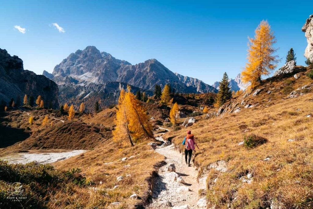
Rifugio Auronzo to the Cadini di Misurina Viewpoint (30 minutes)
Rifugio Auronzo is a high-alpine refuge located at the southern foot of Tre Cime di Lavaredo (Drei Zinnen in German, Three Peaks in English) along the famous Tre Cime di Lavaredo Circuit Trail – one of the most well known day hikes in the Dolomites.
Once you arrive at the Auronzo car park, locate trail 117.
The best way to find trail 117 is by heading first to Rifugio Auronzo. From the hut’s outdoor terrace, walk down the paved steps along the road. Directly at the road, there’s a trail sign guiding you south in the direction of Rifugio F.lli Fonda Savio (Trail 117).
This clear path steers you away from the imposing Tre Cime di Lavaredo and towards Monte de le Cianpedele/Monte Campedelle (2346 m) and the razor-sharp Cadini di Misurina peaks.
The trail initially descends for about 10 minutes to the Forcella Longères saddle. From here, continue straight along trail 117, making a quick counter-ascent across the high plain of Monte de le Cianpedele/Monte Campedelle.
To the east (looking left), you’ll see the deep Vallone di Lavaredo – Valle Marzon valleys and several prominent peaks of the Sesto/Sexten Dolomites. Looking back, the views of the Three Peaks get better and better.
After ascending for a few minutes, the path divides. Ignore the left trail, which is eroding and in poor condition. Head right instead, following the official trail, which is waymarked with mini poles.
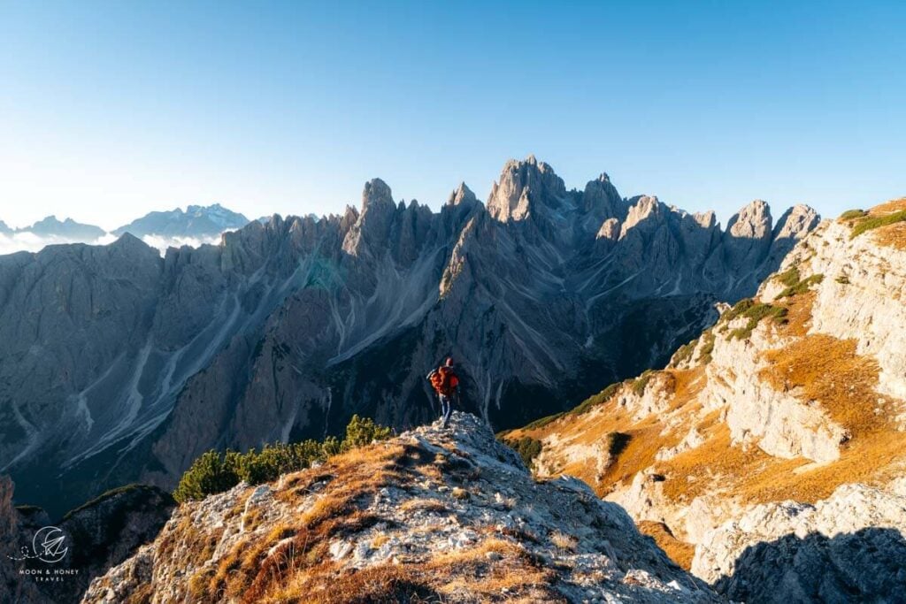
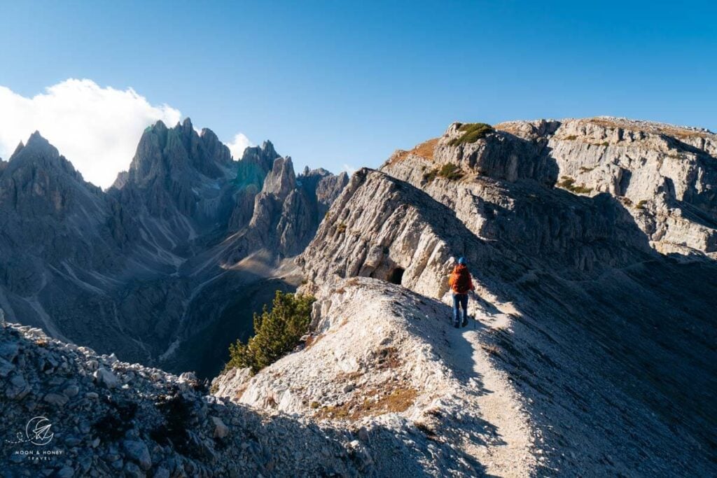
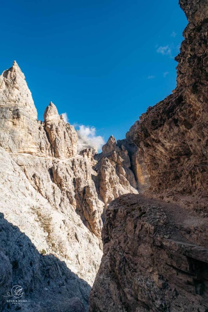
When the trail divides again, about 10 minutes later, take the more scenic left footpath, which skirts the summit of Monte de le Cianpedele/Monte Campedelle. This trail brings you face-to-face with the impressive northern Cadini di Misurina Group, which looks like the imagined backdrop of a high fantasy epic.
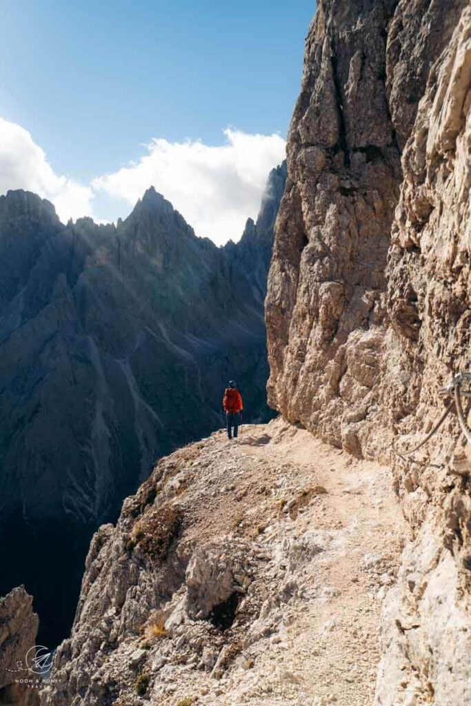
Soon, you’ll see the famous Cadini di Misurina photo spot, which is a grassy ridge sloping upwards and projecting triumphantly towards the Cadini pinnacles. It looks like a small ski jump.
The Sentiero Bonacossa Trail continues along the ledge, steadily towards this impressive viewpoint.
The path to the viewpoint branches off to the left of the main trail.
Cadini di Misurina Viewpoint to Forcella de Rinbianco (1:30 hrs)
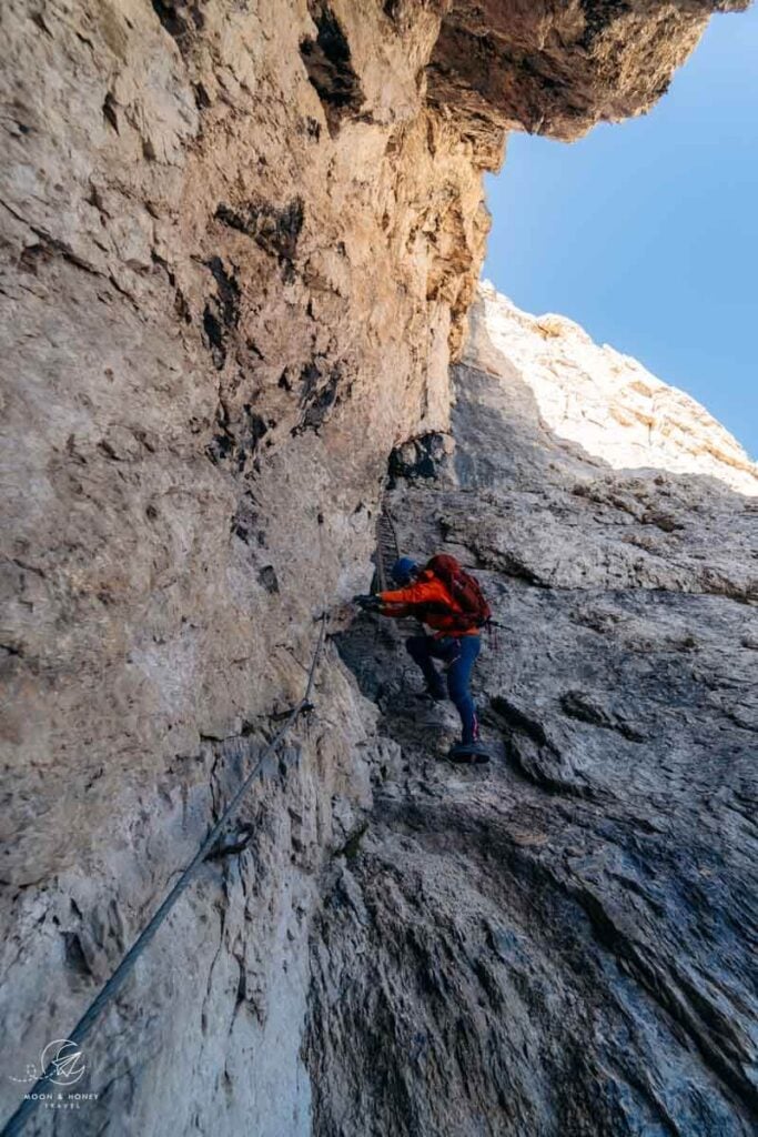
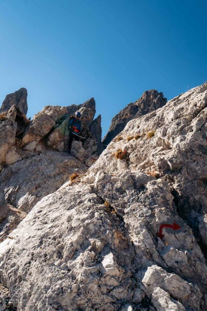
Sentiero Bonacossa continues west. You’ll see a conspicuous white-red painted waymark. Now it’s time to strap on your climbing helmet. Around the bend, you’ll see the first secured passage (steel cables).
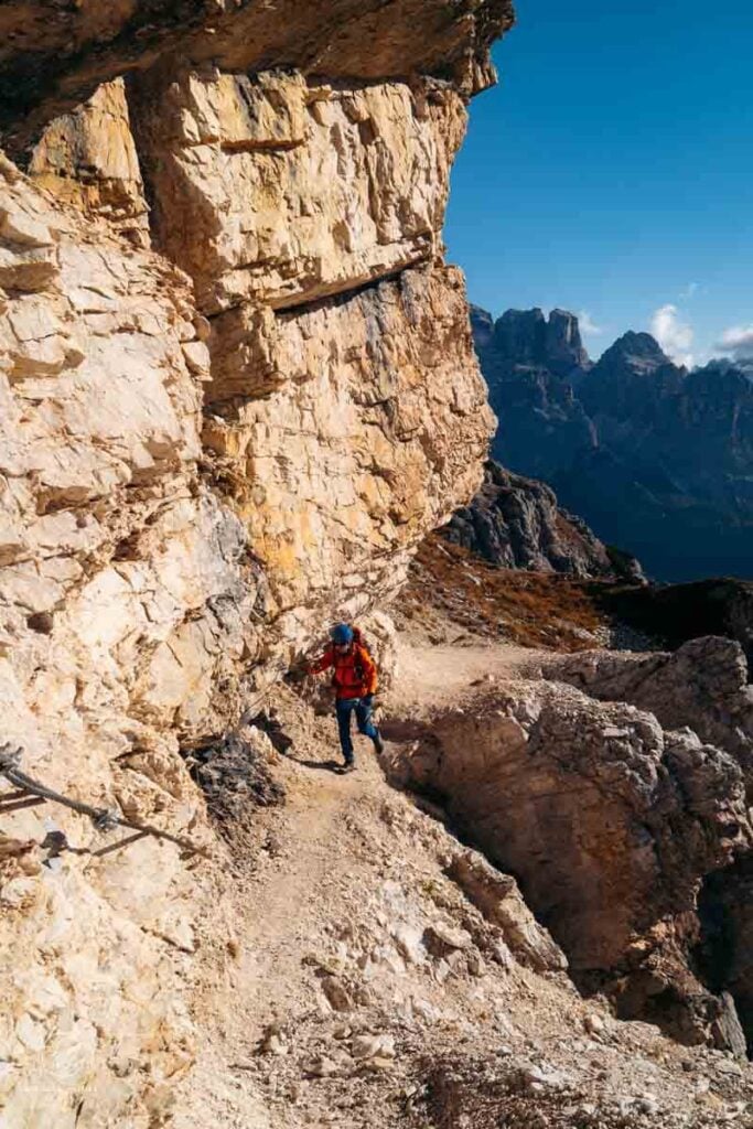
The trail clings to the south face of Monte de le Cianpedelle along a ledge. Looking west, you’ll see Sass de Putia/Peitlerkofel, Croda Rossa d’Ampezzo/Hohe Gaisl, Monte Piana, Croda del Becco/Seekofel, and even Monte Specie/Strudelkopf and Picco di Vallandro/Dürrenstein.
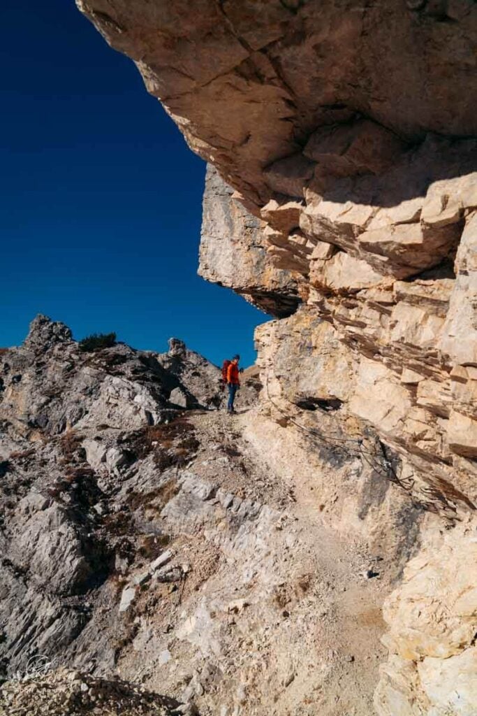
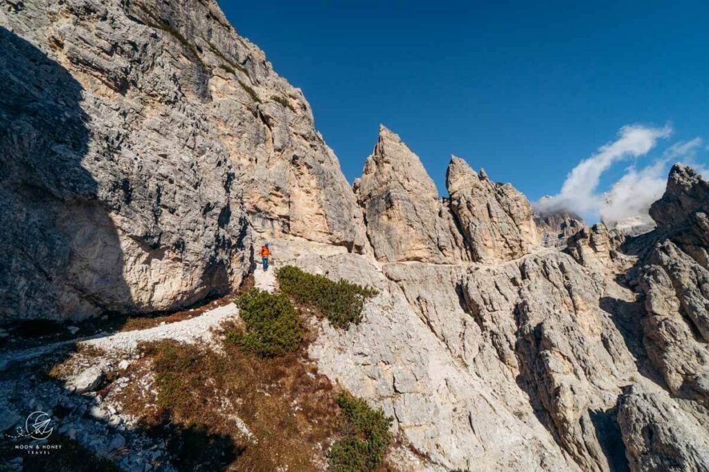
When the trail heads south, you’ll be hiking just below a ridge on a level path towards the Cadini pinnacles. There’s a WWI tunnel on your left.
The path wraps around the mountain on a narrow ledge, which is secured in some places. Cutting horizontally across the vertical rock face, the path looks very intense. However, you’ll find that it’s easy to walk (in dry conditions), provided that you have no fear of heights and you’re confident hiking in scree/loose rocky terrain. All exposed sections are well-secured.
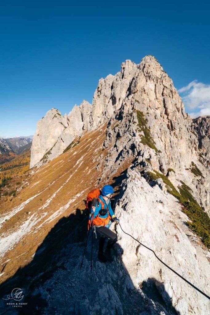
After the ledge, the trail twists down to another short, but steep, secured passage. Looking East, you’ll see prominent Sesto/Sexten Peaks including Croda dei Toni/Zwölferkofel, Cima d’Auronzo, and Punta dell’Agnello.
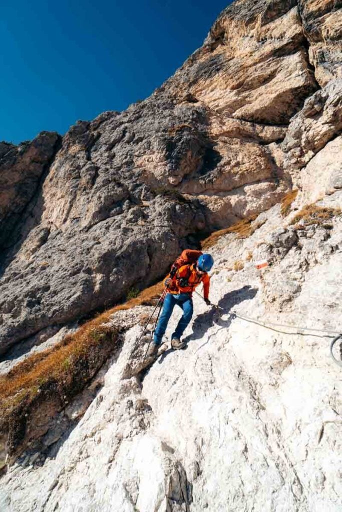
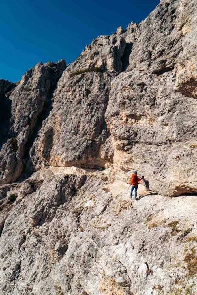
Trail 117 continues to descend a few meters to another secured section which aids you down a 40-meter vertical rock step in the east face of Cima Cadin de le Bisse. This is hands down the most challenging part of the Sentiero Bonacossa northern route. And, this is why most people will hike the route south to north.
The rock underfoot is very slippery due to trickling water and lack of sunlight (rock overhang). Had we brought our via ferrata harness and lanyard, I would have happily clipped in here.
The protected route is initially secured with steel cables and a few pegs. It ushers you to a ladder. Facing the mountain, descend the ladder, grasping the steel cable as needed.
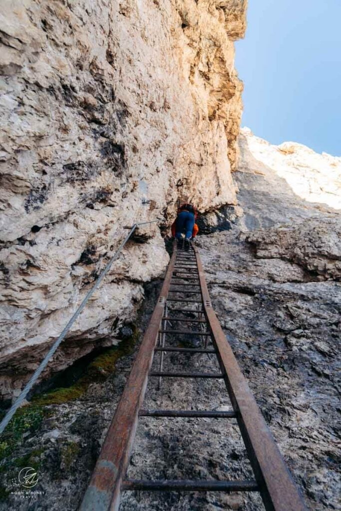
At the foot of the ladder, the slippery and polished rock step continues to be a challenge. More pegs help you find your footing as you navigate this final section.
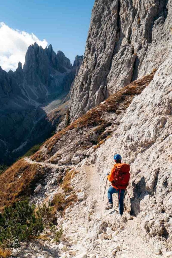
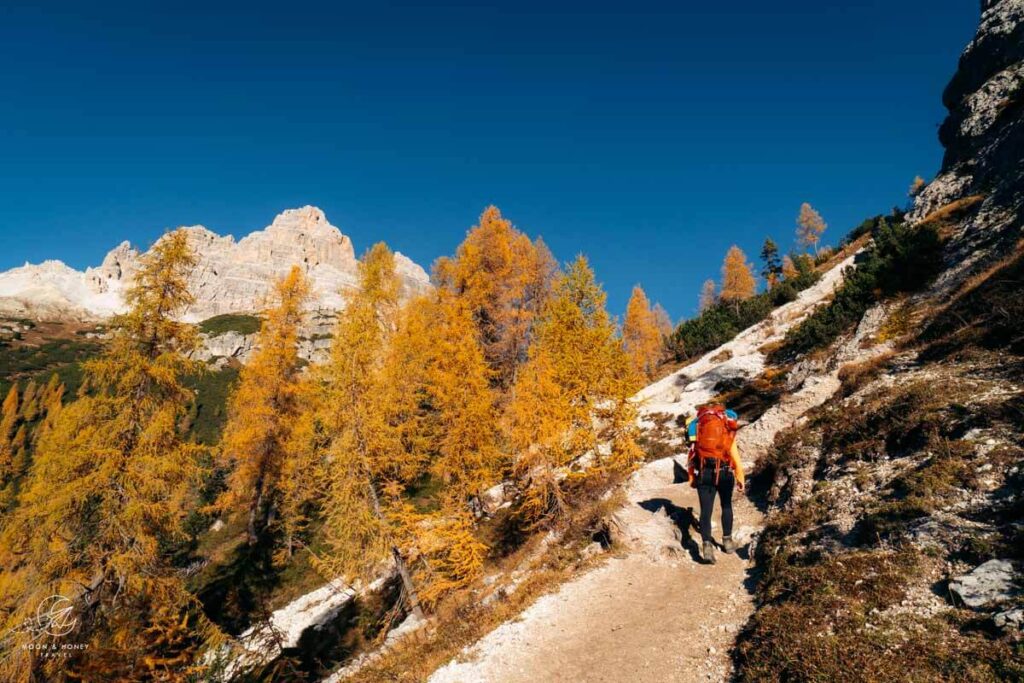
With the hardest part of the trail behind you, continue hiking south along a rocky narrow path, above Val de le Cianpedele valley, towards the Cadini Peaks. The trail continues to cling to the eastern flank of Cima Ciadin de Rinbianco.
After about 30 minutes, the trail ascends steeply to a rocky ridge. You’ll see a waymark, followed by a steel cable. After the cable, hop onto the ridge. Do not follow the exposed footpath on the right that skirts the ridge. Atop the ridge, an easy flat trail awaits you.
You’ll descend a few meters along the ridge and then follow a flat path for a minute or two.
Soon the trail makes a quick ascent followed by a quick descent to the Forcella de Rinbianco saddle.
Forcella de Rinbianco to Rifugio Fonda Savio (1 hour)
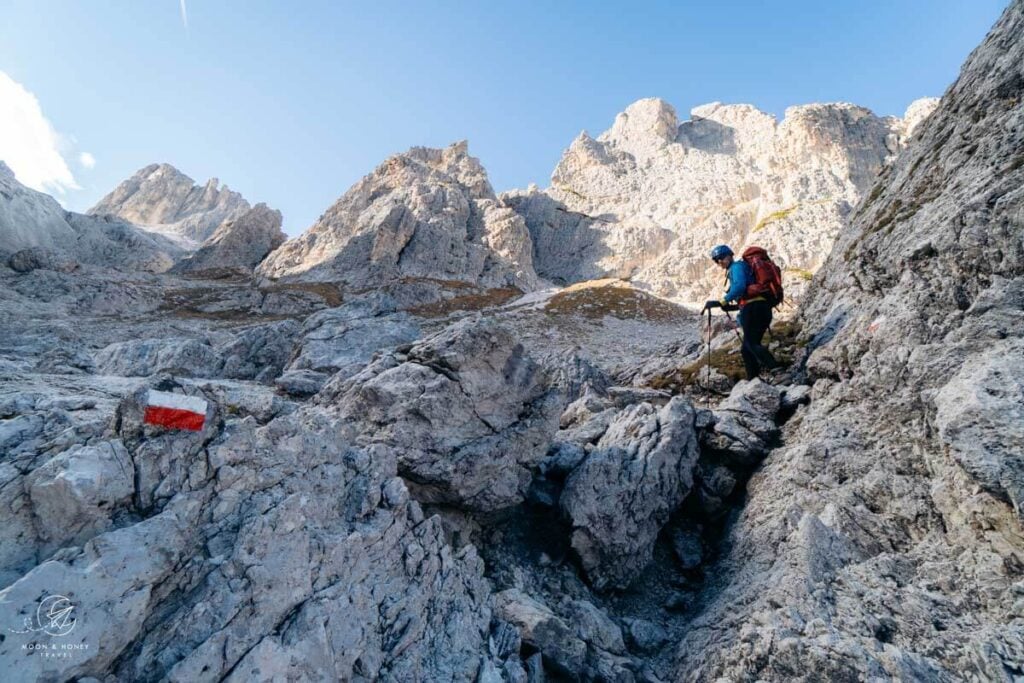
At the signed intersection at Forcella de Rin Bianco (2176 m), head left on trail 117 to Rifugio F.lli Fonda Savio.
If you need to end the hike early, you can descend here along trail 119 through Ciadin de Rinbianco (direction: Casello Pedaggio). This exit route takes you to the Auronzo/Tre Cime toll road station, Lago d’Antorno, and to trail 101 (ascent route to Rifugio Auronzo).
Shortly thereafter, there’s another signed intersection. Keep following trail 117.
An easy, level path guides you across boulder-speckled slopes to Vallon del Nevaio (“Snowfield Valley”). Soon, you’re hiking up the rocky valley, amidst a jungle of stone.
After ascending for about 15-20 minutes up the barren Vallon del Nevaio towards the Cadini peaks (Cima Cadin Nord-Est, Cima Cadin di San Lucano, Cima Eotvos, and Cima Cadin Nord Ovest), you’ll reach a signed intersection. Continue right along 117.
The trail twists up and then through a rocky secured channel. When you emerge, you’re at the base of another secured section.
Head right up the steep rock flank, aided by steel cables and a ladder. You’re only 5 minutes away from the picture-perfect Rifugio Fonda Savio.
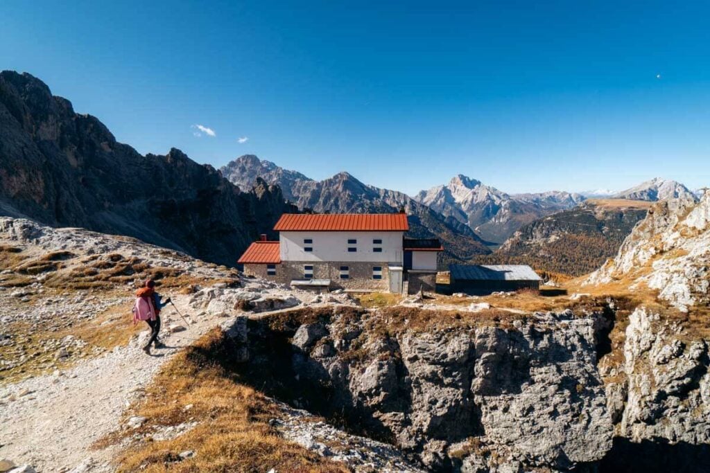
Rifugio Fonda Savio is located at the Passo dei Tocci saddle, between Torre Wundt and Cima Cadin Nord-Est. The hut is also situated at the crossroads between the Sentiero Bonacossa and Sentiero Durissini hiking trails.
Side Note: Rifugio Fonda Savio is the starting point of the Via Ferrata Merlone which leads to the summit of Cima Cadin Nord-Est.
This is a wonderful place to eat lunch. Bring cash.
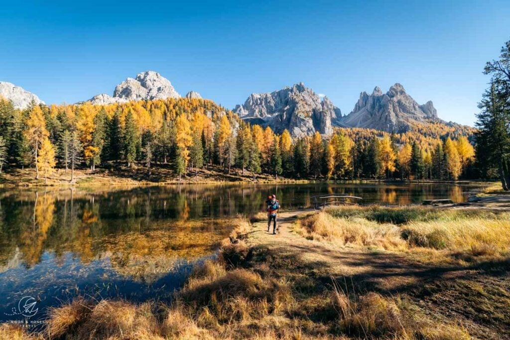
Rifugio Fonda Savio to Lago d’Antorno (1:15 – 1:30 hrs)
From the hut, you’ll descend along the moderate trail 115 all the way to the Misurina-Auronzo road, just south of Lake Antorno.
Though initially secured with cables, most of this track is a breeze.
The trail cuts across the slopes of Torre Wundt and then curves down to a large meadow of the Ciadin dei Tocci cirque sprinkled with young larch. The views are gorgeous in every direction. Looking straight ahead, you’ll see the Cristallo Group and once again Croda Rossa d’Ampezzo/Hohe Gaisl.
Soon you’ll descend below the timberline through a larch forest. When the trail divides, you can take either path. We opted for the right one.
When you reach the valley floor, hike across a makeshift bridge over a marshy meadow called Localita Pian dei Spiriti (1896 m). A few meters later, there’s a signed intersection. Follow trail 115 – now a gravel forest road – to Lago Antorno.
In a few minutes, you’ll arrive at the free Rifugio Fonda Savio car park. Just before the main road, follow the trail leading right (north), parallel to the main road.
In 5-6 minutes, you’ll arrive at Lake Antorno. The south face of Tre Cime di Lavaredo towers above all else in the distance.
Lago d’Antorno to Rifugio Auronzo (1:30 hours)
Continue hiking along Lago d’Antorno. At the northern end of the lake, leave the lake trail and continue north towards Tre Cime di Lavaredo.
Parallel to the main road, you’ll follow this soft forest path to the Misurina Casello signed intersection, which is just below the Rifugio Auronzo/Tre Cime toll station.
At the intersection, head right, away from the road, and follow trail 101 in the direction of Rifugio Auronzo.
After about 10 minutes, you’ll reach the Rio di Rinbianco signed intersection. This is where trail 119 (the exit route from Forcella Rinbianco) intersects with trail 101. Continue left over the creek in the direction of Rifugio Auronzo. After passing a large meadow, ringed by larch, the trail begins to gradually ascend.
Trail 101 ascends through larch forest on a very enjoyable path.
After you clear the forestline, the path levels out and you’ll cut across the rocky western slopes of Col de le Bisse.
Rifugio Auronzo is already visible ahead.
The trail descends a few meters to the valley floor of Val del Ciadin de Longares, where there’s a trail juncture. Trail 117 leads to Rifugio Auronzo via Forcella Longeres. Trail 101 leads directly to Rifugio Auronzo.
We continued on 101. From here, it’s a 230 meter ascent (1.2 km distance) to the hut. After about 10 minutes, you’ll cross the Tre Cime toll road. Trail 101 continues on the other side of the road, noticeably steeper.
After a strenuous 20 minutes, you’ll cross the toll road once again.
In a few minutes, you’ll arrive at Rifugio Auronzo, and thus complete the Sentiero Bonacossa Northern Circuit Trail.
When to Hike the Sentiero Bonacossa Trail
We recommend hiking the Sentiero Bonacossa Trail in July, August, September, or October. It’s possible that snow will persist along the trail and in the high valleys until late July.
Where to Stay near Cadini di Misurina
Lake Antorno
If you want to deeply explore the southern Sesto/Sexten Dolomites, we recommend staying near Lake Antorno or Lake Misurina. From Lago d’Antorno, it’s a mere 10 minute drive to Rifugio Auronzo.
Midrange | Albergo Chalet Lago Antorno is situated along the Tre Cime di Lavaredo panoramic road, directly across from Lake Antorno. With its unbeatable location, you can embark on a variety of hikes directly from the hotel’s doorstep: Rifugio Fonda Savio, Rifugio Auronzo, Monte Piana. As a guest, you’ll love the views of the Cadini di Misurina peaks, the cozy rooms, and the on-site à la carte restaurant. Breakfast is included.
Look for accommodation near Lake Misurina.
Cortina d’Ampezzo

Ringed by the Ampezzo Dolomites, Cortina d’Ampezzo boasts a central and stunning location in the Ampezzo Valley in Veneto. You can stay here for a few days or for several weeks and never run out of things to see and do.
Budget | Hotel Meuble Oasi is a guesthouse set in the town center of Cortina d’Ampezzo, walking distance to the pedestrian zone and bus station. Book this 2-star hotel for the unbeatable price, location, spotless rooms, and on-site parking.
Midrange | Baita Fraina is a charming B&B with six rooms with balconies, 3km from Cortina’s town center (5 minute drive). This guesthouse is also home to a Michelin recommended à la carte restaurant, which serves regional cuisine. Stay here for the mountain views, the affordability, and the food.
Midrange | Hotel Villa Alpina is a centrally-located 3-star-superior hotel housed in a historic villa. Rooms are comfortable and feature parquet floors and alpine furnishings. The room rate includes breakfast and outdoor parking.
Midrange | Ambra Cortina Luxury&Fashion Hotel is a lovely boutique hotel with 24 thematic rooms and a bar in the very center of Cortina. Guests are treated to free on-site parking and an excellent breakfast.
Top Choice – Luxury | Camina Suite & Spa is a 4-star boutique hotel, 1 km north of Cortina’ town center. This intimate hotel with 12 rooms offers alpine-style suites with comfy beds and ample closet space. Rooms are equipped with nespresso machines, air-conditioning, and soundproofing. We loved the high-quality breakfast and complimentary spa (3 saunas, relaxation zone, and showers). Read our Camina Suite & Spa hotel review.
Top Choice – Luxury | HOTEL de LËN is a fresh-faced luxury hotel in Cortina d’Ampezzo’s town center. Interiors blend natural and sustainable materials with fine furnishings to create a relaxing, yet refined atmosphere. The hotel restaurant showcases local Ampezzo flavors in unique and exciting ways. We loved the charming, enthusiastic staff, the rooftop spa (1 complimentary hour), and communal areas (living room, cocktail bar, and restaurant). Breakfast is included in the room rate. Parking is off-site and an extra charge. Read our Hotel de Len review.
Luxury | Grand Hotel Savoia Cortina d’Ampezzo, A Radisson Collection Hotel is a top-rated, 5-star hotel in the center of Cortina d’Ampezzo. Although housed in a historic building, the entire interior has been renovated. Rooms are delightfully modern. Stay here for the superb on-site restaurant, impeccable staff and concierge, top-notch facilities (spa, indoor pool, bar, and lobby area).
More Luxury Hotels in Cortina d’Ampezzo: Dolomiti Lodge Alverà, Grand Hotel Savoia Cortina d’Ampezzo, Rosapetra SPA Resort, and Faloria Mountain Spa Resort
Look for accommodation in Cortina d’Ampezzo.
More Hikes around Cortina d’Ampezzo
Ampezzo Dolomites:
- Cortina d’Ampezzo Hiking Guide
- Croda da Lago Circuit
- Tofana di Roses Circuit
- Passo Giau to Mondeval
- Lago Federa
- Lago delle Baste
- Rifugio Nuvolau and Cinque Torri
- Lago di Sorapis Hike
Sesto / Sexten Dolomites:
Braies / Prags Dolomites:

Pin this Image for Future Trip Planning!
Stay Connected:
Connect with us on Pinterest.
Follow us on Instagram.
Like us on Facebook.
Support Us:
If you love reading my content, you can send me a direct donation.


Hello. I am beginner hike.
Can I ask you. Possible hike trail 115 up to Cadini di Misurina Viewpoint in early May ? I think you strongly not recommence to do that right ? I just need to find the short way to reach the viewpoit.
The easy way is follow Trail 101 to Rifugio Auronzo and use trail 117 to the view point right ?
Thank you so much you page is amazing detail.
Hi Karanrat,
If there is snow, the safest thing to do is walk up the Auronzo toll road to Rifugio Auronzo. Depending on conditions, you can follow trail 117 to the viewpoint out-and-back.
I would reach out to the IAT Auronzo tourist office for information on current conditions.
Please be safe,
Sabrina