Schladming is a town in the Austrian state of Styria located in the Steirisches Ennstal Valley, between the Schladminger Tauern mountains and the Dachstein mountains.
Along with the village of Rohrmoos, Schladming is an excellent hiking base suitable for families as well as serious hikers.
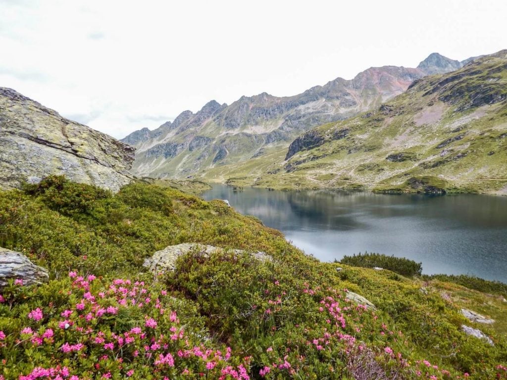
We’ve visited Schladming several times, always without a car. During our first trip, we trekked the spectacular and still-a-secret Schladminger Tauern High Trail. During our second visit, we stayed in Stadthotel Brunner and Thalers Mariandl and embarked on a series of day hikes to Lake Riesachsee, Preintalerhütte Mountain Hut, Lake Duisitzkarsee, Giglach Lakes, and Alpinsteig durch die Höll.
The Schladming-Dachstein region is one of our all-time favorite holiday destinations in Austria,, thanks to its wholehearted hospitality and irresistibly joyful atmosphere. It simply feels good to be here.
We also love the Almhütten (alpine pasture huts), Styrian food, and the many lakes that define the Schladminger Tauern range.
Additionally, the summer hiking buses make getting to/from trailheads really effortless. You absolutely don’t need a car.

- When to Hike: mid/late June – October
- Weather Forecast and Webcam: Bergfex Weather Schladming
- Swimming in mountain lakes: It’s technically allowed, but it’s not condoned. Only swim without sun lotion.
- Where to Stay in Schladming: Winzig Apartment (budget), TUI Blue Schladming (midrange), or Stadthotel Brunner (luxury)
- Where to Stay in Rohrmoos: Pension Stammerhof (budget), Hotel Garni Hochwurzen (midrange), or Thalers Mariandl (midrange)
- Recommended Trail Map: WK 201, Schladminger Tauern
- Recommended itinerary: 7-Day Austria Road Trip Itinerary
Schladming Hiking Map
1. Alpinsteig durch die Höll Trail


The Alpinsteig is a steep trail that connects the Parkplatz Seeleiten parking lot and the Almgasthaus Riesachfall restaurant to Lake Riesachsee in Untertall Valley.
Alpinsteig durch die Höll translates as “Alpine Trail through Hell.” The name doesn’t quite capture the essence of this hiking path. It’s not hellish at all! It’s verdant, lush, and alive.
The trail hugs the Riesachbach stream and ascends the thundering Höllschlucht gorge, giving you unobstructed waterfall and river views. All your senses are engaged as you hear the water plunge and stir down the gorge.
For safety reasons, the Alpinsteig trail can only be hiked one-way ascending to Lake Riesachsee. It’s a steep trail with many ladders and several bridges, including a 50-meter suspension bridge.
Just before the lake, you’ll see the Gfölleralm alpine pasture hut. Grab lunch here, before descending back to the Seeleiten parking lot.
The descent follows the Forest Road (“Forststrasse”).
You can easily extend this hike to Preintalerhütte. We’ll explain below.
Trailhead | Seeleiten Parking Lot / Riesachfall Bus Stop in Untertal: Google Maps
Bus Line | 974 Untertal – Wilde-Wasser
Toll | If you’re driving to the trailhead, you have to pay a toll.
Distance | 4.5 km circuit
Time Needed |2:30 hours
Elevation Gain/Loss | 295 meters
Difficulty | Moderate
2. Preintalerhütte Mountain Hut

This hike begins with the Alpinsteig durch die Höll ascent to Lake Riesachsee.
From the Gfölleralm alpine pasture hut, continue along the flat gravel path towards the lake. Continue following this path to the opposite end of Lake Riesachsee.
You’ll walk by several alpine pasture huts – Kaltenbachalm, Wieseralm, Schmiedlechneralm, Kerschbaumeralm, and Kotalm – before ascending to Preintalerhütte (1656 m).
After walking for about 40 minutes (from Gfölleralm) along the flat road, you’ll reach a signed intersection, steering you left onto a forest trail to Preintalerhütte (signed 45 minutes).
From the intersection, it’s 1.2 km (220 meters ascending) to Preintalerhütte.
Preintalerhütte is a great place for lunch and a refreshing beverage. They also have an espresso machine, which is a treat. Make sure to bring cash.
Directly next to the mountain hut, you’ll find another alpine pasture hut: Waldhornalm. During the pasture season, they sell homemade dairy products like Buttermilk.
Returning to Riesachsee
You can either head back to Riesachsee the way you came up (easier option), or you can follow trail 781 – which is Stage 5 of the Schladminger Tauern High Trail – to Neualm, before descending to the lake (the more difficult option).
The alpine trail to Neualm is difficult because it’s narrow, slippery (due to snowmelt), and partially exposed. Some exposed sections are secured with rungs and fixed cables.
It’s a thrilling hike with riveting views of the surrounding mountains and Riesachtal Valley, but it shouldn’t be underestimated. You need to be surefooted and have a head for heights.
It took us about 1:30 hours to hike from Preintalerhütte to Neualm (1849 m).
Neualm is “nicht bewirtschaftet,” meaning it’s not a managed alpine pasture (no food here). The alpine pasture is peppered with crumbling stone buildings and offers a bird’s-eye view of Lake Riesachsee.
From Neualm, continue left through the stone ruins and follow trail 777A down to Brand Alm (also “nicht bewirtschaftet”) and then ultimately down to Kerschbaumeralm, one of the alpine pasture huts along that gravel road (which you passed before).
The descent is quite pleasant, because the trail is soft (lots of pine needles and very few rocks).
Once you reach the Riesachtal valley floor, follow the familiar path back to Gfölleralm, and then take the Forest Road down to Parkplatz Seeleiten/Almgasthaus Riesachfall.
Trailhead | Seeleiten Parking Lot / Riesachfall Bus Stop in Untertal: Google Maps
Bus Line | 974 Untertal – Wilde-Wasser
Toll | If you’re driving to the trailhead, you have to pay a toll.
Distance | 12.6 km (Preintalerhütte), 14.1 km (Loop Trail via Neualm)
Time Needed | 4:20 hours (Preintalerhütte), 5:30 hours (Loop Trail via Neualm)
Elevation Gain/Loss | 644 meters (Preintalerhütte), 906 meters (Loop Trail via Neualm)
Difficulty | Moderate (Preintalerhütte), Difficult (Loop Trail via Neualm)
3. Wild Waters Theme Trail

The Wild Waters Theme Trail (Themenweg Wilde Wasser in German) technically begins in Schladming at the “Wanderportal Kraiter Talbachklamm” and then ascends all the way up the Untertal Valley to Riesachsee Lake via the Alpinsteig trail (described earlier).
A better way to do this hike is to take the Untertal hiking bus to Almgasthaus Riesachfall/Seeleiten-Parkplatz.
From here, you have the option to hike the Alpinsteig trail to Lake Riesachsee and back down via the forest road (2 – 2:30 hours circuit). After, continue along the Themenweg Wilde Wasser to Untertal village.
The Wild Waters theme trail descends slowly from Almgasthaus Riesachfall (Seeleiten-Parkplatz) all the way to Untertal-Dorf village and then ultimately down to Schladming.
This is a leisurely, family-friendly hike, perfect for days when you want to be outside and stretch your legs, but aren’t craving anything too strenuous.
The trail strings together several alpine pasture huts, which serve yummy regional cuisine. You won’t go hungry on this trail.
The trail is intuitive, but here are some directions:
Seeleiten Parking Lot to Sondlalm
From the parking lot, head back down the road for about 600 meters, until you see a bridge on your left.
Cross the bridge and continue walking along the Untertalbach stream.
You’ll follow the stream, until you see a left turn to the Sondlalm alpine pasture. You can grab lunch here, or continue to Waldhäuslalm.
Sondlalm to Waldhäuslalm
It’s a 20 minute walk (1.5 km) to Waldhäuslalm, an alpine pasture with a playground and a fish pond.
If you’re hiking with kids, you may want to have lunch here.
Everyone else, we recommend Sondlalm as it’s quiet and not directly on the main Untertalstrasse road.
Waldhäuslalm to Gasthof Tetter
From Waldhäuslalm, walk on the trail along Untertalstrasse road for 1.7 km to Gasthof Tetter.
Gasthof Tetter to Restaurant Landalm

Just before Gasthof Tetter, a trail descends down to the river (on your left). Follow this trail, cross the bridge and enjoy the views of the marshy Tettermoor.
On foggy days, it almost looks like a Norwegian Fjord.
After about 920 meters, the trail intersects with the road at a small parking lot.
Follow the road for about 3-4 minutes until you see the Janerbrücke bridge on your right. Cross this bridge and hike along Janerweg, which is a popular cycling path.
In some older guidebooks, it tells you to actually stay on the main road (left side of the river) for a few more minutes, until you come across a path by the river.
This path is now closed and no longer accessible to the public. So, make sure to cross at Janerbrücke bridge.
You’ll follow this Janerweg road to several isolated farmsteads, high above the Untertalbach stream. When conditions permit, the Dachstein range is visible straight ahead.
After walking along Janerweg for about 20 minutes (1.1 km), you’ll see a hiking trail on your left.
This narrow trail steadily descends across blooming flower fields towards Untertal-Dorf village and Landalm.
Restaurant Landalm to Schladming via the Talbachklamm

Landalm is an alpine restaurant with a quaint wooden interior, featuring traditional Austrian cuisine. We loved eating here. The food is excellent.
From Landalm, follow signs to Talbachklamm. You’ll hike along the fast-moving Talbach stream on a wide gravel pathway down to Schladming.
This final descent is a visual treat and a very nice ending to the Wilde Wasser Theme Trail.
Trailhead | Seeleiten Parking Lot / Riesachfall Bus Stop: Google Maps
Bus Line | 974 Untertal – Wilde-Wasser
Toll | If you’re driving to the trailhead, you have to pay a toll.
Distance | 11.6 km (without the Alpinsteig)
Time Needed | 4 hours
Elevation Gain | 44 meters
Elevation Loss | 369 meters
Difficulty | Easy
4. Duisitzkarsee – Neualm Circuit

Duisitzkarsee is a mountain lake, situated at an elevation of 1648 m. There are two ways to hike up to Duisitzkarsee from Eschachalm in Obertal: the hiking trail (“Wandersteig”) or the forest road.
It takes 1:15 hrs to hike the Wandersteig trail to Duisitzkarsee Lake. It’s a steep trail that weaves its way up the forest, sometimes intersecting with the forest road.
There are some water crossings (early summer), which can be slippery if you don’t have hiking poles. If you’re looking to buy trail poles, invest in these Unisex Black Diamond Hiking Poles (we’ve been hiking with them for years).
You’ll eventually join the forest road and walk the remaining 5 minutes to the lake.
At the lake, there are two huts, Duisitzkarseehütte and Fahrlechhütte, which serve food and drinks. Both are charming. We opted for Duisitzkarseehütte and ate way too much food. No regrests, though.
Before/after lunch, we recommend hiking around the lake for the best views. The circuit trail is flat and easy. However, early in the season, it’s marshy due to snowmelt.
From Duisitzkarsee, continue to the Neualm mountain pasture (nicht bewirtschaftet / not managed). The trail to Neualm starts at the bridge near the lakeshore.
Follow the upper track. The undulating trail to Neualm is enjoyable and takes about an hour (2.6 km). There are a few fixed rungs along the way, to aid hikers across some rocky passages.
You’ll cross the stream at Neualm and then follow the track along the Obertalbach stream back down to Eschachalm (trailhead/alpine pasture hut).
We stayed on the forest road because the hiking trail was closed due to an avalanche. The 410-meter descent takes about 1:00-1:15 hours.
Trailhead | Eschachalm in Obertal: Google Maps
Bus Line | 973 Obertal
Distance | 9.9 km
Time Needed | 4 hours (5 hours with lunch)
Elevation Gain/Loss | 592 meters
Minimum Elevation | 1197 meters
Maximum Elevation } 1743 meters
5. Ursprungalm to Giglach Lakes
Learn more about this trail in our guide to visiting Ursprungalm.
Trailhead | Ursprungalm: Google Maps
Bus Line | 972 Ursprungalm – Preuneggtal
Distance | 8.2. km lollipop-circuit
Time Needed | 4 hours
Elevation Gain/Loss | 415 meters
Difficulty | Easy
6. Schladminger Tauern High Trail

If you love pristine alpine lakes, the five day Schladminger Tauern High Trail is for you. On day 1, you’ll hike by Klammsee, Brettersee, and Giglachseen.
On day 3, you’ll hike to Oberen Landawirsee and Unteren Landawirsee. And on day 4, you’ll cross the Klafferkessel cirque, which contains more than 30 lakes.
When we think about which treks in Austria we want to re-do, this is always our #1 choice. It’s not crowded.
The huts are small and intimate. And, of course, the food is excellent. We’re hoping that the hut management along this route never changes.
Starting Point/Ending Point | Schladming
Duration | 5 Days
Distance | 45 km circuit
Difficulty | Difficult
When to Hike | July, August, September
Learn More: Schladminger Tauern High Trail Trekking Guide
Where to Stay in Schladming or Rohrmoos in Summer


We recommend staying at least 3-4 nights in Schladming or Rohrmoos to get a taste for the region.
If you want easy access to shops, bars, multiple restaurants and cafés, we recommend staying in Schladming.
If you want more solitude, unbeatable views of the Dachstein mountains, and quicker access to the Untertal/Obertal/Preuneggtal valleys, stay in Rohrmoos village (just above Schladming).
It’s only a 6 minute drive, or 12 minute bus ride between Schladming and Rohrmoos, but there’s a notable difference between the two.
If you’re sensitive to noise and want more countryside vibes, stay in Rohrmoos. If you’re traveling without a car and you want to be where the action is, stay in Schladming.
Our Favorite Hotel in Rohrmoos

Thalers Mariandl
Thalers Mariandl is a family-run bed & breakfast in Rohrmoos. Aesthetically pleasing and thoughtfully designed, Thalers Mariandl feels instantly fresh and young. A new generation is eagerly embracing the concepts of mindfulness (yoga), sustainability (plastic-free), and well-being (wellness area, terrace, bedroom design).
Beyond the eye-catching larch paneling and the pastel accents, it’s the wholehearted hospitality that makes Thalers Mariandl so special. The family and staff are kind, casual, and always available to help you. The atmosphere is laid-back (no stiffness here).
More reasons to stay here:
- Great views of the Dachstein and the Schladminger Tauern mountains.
- Delicious, well-balanced breakfast.
- Bar & limited snack menu available in the evening. Tip: order the Brettljause (snack board) in advance.
- Bio sauna, Finnish Sauna, relaxation area, and tea bar.
- 2-minute walk to the Rohrmoos-Zentrum bus stop.
- Free parking.
- Complimentary Schladming-Dachstein Summer Card.
Our Favorite Hotel in Schladming
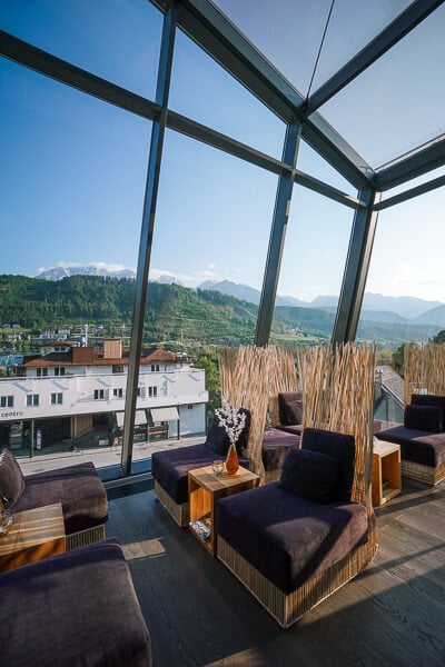
Stadthotel Brunner
With its sparkling, modern facade and swoon-worthy lobby, Stadthotel Brunner isn’t your average alpine accommodation. Here, ayurvedic cuisine, digital art, and bold design choices create a distinctly modern atmosphere.
Stadthotel Brunner is also a very popular restaurant and bar, serving Austrian favorites as well as ayurvedic dishes. The food is excellent. Definitely make a dinner reservation for at least one of the nights you’re staying here.
Located directly in the heart of Schladming, everything is easily accessible by foot: bars, restaurants, gelaterias, and shops of all kinds. You can walk to the Talbachklamm as well as the Planai cableway valley station (also a bus stop) in 5 minutes. Even the Schladming Train Station is only 1.1 km away (a 15 minute walk).
More things we loved:
- The soothing lighting. You’ll notice this especially in the hallways and in the bedrooms.
- The wellness area occupies the top floor, and encompasses a Finnish sauna, hanging egg chairs, a sun terrace (with views of the town and Dachstein), a relaxation room, and a spacious shower.
- The panoramic tea room.
- The colorful breakfast features unique flavors and ingredients.
- Complimentary Schladming-Dachstein Summer Card.
Schladming Hiking Buses
When you stay in a “Sommercard partner” accommodation like Thalers Mariandl or Stadthotel Brunner in the Schladming – Dachstein region, you receive a complimentary Schladming-Dachstein Sommercard (Summer Card).
This card gives you free rides on all regional hiking busses and cableways.
Here’s the current Bus Timetable (“Fahrplan” in German).
Below, we’ve summarized the hiking buses that you should take advantage of during your stay in Schladming, or Rohrmoos.
We recommend taking the bus, to avoid paying tolls and for laid-back exploring.
Bus Schedule
Buses during summer season run generally between mid-May and early/mid October.
Hiking Bus 972: Preuneggtal Valley to Ursprungalm
This bus connects Schladming and Rohrmoos with the picturesque Ursprungalm alpine pasture.
From Ursprungalm, you can hike to the gorgeous Giglach Lakes or summit the Styrian Kalkspitze (2459 m).
We recommend taking the bus, because the mountain road is narrow and challenging to drive.
Furthermore, it’s expensive. Current toll road prices.
Hiking Bus 974: Untertal Valley to Riesachfall
This bus connects Schladming and Rohrmoos with Untertal-Dorf (Untertal valley village) and the Riesachfall Waterfall/Seeleiten Parking Lot.
From Riesachfall, you can hike up the Alpinsteig durch die Höll trail through a steep gorge to Riesachsee Lake (1 hour). You can also continue to Preintalerhütte mountain hut (2:30 hours).
For a more leisurely walk, we recommend descending Untertal Valley along the Wild Waters Theme Trail (Themenweg Wilde Wasser in German) all the way down to Schladming (4 hours).
Hiking Bus 976: Seewigtal Valley to Steirischer Bodensee
This bus connects Schladming with the Steirischer Bodensee Lake. From the bus stop, you can walk to the lake in 5 minutes. There’s an easy trail that circuits the lake.
You can also continue hiking to Hans-Wödl mountain hut (1533 m) and Hüttensee and Obersee Lakes.
If you’re staying in Rohrmoos, you have to take bus 971 to Schladming first.
Hiking Bus 973: Obertal Valley to Eschachalm
This bus connects Schladming and Rohrmoos with Eschachalm and Hopfriesen in the Obertal Valley. We used this bus to hike to Lake Duisitzkarsee.
More Austria Hiking Guides
Hikes in the Dachstein:
- Hofpürglhütte – Sulzenalm Trail, Filzmoos
- Rötelstein Peak Hike, Filzmoos
- Bachlalm to Neustadtalm Circuit Hike, Ramsau/Filzmoos
- 5 Huts Trail, Ramsau am Dachstein
- Filzmoos Hiking Guide
Day Hikes:
- Best Day Hikes in Austria
- Austrian Alps Hiking Destinations
- Best Hikes in Salzburg
- Best Hikes in Tyrol
Treks:
Seasonal Guides:

Pin this Image for Future Trip Planning!
Stay Connected:
Connect with us on Pinterest.
Follow us on Instagram.
Like us on Facebook.
Support Us:
If you love reading my content, you can send me a direct donation.


Hi. My wife and I are planning to spend a two nights in Schladming the first week of September and hike to Giglachsee Lakes. We will not be staying a hotel that offers the sommercard. How much does the card cost? Or can one just pay for a bus ticket when boarding the hiking bus 972? Do you know how much that would cost? We will have a rental car, so could do the drive. This will be our first trip to Austria and trying to figure out everything. Many thanks!
Hi Joel,
You can drive to Ursprungalm (18 EUR toll), the trailhead. You can also pay for the bus ride. Please contact the Schladming-Dachstein tourist office for up-to-date pricing.
All the best,
Sabrina
–> Mountain pasture safety rules & tips: While hiking in this region, you’ll encounter many mountain pastures with free-roaming cattle. Please familiarize yourself with these rules before your trip.
Just a quick note to say that the link to those rules was broken, but a quick google found them. I have a dog so I was curious to see the rules, but it’s really just common sense to me. (I lived in the UK with our dog for 9 years so my wife and I encountered a LOT of sheep and cattle there on hikes.) Anyway, the new link is here:
https://www.schladming-dachstein.at/en/regional-and-offerings/blog_/rules_meadows
Thank you for such a fabulous site! I just discovered it a couple of days ago and I believe I will use it a lot now that we have moved to Vienna. You two are my types of travelers!
Thank you Ed! Updated! Schladming-Dachstein is a great area. Have fun!