Salzburg State, or SalzburgerLand, is a mecca for hikers in Austria, offering a variety of trails that snake through dramatic gorges, trace rugged ridges, traverse alpine meadows, and cross sweeping karst plateaus.
What makes Salzburg such a special hiking destination in Austria is its alpine pasture culture: the rustic huts (Almhütten), grazing cattle, and the aroma of homemade Kaspressknödel that greet you along the trails. Alpine huts exist across Europe, but there’s something about those in Salzburg that feels especially warm and welcoming, always inviting you to relax, gather and enjoy a hot meal and a cold drink.
Kati and I live in Austria and have spent the past 10 years hiking across many of Salzburg’s mountain ranges, including the Northern Limestone Alps subranges such as the Hochkönig, Tennengebirge, and Dachstein, as well as the Hohe Tauern, Radstädter Tauern, and Niedere Tauern.
Here are my favorite Salzburg hikes.

- When to Hike in Salzburg: June – October, depending on snow conditions.
- Getting around Salzburg: Check regional bus and train schedules on Salzburg Verkehr. However, not all trailheads are accessible by bus. The most stress-free way to get around is with a car. Use the Discovercars.com car rental reservation platform to book car rentals.
- Payment culture: Always bring EUR cash when hiking and traveling in Austria. You’ll need cash for toll roads, parking machines, and huts (food & drinks).
- Mountain Huts: Mountain huts (Hütte, Hütten) accommodate overnight guests throughout the hiking season (June-September). Opening times are dependent on the hut’s elevation and snow conditions. There are a soaring 1,800 alpine huts in Salzburg, 550 of which are open in summer.
- Alpine Pastures: Many hiking trails traverse alpine pastures, where cattle graze during the summer months. Respect the animals and do not disturb, touch, or provoke them. Learn more: Visiting the Alps in summer.
Salzburg Hiking Map
Trails
Riemannhaus
Taghaube
Mühlbach High Trail
Hochkeil
Werfener Hütte
Gosaukamm Circuit
Hofpürglhütte – Sulzenalm
Rötelstein Peak
Bachlalm
Liechtenstein Gorge
Lake Tappenkarsee
1. Hofpürgl Hut to Sulzenalm Circuit Trail

This grand circuit hike in Salzburg follows the base of the Bischofsmütze and Gosaustein in the Dachstein Mountains. I’ve hiked this trail twice, and on both occasions, I was blown away by the scenery.
Start at Hofalm, at the end of the Hofalm toll road north of Filzmoos. From here, a steady ascent leads to Hofpürglhütte (1,705 m), perched on a ridge beneath the Bischofsmütze twin peaks. Above the tree line, the views of limestone rock walls unfold spectacularly.
From Hofpürglhütte, follow the Linzer Steig east across the boulder-strewn slopes, gullies, and scree fields to Rinderfeld, a wide alpine pasture flanked by towering limestone walls. The trail continues up to Sulzenschneid ridge and Eiskarlschneid, the highest point of the hike marked by a summit cross.
The descent leads to the Sulzenhals saddle and then through dwarf pine and larch forest into the open pastures of Sulzenalm, home to Wallehenhütte and Krahlehenhütte. These charming huts serve hearty meals throughout the day. From Sulzenalm, it’s a relaxed 45-minute descent back to Hofalm.
Trailhead | Hofalm, Filzmoos
Distance | 12.9 km circuit
Time Needed | 5:15 hours
Elevation Gain/Loss | 912 meters
Difficulty | Moderate – Moderately Difficult
Where to Stay in Filzmoos | Bauernhof Krahlehenhof (midrange), Das Anja Alt Filzmoos (midrange), meiZeit Lodge (luxury)
Learn More: Hofpürgl Hut to Sulzenalm Circuit Hike
2. Rötelstein Ridge Hike

Rötelstein (2,247 m), also known as Rettenstein, rises northeast of Filzmoos just south of the Dachstein massif. The summit commands the most striking view of the Gosaukamm and the south face of the Dachstein.
If you love ridge hikes as much as I do, you will love this trail. However, hiking to the summit is no easy feat; it’s a demanding route with exposed sections and sustained scrambling at times.
From the Rettensteinhütte (open in winter only), the trail climbs steadily through forest and alpine pasture to the southwest flank of Rötelstein. It then follows the main ridge to the summit, alternating between hiking and scrambling.
The final approach is especially impressive, with close-up views of Torstein (2,948 m), Mitterspitz (2,925 m), and Hoher Dachstein (2,995 m).
From the summit, the route continues north across the ridge before dropping steeply down the northeast side. The descent is steep and rocky, with waymarked passages leading through scree and scrambling sections to the Sulzenhals saddle.
From here, it’s an easy walk to Sulzenalm, where Wallehenhütte and Krahlehenhütte serve excellent food, including Kaiserschmarrn. From the junction opposite Krahlehenhütte, turn left and loop around the Mandlinghofalm, with the Bischofsmütze peaks rising above. The trail then leads through forest and meadows back toward Rettensteinhütte, finishing along a forest road and short paved stretch to the start.
Trailhead | Rettensteinhütte car park
Distance | 9.8 km circuit
Time Needed | 5 hours
Elevation Gain/Loss | 937 meters
Difficulty | Difficult
Where to Stay in Filzmoos | Bauernhof Krahlehenhof (midrange), Das Anja Alt Filzmoos (midrange), meiZeit Lodge (luxury)
Learn More: Rötelstein Peak Hike
3. Gosaukamm Circuit Trail

Gosaukamm, the westernmost subgroup of the Dachstein range, is a striking limestone formation spanning Salzburg and Upper Austria. A 21.6 km hiking circuit encircles the Gosaukamm group, offering a challenging trek that can be completed in one or two days.
Hikers beginning in Filzmoos in Salzburg typically spend the night at Gablonzer Hütte. Those starting from Lake Gosau in Upper Austria’s Salzkammergut region have two options: an overnight stay at Hofpürglhütte or a demanding single-day hike. The latter is only recommended for experienced and highly fit mountain hikers, beginning at the Gosaukammbahn mountain station.
Kati and I started at Lake Gosau.
Trailhead | Oberhofalm in Filzmoos, or Gosaukammbahn mountain station
Distance | 18.7 km
Time Needed | 7:15 hours without breaks. We needed 9 hours.
Elevation Gain | 923 meters
Elevation Loss| 1469 meters
Difficulty | Difficult
Where to Stay in Filzmoos | Bauernhof Krahlehenhof (midrange), Das Anja Alt Filzmoos (midrange), meiZeit Lodge (luxury)
Learn More: Gosaukamm Circuit Trail
4. Seisenberg Gorge Hike
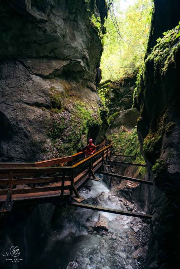
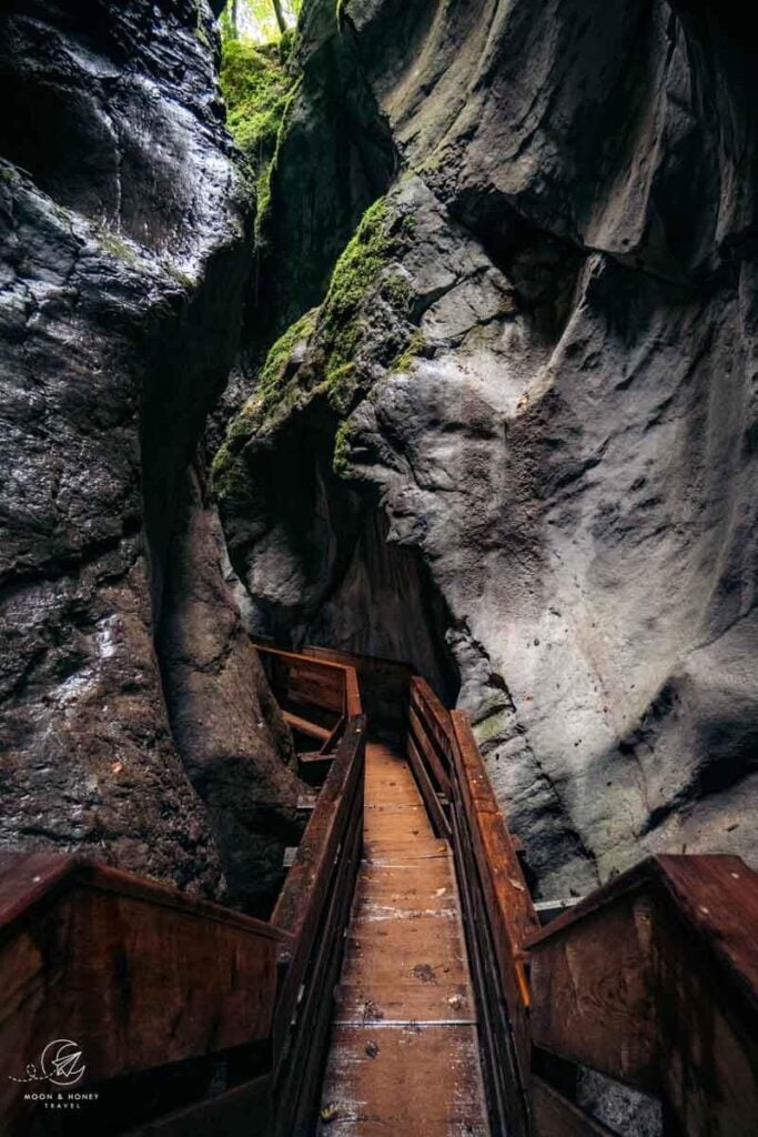
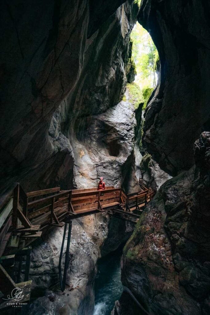
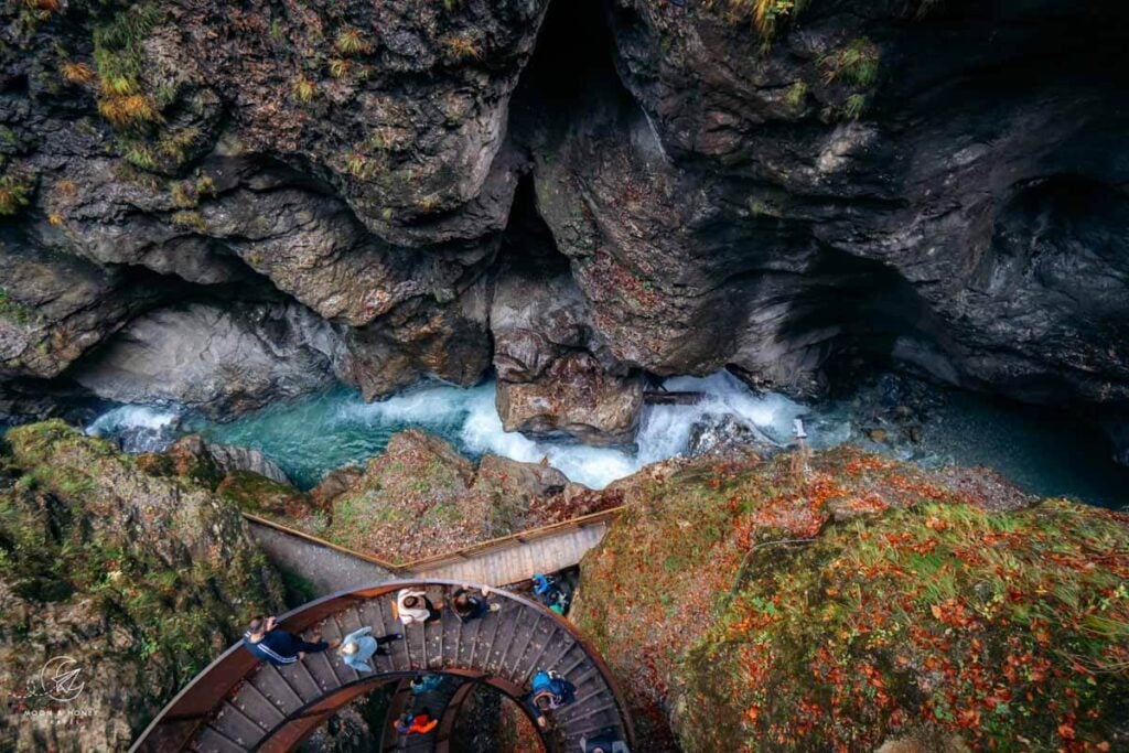
Ever since hiking through Partnach Gorge and Höllental Gorge in Bavaria, I’ve been obsessed with narrow river gorges. I’ve dragged Kati along to Liechtensteinklamm, Wolfsklamm, and Sigmund Thun Klamm. But in Salzburg, none compare to the bewitching Seisenbergklamm in Weißbach Nature Park in the Saalachtal Valley.
The 600-meter-long Seisenberg Gorge, formed around 12,000 years ago, is a declared natural monument near Weißbach bei Lofer. While it’s long been a tourist attraction, the gorge once served a practical purpose as a log-driving route used to transport timber in the 19th century.
To visit, head to Weißbach bei Lofer, north of Saalfelden, between May and October. After paying the entrance fee, follow a gravel path along the Weißbach stream until the boardwalk and footbridge trail begins. In places, the gorge narrows dramatically, with sheer rock walls closing in on either side. The most dramatic section winds up and down staircases through the shadowy chasm called Dunkelklamm (“dark gorge”).
We visited in October, and with fewer crowds, we were able to walk back through the gorge the same way to the entrance.
Trailhead | Klammstüberl, Weißbach bei Lofer
Distance | 4.4 km out-and-back
Time Needed | 1:30 hours
Difficulty | Easy
5. Riemannhaus and Breithorn Peak

Riemannhaus (2,177 m) is a mountain refuge dating back to 1885, sitting between Sommerstein and Breithorn on the Steinernes Meer (“Stone Sea”) karst plateau.
The Steinernes Meer is part of the Berchtesgaden Alps, a Bavarian-Salzburg border range, which is home to the famous Lake Königssee and Berchtesgaden National Park.
The Riemannhaus hike starts at the Sandten car park (access by car only), just north of Maria Alm in the Hochkönig region. From the car park, follow the gravel road north to the hut’s material lift station. We recommend staying on the road, as hiking trail 401a is currently affected by landslides and avalanches.
Shortly before the lift, a narrow trail branches off and climbs steadily through rocky terrain to the hut in about 1:45 hours. Some sections are secured with fixed cables.
From Riemannhaus, you can extend the hike across the karst plateau to Breithorn (2,504 m), about 1 hour one-way. This section involves scrambling and requires surefootedness. Follow trail 428 to the summit. Return to Sandten car park via the same route.
Trailhead | Sandten car park, Maria Alm am Steinernen Meer
Distance | 10.3 km out-and-back
Time Needed | 6:30 hours
Elevation Gain/Loss | 1370 meters
Difficulty | Moderately Difficult
Where to Stay in Maria Alm | Apartments-Pension Renberg (midrange), or Hotel Eder (luxury)
6. Lake Tappenkarsee Hike

Tappenkarsee is a mountain lake in the Radstädter Tauern range, framed by rugged peaks and home to two welcoming alpine huts: the rustic Tappenkarsee Alm and the Tappenkarseehütte. Both are typically open from early June to mid or late September.
The hike starts at Jägersee in the Kleinarl Valley, about 4 km south of Kleinarl and 11.6 km from Wagrain. You can reach it by car or bus. If the toll road is open, continue 3.6 km further to the Schwabalm car park. Otherwise, park at Jägersee. From here, the trail climbs through forested switchbacks to Tappenkarsee. Follow the shoreline past Tappenkarsee Alm to Tappenkarseehütte.
For a longer route, continue up to the Draugsteintörl saddle, where alpine meadows open up and views of the lake keep shifting with every step. From the saddle, descend back to Tappenkarsee Alm and return the same way.
Trailhead | Jägersee Car Park / Jägersee Bus Stop
Distance | 19.9 km lollipop-circuit
Time Needed | 7 hours
Elevation Gain/Loss | 985 meters
Difficulty | Moderate
Where to Stay in Kleinarl | Privatzimmer/Apartments Schwarzenbacher (budget) or Hotel Ennskraxblick (midrange)
Where to Stay in Wagrain | Wanderhotel Erika (midrange) or The MATTHEW – Copper Lodge (luxury)
Learn More: Tappenkarsee Trail Guide
7. Bachlalm and Neustattalm Circuit Trail

This blissfully easy circuit trail winds through forest and across meadows at the foot of the Dachstein Südwand, in the border region between Salzburg and Styria.
The hike starts at the Bachlalm car park on the Filzmooser Straße, between Filzmoos (Salzburg) and Ramsau am Dachstein (Styria). Follow the private Bachlalm road up toward Schaidlalm. From there, take a short detour to Bachlalm before continuing through forested sections and wide, open meadows to Neustadtalm.
The circuit then leads on to Glösalm restaurant before descending via the Dureggrundweg trail through Dachsteinruhe and back to the Bachlalm car park.
Trailhead | Bachlalm Car Park, between Filzmoos and Ramsau am Dachstein
Distance | 10.4 km circuit
Time Needed | 3:45 hours
Elevation Gain/Loss | 588 meters
Difficulty | Easy
Where to Stay in Filzmoos | Bauernhof Krahlehenhof (midrange), Das Anja Alt Filzmoos (midrange), meiZeit Lodge (luxury)
Learn More: Bachlalm to Neustadtalm Circuit Hike
8. Mühlbach High Trail: Arthurhaus to Erichhütte

The Mühlbach High Trail (Mühlbacher Höhenweg) runs along the foot of the Hochkönig massif between Arthurhaus and Erichhütte, crossing meadows and patches of forest along the way. It also forms stage 2 of the Salzburg Almenweg long-distance trail.
You can start the hike from either Arthurhaus (paid car park and bus stop) above Mühlbach am Hochkönig or from the Erichhütte car park (free) along the Hochkönigstraße in Dienten am Hochkönig.
We parked at the Erichhütte car park, took bus 593 to Arthurhaus, and hiked back. The bus ride takes about 40 minutes and can be paid directly to the driver by cash or card. For a longer day, I recommend adding the Hochkeil summit from Arthurhaus or the Taghaube peak from Erichhütte.
Starting Point | Arthurhaus, Mühlbach am Hochkönig
Ending Point | Erichhütte Car Park, Dienten am Hochkönig
Distance | 11.2 km point-to-point
Time Needed | 3:30 hours
Elevation Gain | 226 meters
Elevation Loss | 377 meters
Difficulty | Easy
Where to Stay in Mühlbach am Hochkönig | Landhaus Rieding (midrange) Das Grünholz Aparthotel & Restaurant (luxury), Hotel Bergheimat (luxury)
Where to Stay in Dienten am Hochkönig | The Peak Hochkönig (luxury)
Where to Stay in Maria Alm | Apartments-Pension Renberg (midrange), or Hotel Eder (luxury)
Learn More: Mühlbach High Trail
9. Taghaube Peak

Taghaube (2,159 m) is a peak in the Hochkönig Mountains. The hike to the summit is especially rewarding, because the route stays above the tree line. As with many great Salzburg hikes, there’s also a managed alpine hut and pasture along the way.
Start at the Erichhütte car park, between Dienten am Hochkönig and Mühlbach am Hochkönig. From there, follow the access road to Erichhütte (about 20 minutes), then cross the open meadow to the base of Taghaube (another 20 minutes). Continue on trail 437 through dwarf pine and into steeper rocky terrain to reach the summit in about 1:20 hours. Return to the car park via the same route.
Trailhead | Erichhütte car park, Dienten am Hochkönig
Distance | 6.4 km out-and-back
Time Needed | 3 hours
Elevation Gain/Loss | 810 meters
Difficulty | Moderately Difficult
Where to Stay in Dienten am Hochkönig | The Peak Hochkönig (luxury)
Where to Stay in Maria Alm | Apartments-Pension Renberg (midrange), Hotel Eder (luxury), or Jufenalm BOHO Hotel & Restaurant (luxury)
Learn More: Taghaube Trail Guide
10. Wengerau to Werfener Hütte

Werfener Hütte is a mountain hut in the Tennengebirge (Tennen Mountains), perched high above the Salzach Valley. Starting in Wengerau, the trail first passes Wengerau Alm, then reaches Gamsblickalm (1,019 m) about 15 minutes later. From there, it continues 2.3 km to Elmaualm, and a further 1.7 km to Werfener Hütte.
Trailhead | Wengerau Car Park, Werfenweng
Distance | 10.6 km out-and-back
Time Needed | 4:30 hours
Difficulty | Moderate
Elevation Gain/Loss | 994 meters
Where to Stay in Werfenweng | Zistelberghof (budget), or Travel Charme Bergresort Werfenweng (midrange)
11. Hochkeil Summit and Troiboden Lake

Hochkeil (1782 m) is a panoramic mountain, which stands south of the striking Mandlwand, which forms the southeast flank of the Hochkönig massif.
Starting at Arthurhaus, high above Mühlbach am Hochkönig, a wide gravel road leads to the summit in one hour. Along the way, I recommend detouring to the mountain lake at Troiboden (Bergsee am Troiboden, or Spiegelsee am Hochkeil in German). This tiny body of water serves as a reflection pool for the saw-toothed Hochkönig peaks.
Trailhead | Arthurhaus, Mühlbach am Hochkönig
Distance | 6.1 km out-and-back
Time Needed | 2 hours
Elevation Gain/Loss | 284 meters
Difficulty | Easy
Where to Stay in Mühlbach am Hochkönig | Landhaus Rieding (midrange) Das Grünholz Aparthotel & Restaurant (luxury), Hotel Bergheimat (luxury)
Where to Stay in Dienten am Hochkönig | The Peak Hochkönig (luxury)
Learn More: Hochkeil Hike
12. Liechtenstein Gorge
Liechtensteinklamm is a deep and narrow gorge in Salzburg, located a few kilometers south of St. Johann im Pongau.
A safe, family-friendly trail leads through the misty gorge, running through illuminated tunnels and galleries, over bridges, and along secured walkways.
The gorge is open between May and October.
Trailhead | Liechtensteinklamm Car Park, St. Johann im Pongau
Distance | 2.5 km out-and-back
Time Needed | 1 – 1:30 hours
Elevation Gain/Loss | 100 meters
Difficulty | Easy
Where to Stay in St. Johann im Pongau | Landhotel Lerch Plankenau (midrange), Apartments Maurachhof (midrange), Alpina Family, Spa & Sporthotel (luxury), Hotel Oberforsthof (luxury)
Learn More: How to Visit the Liechtenstein Gorge
13. Salzburger Almenweg

Marked by the blue Enzian alpine flower, the Salzburger Almenweg is a 31-stage long-distance hiking trail in Salzburg. As the name suggests, this is a thematic hiking trail linking the region’s Almen, or high alpine pastures. The entire circuit is 350 km and connects 120 Almhütten (alpine pasture huts).
The Salzburger Almenweg traverses the holiday regions of Gastein, Grossarltal, Hochkönig, Filzmoos (Dachstein), Tennengebirge, “Salzburger Sonnenterrasse,” and Pongau.
This long distance trail is suitable for active families with children. From our experience, the trails are easy to moderate, very well-maintained, and easy to follow.
We hiked several segments of the Salzburger Almenweg as day hikes. Our favorite stage of the Salzburger Almenweg is Stage 2 between Erichhütte and Arthurhaus in the Hochkönig Mountains.
Where to Stay in Salzburg for Hiking

We’ve stayed in Filzmoos, Mühlbach am Hochkönig, Maria Alm am Steinernen Meer, and Saint Johann im Pongau.
I’m partial to Filzmoos, a down-to-earth alpine village set below the Gosaukamm, just a 1-hour drive from Salzburg City. Filzmoos is an ideal base for hiking in the Dachstein mountains and even the Schladminger Tauern range in neighboring Styria. The best accommodations are Bauernhof Krahlehenhof (farm stay with breakfast), Das Anja Alt Filzmoos (3-star aparthotel), meiZeit Lodge (4-star hotel with breakfast), and Hotel Neubergerhof (4-star hotel with half board).

I also like the Hochkönig holiday region, which encompasses the towns of Mühlbach am Hochkönig, Dienten am Hochkönig, and Maria Alm am Steinernen Meer. Maria Alm, settled since the 6th century AD, is the most beautiful of the Hochkönig villages. We stayed in Eder – Lifestyle Hotel in the village center (more info in my Hotel Eder Review), which serves as a local gathering point and is therefore more atmospheric than most accommodations in the area.
Mühlbach offers a range of accommodations, the most interesting of which are located on the mountainside. Landhaus Rieding is a guesthouse on the Riedingalm mountain pasture. The family-run Das Grünholz Aparthotel & Restaurant and 4-star Hotel Bergheimat (with half board) is located aloong the Mandlwandstrasse, about halfway between the town center of Mühlbach and Arthurhaus.
Austria Hiking Guides
Austria Hiking Guides:
Tyrol Hiking:
Trekking:
Hiking-Themed Austria Itineraries:
- 2-Week Austria Road Trip
- 1-Week Austria Road Trip
- 10-Day Bavarian Alps – Tyrolean Alps Road Trip
- Salzkammergut Itinerary


Pin this Image for Future Trip Planning!
Stay Connected:
Connect with us on Pinterest.
Follow us on Instagram.
Like us on Facebook.
Support Us:
If you love reading our content, you can buy us a coffee via Ko-Fi.


Hi there! My husband and I are planning a trip to Austria in the first part of May. All of these hikes look wonderful but you suggest doing them later in the season. Could you direct me to some hikes that would be safe to do in May? Do you suggest waiting until June for these hikes because of snow?
Thank you in advance!
Hi Maren,
I do recommend waiting until June. It’s difficult to say what’s possible in May, as it depends on how long the winter is.
– Sabrina
Hi- if I were to hire a car and hike stage 2, how would I get from Arthurhaus back to Erichhütte Parkplatz?
Hi Paul,
I think you take bus 593. Use this website to find the best connection:
https://fahrplan.salzburg-verkehr.at/
-Sabrina
Hi, do they close all this hike in May? What would happen if I want to hike on one of these routes this year in early May (2022). Thank you very much!
Hi, trails aren’t “closed” per se, but access depends on the amount of snow. This year, it might be feasible to hike in May, because there isn’t a lot of snow this winter season.