The circuit hike to Seekopf (summit) and Hirschwand (rock wall) is a fun excursion in the Wachau Valley in Austria. It ties together several outstanding viewpoints overlooking the Danube River. Though there are sweeping views along the way, this is largely a forest hike.
This hike begins in Oberkienstock village on the Danube and steadily ascends the Meurersteig trail to Seekopf hill (671 meters), crowned with a large lookout tower. From Seekopf, the hike continues northeast in the direction of St. Lorenz. Along the way, there’s an optional detour to Hirschwand (easy and short secured scramble).
A few more viewpoints await you as you descend to the riverside village of St. Lorenz. To complete the circuit, follow the bike path along the river back to Oberkienstock.

- Trailhead: Parkplatz Seekopf, Oberkienstock | Google Maps
- Distance: 9 km circuit
- Time Needed: 3:30 hours
- Elevation Gain/Loss: 544 meters
- Difficulty: Moderate
- Minimum Elevation: 200 meters
- Maximum Elevation: 671 meters
- When to Hike: April – November
- Weather Forecast and Webcam: Bergfex Weather Weissenkirchen
- Where to Stay in Weissenkirchen: Hotel Garni Weinquadrat (midrange) or Hotel-Restaurant Kirchenwirt (midrange-luxury)
- Recommended Trail Map: WK 0071 Wachau 1:50 000 (Freytag + Berndt)
- Recommended Itinerary: Austria Road Trip Itinerary (2 weeks
Seekopf and Hirschwand Hiking Map
Seekopf Trail Description
Oberkienstock to Seekopf (1 hour)

From the Seekopf car park in Oberkienstock, follow the sign to Seekopf (1:20 hours).
At first, the Meurersteig traces the graben floor.
After only a few minutes, red arrows and red-white-red painted waymarks steer you right to the flank of the graben.
The trail ascends a healthy forest of beech trees with thick gray, elephant-like trunks.
Follow the serpentines up the Dunkelsteinerwald (Dark Stone Forest). As you progress, parts of the forest floor are strewn with black boulders and rocks.
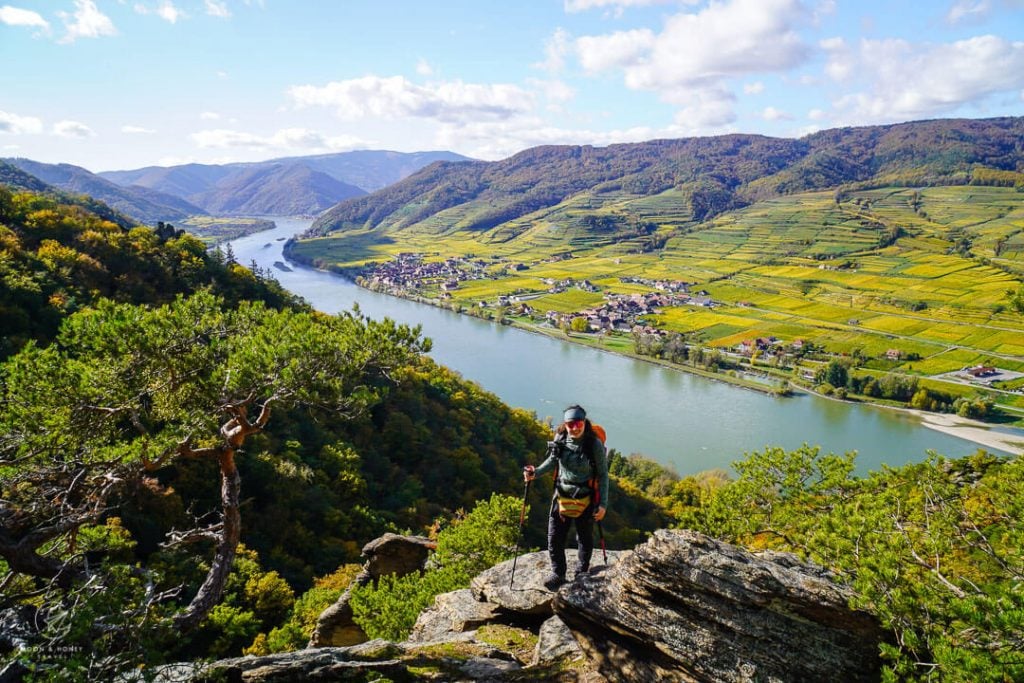
After about 50 minutes, you’ll arrive at the first viewpoint overlooking the Danube River and Wösendorf in der Donau encircled by vineyards.
The forest ascent continues another 10 minutes to Seekopf (671 m) and the base of the Seekopf Lookout Tower.
Walk up the stairs to reach for sweeping views of the Danube River Valley.
Seekopf to Kreuzung Hirschwand (15 minutes)

Return to the base of the tower.
From this point on, follow the white-painted Welterbesteig Wachau waymarks and the white-blue-white waymarks in the direction of Fähre St. Lorenz-Weissenkirchen (2 hours) mit Hirschwand.
For 2-3 minutes, the trail to Hirschwand follows a wide forest trail. At the bend, leave the wide trail and continue straight onto the obscure overgrown trail.
Follow the waymarks through the forest, mostly descending. You’ll pass through a rocky area to reach the Kreuzung Hirschwand (575 m) trail junction.
Hirschwand Kreuzung Lollipop-Circuit (20 minutes)

This is an optional detour to the panoramic summit of Hirschwand, a narrow rock wall. The immediate ascent and descent follows a short, secured climbing route (Klettersetig grade A/B).
Bear right to Hirschwand, signed 10 minutes.
After about 120 meters, you’ll see a “Hirschwandsteig” plaque on the left and the base of the southwest secured route (Grade A).
Ignore the plaque/cables and continue following the narrow trail to the base of the southeast secured route (Grade A/B). There’s another plaque here.
It’s easier to tackle the circuit counter-clockwise.
Use the fixed cables and rungs to safely scramble up to the top of Hirschwand. The summit is marked with a Lower Austrian flag and summit register. The circuit continues across the summit and down the easier southwest flank.
Return to the Hirschwand Kreuzung junction.
Kreuzung Hirschwand to Kreuzung St. Lorenz (1:30 hours)

Follow the sign to Fähre St. Lorenz-Weissenkirchen (1:45 hours).
On paper trail maps, this trail is labeled “Steinige Riess-Steig.”
The undulating way to St. Lorenz slowly traverses a mixed forest (oak, beech, birch trees), passing some bizarre rock towers and walls.
Every now and again, views open up to the Danube.
Continue following the white Welterbesteig Wachau waymarks, ignoring promising shortcuts.
A easy wide path brings you to the Kreuzung St. Lorenz intersection.
Kreuzung St. Lorenz to Memorial at the Friedenskreuz St. Lorenz (5 minutes)

At the Kreuzung St. Lorenz (229 m) trail junction, follow the signs to Rollfähre St. Lorenz-Weissenkirchen (15 minutes) and Panoramaweg/St. Lorenz, leaving the wide path.
The narrow trail leads to the Memorial at the Friedenskreuz St. Lorenz (Peace Cross St. Lorenz).
The first thing you’ll see is an alarmingly large art installation of “Deutsche Eicheln 1933” depicting Adolf Hitler watering a German Oak Tree with larger-than-life “Nazi” Acorns.
Let’s unravel this, shall we?
In 1933, the National Socialists took power in Germany. In response, John Heartfield designed the anti-fascist collage, “Deutsche Eicheln” (German Acorns) for the back cover of the Berlin magazine Arbeiter Illustrierte Zeitung (AIZ, 1933, Vol. 12, No. 37) as a way of warning against the rearmament of the Wehrmacht by the Nazis.
During the Second World War, the Jockisch Combat Group (named after commander Bernhard Jockisch), was deployed in former Yugoslavia. This unit of the Wehrmacht was engaged in daily battles with the Partisans and were responsible for a number of atrocities against the civilian population. They raised entire villages to the ground and murdered hostages.
In the 1960s, the Peace Cross St. Lorenz memorial was created for the fallen and missing soldiers of the Jockisch Combat Unit in the St. Lorenz area. The memorial consists of a 4-meter high cross, a commemorative plaque, Wehrmacht helmet, and laurel wreath.
The plaque states, “Zum Gedenken an die gefallenen Helden der Kampfgruppe Jokisch,” which means “In memory of the fallen heroes of the Jokisch combat group.” So, basically this memorial commemorates and applauds the actions of a brutal Nazi combat force.
In 2016, artist Martin Krenn installed Hartfield’s “Deutsche Eicheln” in front of the Peace Cross St. Lorenz. By mounting this art-piece in front of the memorial, Martin Krenn is demanding critical engagement with Austria’s Nazi past. And like John Heartfield, he’s also warning onlookers about the glorification of war and fascism.
After taking in the installation, turn towards the Danube and enjoy the fantastic view of Weissenkirchen village.
Memorial at the Friedenskreuz St. Lorenz – St. Lorenz – Oberkienstock (30 minutes)
Descend to St. Lorenz and follow the bike path along the river and then later along the road to Oberkienstock.
Where to Stay in Weißenkirchen in der Wachau

Midrange | Hotel Garni Weinquadrat is a very friendly B&B with 12 rooms set in the heart of Weißenkirchen, close to the Danube. This superb guesthouse offers a rich breakfast buffet featuring local and homemade products. Guests can rent bikes and e-bikes directly at the B&B and select wines from the 24-hour, self-service wine cellar (Kellerstüberl).
Midrange-Luxury | Hotel-Restaurant Kirchenwirt is a traditional hotel with an on-site restaurant in the center of Weißenkirchen. Widely praised for its comfortable rooms, excellent breakfast buffet, and courteous staff, Kirchenwirt is an ideal base for exploring the Wachau. Guests can also relax in the spa, housed in the nearby 16th century Winzerhaus, at a surcharge.
Look for accommodation in Weißenkirchen in der Wachau.
More Lower Austria + Vienna Travel Guides
Wachau Valley:
Lower Austria:
Vienna:
- Vienna Wine Taverns
- Where to Stay in Vienna
- Vienna City Hiking Trail 1
- Vienna Hidden Gems
- Best Restaurants in Vienna
- Traditional Coffee Houses in Vienna
Seasonal Guides:


