Hiking in the Appenzell Alps, Switzerland’s northernmost mountain range, is a feast for the eyes and visual nourishment for anyone with an appetite for natural beauty.
Here, limestone towers rise abruptly above velvet-green pastures, while far below, lakes like Seealpsee and Fählensee are cradled beneath soaring rock walls. Thrilling ridge-tracing paths connect the best spots. And along the way, mountain inns serve local specialties like Appenzeller Käse, turning even short hikes into culinary experiences.
On our first visit to the Appenzell Region, we hike the Hoher Kasten to Saxer Lücke trail and Seealpsee to Berggasthaus Aescher route. Returning car-free, we went deeper into the range, hiking the 3-day Alpstein High Trail and the exhilarating Marwees ridge.
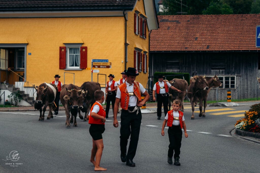
On our second trip, we also happened to catch several seasonal cattle drives. That connection between landscape and tradition is part of what sets Appenzell apart. Many trails intersect with transhumance routes, where farmers still move livestock between alpine pastures, a tradition that continues to shape both the scenery and the hiking experience today.

- When to Hike in Appenzell: May – October
- Trail Waymarking: Trails that are marked with white-red-white blazes signify moderate mountain trails while trails marked with white-blue-white blazes signify difficult alpine trails.
- Vocab: German Hiking Vocabulary
- What to Bring: Sun protection, sturdy hiking boots, swimming suit, reusable water bottle, and hiking poles.
- Closest Airport to Appenzell: Zurich (ZRH), Switzerland, and Memmingen (FMM), Germany
- Where to Stay in Appenzell Village: Alte Metzg – Hostel (budget), Blattenheimat (midrange), Hotel B&B Stossplatz (midrange), or Hotel Appenzell (luxury)
- Where to Stay in Weissbad Village: Weissbad Lodge (midrange), or Hotel Hof Weissbad (luxury)
- Where to Stay in Schwende: Hotel Frohe Aussicht (midrange)
- Recommended Trail Map: K+F 09, Appenzell, Säntis, St. Gallen 1:40.000
Appenzell Hiking Map
\The Appenzell Alps lie in northeastern Switzerland, near the borders of Liechtenstein, Austria, and Germany, spanning the cantons of Appenzell Ausserrhoden, Appenzell Innerrhoden, and St. Gallen.
The range includes the Alpstein massif, the Churfirsten chain, the Alvier Group, and the Speer–Mattstock Group. Of these, the Alpstein, with its three parallel chains, draws the most visitors.
The highest peak is Säntis (2502 m), followed by Girenspitz (2448 m) and Altmann (2436 m).
The Appenzell Alps are bordered by the Glarus Alps and the Rätikon Alps. Nearby highlights include the Liechtenstein Panorama Trail and the Rätikon High Trail Circuit.
1. Marwees to Meglisalp Circuit Hike

Marwees is the mountain that rises up between Lake Seealpsee and the valley of Widderalp in the heart of the Alpstein massif.
The demanding Marwees Ridge trail is my favorite day hike in the region. It follows both white-red-white (moderate) and white-blue-white (difficult) trails, suitable for surefooted mountain hikers who have stamina and no fear of heights. It’s important to only hike this trail in dry conditions and in stable weather.
Starting at the paragliding landing area next to the Wasserauen car park, follow the trail in the direction of Klein-Hütten (this is the same trail as Lake Seealpsee initially). At the Klein-Hütten trail junction, the Marwees hiking trail branches off to the left and ascends steadily to the Bogartenlücke mountain saddle.
From the Bogarten saddle, the way continues very steeply up a channel to the slopes of Marwees. A traverse brings you to the Marwees ridge. After a steep push to the Marwees Eastern Summit, the trail follows the narrow spine of Marwees with greater ease.
The ridge is an absolute joy to hike. You’ll see Widderalpstöck (2058 m), Hundstein (2157 m), Altmann (2435 m), Ebenalp (1640 m), Schäfler (1924 m), and many more peaks.
The path eventually skirts the highest summit of Marwees and descends to Widderalpsattel saddle, Bötzelsattel saddle, and then Meglisalp (mountain inn, mountain pasture, chapel). After a well-deserved lunch break at Berggasthaus Marwees, complete the circuit back to Lake Seealpsee and onwards to Wasserauen.
Trailhead | Wasserauen Train Station, or Wasserauen Car Park
Distance | 14.5 km circuit
Time Needed | 6:45 hours
Elevation Gain/Loss | 1225 meters
Difficulty | Difficult
Learn More: Marwees Ridge Hiking Trail
2. Hoher Kasten – Saxer Lücke – Fälensee Hike

Saxer Lücke (1650 m) is a gap along the eastern mountain ridge of the Alpstein Mountains. It serves as a mountain pass linking the Rhine Valley with Appenzellerland. Historically, a mule track led from Sax village in the Rhine Valley over the Saxer Lücke to Brülisau village.
The most spellbinding approach to Saxer Lücke begins atop Hoher Kasten, accessible by cable car from Brülisau village. Follow the Geological Panorama Trail across the undulating eastern ridge to Berggasthaus Staubern and then down to Saxer Lücke (3:20 hours).
As you approach Saxer Lücke, you’ll start to see the Kreuzberge mountains, a string of eight, pearl-colored vertical spires. This vantage point of Kreuzberg is one of the most sought-after photo spots in Switzerland.
From Saxer Lücke, the trail descends to Lake Fählensee (also spelled Fälensee), a dreamy body of water cradled by a succession of serrated peaks that look painted, and lakeside Berggasthaus Bollenwees (25 minutes).
The 2-hour descent to Brülisau via Lake Sämtisersee and Berggasthaus Plattenbödeli follows farm roads. On both occasions that we hiked this trail, we were surprised by how taxing the final descent is (especially for the knees).
Good to Know | You can also do an out-and-back hike to Saxer Lücke and Fählensee starting at Staubern. There’s a cable car that links Frümsen with Berggasthaus Staubern. This is the easier and shorter option, but only viable if you’re traveling with a car.
Starting Point/Ending Point | Hoher Kasten Valley Station, Brülisau
Trailhead | Hoher Kasten Mountain Station
Distance | 19.3 km point-to-point
Time Needed | 6 hours
Elevation Gain | 505 meters
Elevation Loss | 1385 meters
Difficulty | Moderate – Moderately-Difficult (because of the length)
Learn More: Hoher Kasten to Saxer Lücke Hike
3. Lisengrat Ridge Trail

Lisengrat is the ridge that connects Mount Säntis, the highest mountain in the Alpstein, with Mount Altmann, the third highest summit in the Alpstein.
The cable-secured Lisengrat ridge trail runs between Mount Säntis and Berggasthaus Rotsteinpass, the mountain inn that stands on the Rotstein mountain pass.
Everyone has a different comfort level with narrow airy trails and exposure. For us, this trail wasn’t difficult, because of the generous placement of fixed cables. The trail is exposed, but there’s no “total” exposure. You always have something to hold onto.
To start the hike, take the Säntis cable car from Schwägalp to Mount Säntis. The summit of Säntis is completely built-up with walkways, viewing platforms, a restaurant, tunnel system, and more.
The Lisengrat trail starts off dramatically, with a steep ascent up chiseled rock stairs, flanked by cables. After wrapping around a ledge, the trail continues across the wide, grassy ridge of Chalbersäntis. The trail carefully winds around limestone outcrops, along ledges, and up and down secured rock staircases to reach the Rotsteinpass mountain hut, backed by the Fliswand mountain wall.
2026 Update: The Säntis Cable Car will be closed from May 1, 2026 until late autumn 2026 due to extensive renovations. If you want to hike this trail, I recommend following our Alpstein High Trail Trek. The new cable car is projected to re-open in spring 2027
Starting Point/Ending Point | Säntis Cable Car Valley Station, Schwägalp
Trailhead | Säntis Cable Car Mountain Station
Distance | 5.1 km out-and-back
Time Needed | 2:30 hours
Elevation Gain/Loss | 400 meters
Difficulty | Moderately Difficult
Learn More: Lisengrat Ridge Trail Guide
4. Ebenalp to Berggasthaus Aescher Hike

Berggasthaus Aescher (Äscher is the German spelling) is a mountain inn built into the rock wall of Ebenalp in the Alpstein mountains.
Photos of this 19th century, cliff-hugging, timber hut have graced the covers of multiple travel magazines, including National Geographic. Though social media and print media have contributed to Äscher’s world-wide fame, Aescher has been a top attraction in Switzerland since the 18th century, due to its proximity to the Wildkirchli caves. These caves were used by Neanderthal hunters during the summer and by hibernating bears in the winter.
Thanks to the Wasserauen-Ebenalp cable car, it’s rather easy to get to Berggasthaus Aescher. From the mountain station, it’s only a 25-minute hike to the cliff hut. The trail gently descends across the Ebenalp mountain pasture to the entrance of the Eremitenhöhle Wildkirchli cave.
The trail curves down the illuminated cave on a wide, sturdy path, to the cave’s exit. The descent continues along a smooth ledge trail, secured with handrails, to the Aescher mountain inn.
Berggasthaus Aescher is open between May and November. You can order food and drinks throughout the day. You can also book an overnight stay in the hut.
Trailhead | Ebenalp Cable Car Mountain Station
Distance | 1.2 km out-and-back
Time Needed | 1 hour
Elevation Gain/Loss | 324 meters
Difficulty | Easy
Learn More: How to Get to Berggasthaus Aescher in Switzerland
5. Schäfler Ridge Hike

I recommend combining the hike to Berggasthaus Aescher with the hike to Schäfler Ridge.
From the Wasserauen-Ebenalp mountain station, it only takes 1:15 hours to hike to Berggasthaus Schäfer, the mountain inn that stands atop Mount Schäfler.
Just beyond the Schäfler mountain inn, there are glorious viewpoints of the northern chain of the Alpstein and the ridge that links Schäfler with Altenalptürm.
This is an easy, straightforward hike. From Ebenalp, hike up to Berggasthaus Ebenalp and follow the wide Zisler ridge to Alp Chlus (40 minutes). From this alpine hut, the trail climbs up the eastern flank of Mount Schäfler to reach the hut (35 minutes).
Most visitors will hike this trail out-and-back. However, it’s also possible to continue along the ridge trail towards Säntis. You can either descend to Lake Seealpsee via Altenalp mountain pasture, or even Berggasthaus Mesmer.
Trailhead | Ebenalp Cable Car Mountain Station
Distance | 5.5 km out-and-back
Time Needed | 2:15 hours
Elevation Gain/Loss | 372 meters
Difficulty | Easy-Moderate
Learn More: Schäfler Ridge Trail Guide
6. Lake Seealpsee Circuit Trail

Seealpsee, an attractive mountain lake ringed by forest and mountain pastures, is one of the best places to hike and swim in Appenzell.
There are two trails that lead from Wasserauen to Seealpsee: the upper Klein-Hütten trail and the lower valley trail (farm road). I recommend ascending the upper trail, because it’s the far more scenic approach.
To find this trail, locate the paragliding landing area, marked by a shipping container, next to the Wasserauen car park. The path angles up across the grassy meadow and ascends through a beach forest to reach the Klein-Hütten mountain pasture.
The path gently descends across a storybook landscape to the northeastern tip of the lake. Follow the trail that wraps around the lake to the Seealp mountain pasture and further to Berggasthaus Seealpsee and Gasthaus Forelle.
Follow the wide track in the direction of Wasserauen. At the Chobel junction, you can either hike up to Berggasthaus Aescher and Ebenalp (and then descend to Wasserauen by cable car), or continue following the road down to Wasserauen.
Trailhead | Wasserauen Train Station, or Wasserauen Car Park
Distance | 7.3 km circuit
Time Needed | 2:45 hours
Elevation Gain/Loss | 372 meters
Difficulty | Easy-Moderate
Learn More: Lake Seealpsee Hiking Trails
7. Alpstein High Trail: 3-Day Hut-to-Hut Hike

This 3-day Alpstein high trail trek runs along the high trails of the Alpstein mountains, starting in Wasserauen and ending in Brülisau (Hoher Kasten). You can navigate to the starting point and from the ending point easily with public transit.
This U-shaped route links together the most striking landscapes and attractions of the Alpstein massif, including Lake Seealpsee, the Aescher mountain inn, Ebenalp, the Schäfler ridge, the Altenalp Towers, Mount Säntis, Lisengrat ridge, the Rotsteinpass mountain inn, the Zwinglipass Hut, the Saxer Lücke saddle, the Kreuzberge viewpoints, Stauern mountain inn, and the Hoher Kasten summit.
Exclusively following white-red-white trails, this 33-km alpine hike is a great option for surefooted, fit mountain hikers who enjoy ridge paths and limestone terrain (uneven surface, scree, loose rocks, etc…).
It’s a moderately difficult route, which requires a head for heights and stamina. All exposed areas are well-secured with aids (fixed cables, rungs, etc…). No special equipment is needed aside from sturdy hiking boots and hiking poles. We recommend the Unisex Black Diamond Hiking Poles.
Alpstein Trek Overview
Stage 1 | Wasserauen to Berggasthaus Schäfler (9.9 km, 5 hours, 1346 meters elevation gain, 307 meters elevation loss).
Stage 2 | Berggasthaus Schäfler to Zwinglipasshütte SAC (10.6 km, 6 hours, 956 meters elevation gain, 882 meters elevation loss).
Stage 3 | Zwinglipasshütte SAC to Hoher Kasten (13 km, 5 hours, 703 meters elevation gain, 917 meters elevation loss)
Learn More: 3-Day Alpstein High Trail
8. Appenzell Alps Hut to Hut Hike

This 8-day hut-to-hut hike, offered exclusively by Alpenventures UNGUIDED, is a self-guided hiking tour of the Alpstein.
The 70-km route zigzags across the Appenzell Alps, taking in the most famous landmarks, trails, and huts along the way, including Lake Fälensee, the Geological Panorama Trail (Saxer Lücke to Hoher Kasten), the Schäfler Ridge, Heaven’s Ladder, and more.
Highlights of this hut-to-hut trail are staying in the cliffside Aescher hut, the ridge-straddling Tierwies hut, and the lakeside Bollenwees hut.
For a faster-paced itinerary, take a look at 6-Day Hut to Hut in Switzerland.
9. Swiss Whiskey Trek

The 8-Day Swiss Whiskey Trek is a thematic hut-to-hut hiking trail in the Appenzell Alps for Whiskey connoisseurs.
Along the route, hikers can sample unique whiskeys, which are aged in barrels located at or near the mountain huts. Each whiskey has a distinct flavor and color due to the type of barrel (American, Portuguese, French, or Russian Oak) and previous occupancy (sweet wine, Merlot, Gamay, Zweigelt, port, sherry, rum, plum brandy, etc…)
After completing the hut-to-hut hike, hikers are treated to a complimentary gift packet, which includes a bottle of whiskey, a bottle of beer, and a whiskey glass.
10. Easy Appenzell Hut Hike

Are you new to hut-to-hut hiking? Are you planning a trip with your adult parents, or with your children?
This easy 6-Day Appenzell Trek takes in the beauty of the Appenzell mountains, but bypasses all challenging terrain.
This carefully-crafted itinerary is 32-km long and steers hikers across the Appenzell Alps along easy-moderate hiking trails with minimal technical difficulty.
Where to Stay in Appenzell for Hiking

If you’re traveling without a car, I recommend staying in Appenzell, Weissbad, or Schwende, all situated along the Gossau-Wasserauen train line of the Appenzell Railways, so that you can access most trailheads with transit.
Appenzell Village

The charming town of Appenzell is the capital of the Swiss canton of Appenzell Innerrhoden. Set amid picturesque countryside, it’s a pretty town of colorful, gabled buildings housing bakeries, restaurants, hotels, apartments, and small museums. Hikers can take advantage of the regular train connections to Wasserauen and Weissbad (with a bus onward to Brülisau).
The best places to stay in Appenzell are Alte Metzg – Hostel (budget-friendly hostel with communal kitchen), Alte Metzg Boutique Pension (midrange guesthouse), Hotel B&B Stossplatz (B&B with free bike rental), Hotel Appenzell (3-star village center hotel), and Adler Hotel (3-star hotel with on-site restaurant).
Weissbad Village
Weissbad is a quiet village in Schwendetal Valley between Appenzell and Wasserauen.
Situated on the Gossau–Wasserauen train line of the Appenzell Railways, Weissbad is another great base for exploring the region. By train, it takes a mere 6 minutes to reach Appenzell village and 10 minutes to reach Wasserauen, the Ebenalp cable car valley station, Seealpsee trailhead, Marwees trailhead. And, it’s only an 8-minute bus ride to Brüllisau, the starting point of the Hoher Kasten – Saxer Lücke – Fählensee hike.
The best accommodation in Weissbad are 3-star Weissbad Lodge, located on the bank of the Sitter River, just a block away from the Weissbad train station and bus stop, and their sister property 4-star Hotel Hof Weissbad.
Schwende Village
Schwende lies in Schwendetal Valley, just south of Weissbad. This village is also located along the Gossau–Wasserauen train line, with direct connections to Wasserauen, Weissbad, and Appenzell.
The family-run Hotel Frohe Aussicht, which means “happy outlook,” is a hillside hotel and restaurant surrounded by beautiful countryside. It’s a short uphill walk from the Schwende train station to the hotel. Guests love the views and the restaurant!!!
More Swiss Alps Hiking Guides
Switzerland:
Zermatt:
- Zermatt Itinerary
- Where to Stay in Zermatt
- Best Hikes in Zermatt
- Gornergrat Hike
- Edelweissweg Hike
- Tufteren High Trail
- Charles Kuonen Suspension Bridge Hike
Lake Lucerne Region:
- 5-Day Lucerne Itinerary for Hikers
- Stoos Ridge Hike
- Walenpfad Panorama Trail
- 2-Day Stanserhorn-Engelberg Ridge Hike
Rätikon Alps:
- Rätikon Alps Circuit Trail in Austria and Switzerland


Pin this Image for Future Trip Planning!
Stay Connected:
Connect with us on Pinterest.
Follow us on Instagram.
Like us on Facebook.
Support Us:
If you love reading my content, you can send me a donation via paypal.

