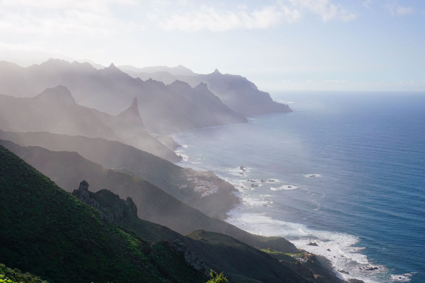
The Anaga mountains make up the oldest part of Tenerife, Spain.
Located in the northeastern tip of the island, this biodiverse region is one of the best places to hike in the Canary Islands.
From misty forest walks to exhilarating coastal trails, the Anaga massif offers scenic variety, solitude, and arguably the best views of Tenerife’s coastline. Anaga feels like a prehistoric paradise with its jungle-like laurel forest, whimsical dragon trees, and green-carpeted peaks and ravines.
If you want to spend a few days in Anaga Rural Park, we recommend basing yourself in either Santa Cruz de Tenerife, or La Laguna.
Keep reading to discover our favorite Anaga hiking trails.
Important: Access to these hiking trails keeps changing due to landslides and construction. We highly recommend visiting Centro de Visitantes del Parque Rural de Anaga at Cruz del Carmen to confirm whether these trails are indeed open during your visit.

Tips for Hiking in Anaga Rural Park
- Pack your lunch and sufficient water.
- Don’t leave valuables in your parked car.
- Use Maps.me (offline maps app) to locate trailheads.
- Secure a free permit if you want to see El Pijaral (The Enchanted Forest, Bosque Encantado)
- Purchase the Tenerife Rother Walking Guide.
- Be very cautious when hiking in the Anaga forest after rainfall. It’s slippery and dangerous.
- Rent a car if you want to do a lot of hiking in Anaga Rural Park. We recommend using the Discovercars.com car rental reservation platform to search for and book car rentals in Tenerife. Check car rental rates here.
- Where to Stay in Anaga Rural Park: Montes de Anaga Hostel (budget) in El Bailadero, or San Andres Beach Apartment (midrange) in San Andres
- Where to Stay in La Laguna: La Laguna Gran Hotel (midrange), or Hotel Boutique San Diego – Adults Only (luxury)
- Where to Stay in Santa Cruz de Tenerife: Hotel Taburiente S.C.Tenerife (midrange), or Hotel emblemático Hi Suites (luxury)
- Recommended Trail Maps: Tenerife Hiking Map Set WKE 7 (Freytag + Berndt)
Anaga Hiking Trails Map
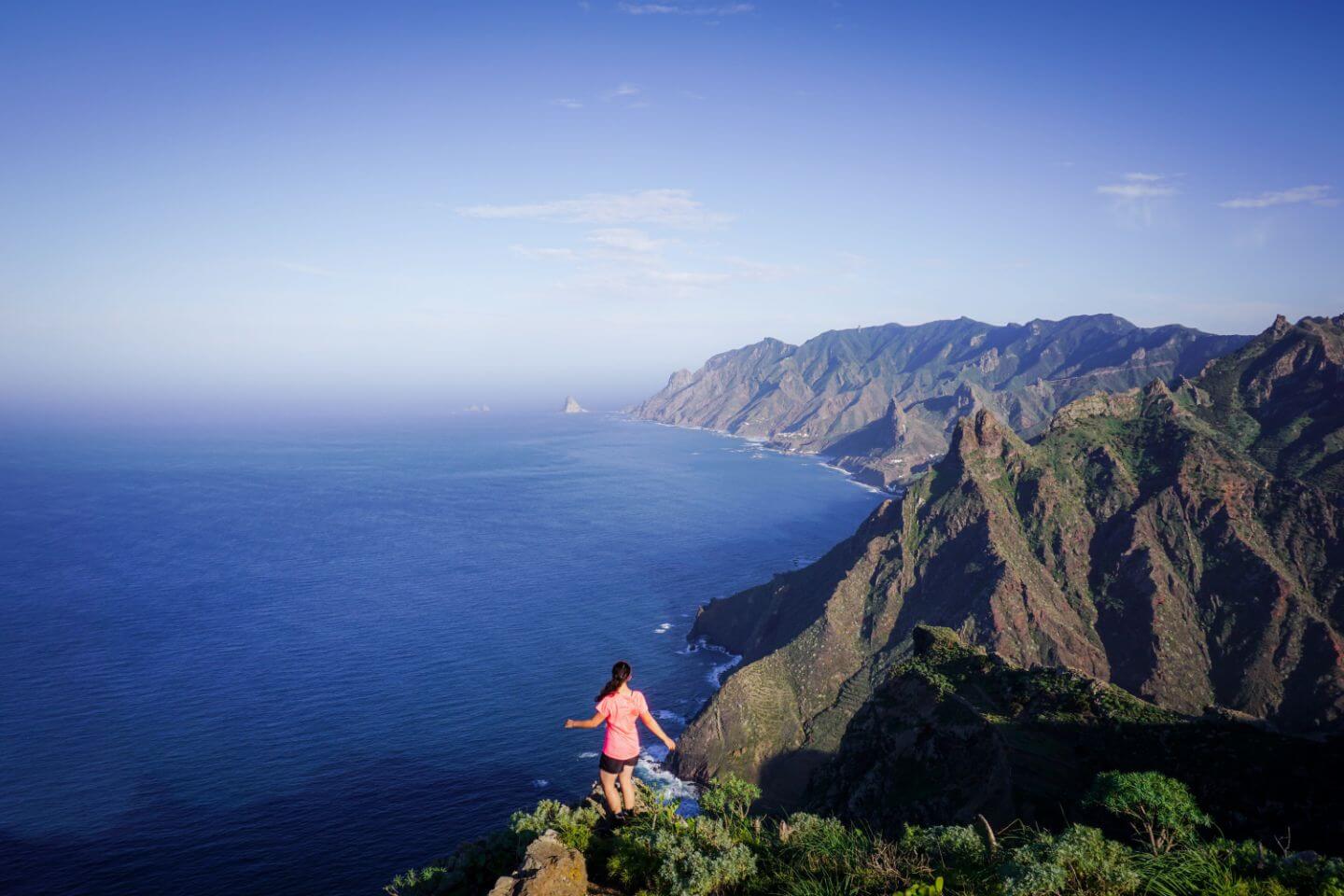
1. Benijo to Faro de Anaga Circuit Trail
This spectacular hiking route takes you to some of the most captivating corners of Parque Rural de Anaga. You’ll see tiny coastal hamlets where time stands still.
You’ll walk by dragon trees and see unbeatable views of the Anaga coastline. This is a long hike with some tricky sections, due to slippery terrain (e.g. wet leaves). Please be cautious.
The trail starts in Benijo. You’ll hike past the hamlets of El Draguillo and Las Palmas as you make your way to the Faro Punta de Anaga lighthouse.
From the lighthouse, you’ll continue to the village of Chamorga and walk through Laurel forest until joining a balcony trail back to Benijo.
For a shorter version of this hike, you can do a mini-loop. When you get to El Draguillo, turn right and follow signs to Chamorga (instead of heading to Las Palmas).
You’ll hike uphill for almost 1 km (270 m elevation gain) to an intersection. From here, turn right, and start the glorious return journey to Benijo.
Trail Stats
Trailhead | Benijo
Distance | 14.2 km circuit
Time Needed | 7 hours
Elevation Gain/Loss | 1432 meters
Difficulty | Difficult
Minimum Elevation | 79 meters
Maximum Elevation | 640 meters
Route | Benijo (hamlet) – El Draguillo (hamlet) – Las Palmas (hamlet) – Faro Punta de Anaga (lighthouse) – Tafada (mountain) – Chamorga (village) – Benijo (hamlet)
Where to Stay | Casanaga (budget) in Almáciga, or Vivienda Vacacional Casa Taganana (luxury) in Taganana
Learn more: Benijo to Faro de Anaga Circuit Trail Guide
2. Igueste to Atalaya de los Ingleses

Igueste de San Andrés is a small village north of Playa de las Teresitas. Huddled around Barraco de Igueste, this white-washed village is an exciting back entrance into the Anaga mountains.
When you drive to Igueste, follow the road to the other side of the Barranco (ravine). You’ll see lots of street parking along Calle Manuel Vera Álvarez, near the bus stop.
To find the trail, you’ll have to walk past a church and through a residential area. Initially, you’ll climb up a staircase and follow signs to El Semaforo on PR – TF 5. Once you’re on the trail, it’s impossible to lose it. Maps.me will help you locate the trailhead.
After steadily hiking uphill for about 300 meters (1.2 km), you’ll reach an intersection. Turn left here, following the sign to Atalaya de los Ingleses.
The right path will take you to El Semáforo de Igueste, which is an abandoned building and viewpoint. The views at El Semáforo are okay, not outstanding. So, no need to detour here.
Though short, we really loved this hike, because of the vegetation and the marvelous views of Igueste and the Anaga coastline.
As you gain elevation, the village looks like a white pearl mounted on a bloodstone setting. It’s spellbinding. You’ll see Mount Teide and Santa Cruz off in the distance.
The trail eventually plateaus. You’ll ascend along a ridge to a stone shelter called Atalaya de los Ingleses. From here, it’s a quick walk to an obvious lookout point.
At the lookout, you’ll be able to see Playa de Antequera. If you’re interested in a longer hike, you can continue all the way down to Playa de Antequera.
Tip | Start your hike in the morning for the best light and temperature. There is no shade along this trail, so you’ll be fried by the sun if you get a late start on a sunny day.
Trail Stats
Trailhead | Igueste de San Andrés
Distance | 5.5 km out-and-back
Time Needed | 3 hours
Elevation Gain/Loss | 691 meters
Difficulty | Moderate
Min. Elevation: 14 meters
Max. Elevation | 407 meters
Route | Igueste (village) – Atalaya de los Ingleses (abandoned stone shelter) – Viewpoint – Igueste (village)
Where to Stay | Steps to the beach (midrange) in Las Gaviotas, or San Andres Beach Apartment (midrange) in San Andres
3. Punta del Hidalgo to Chinamada and Las Carboneras Hike
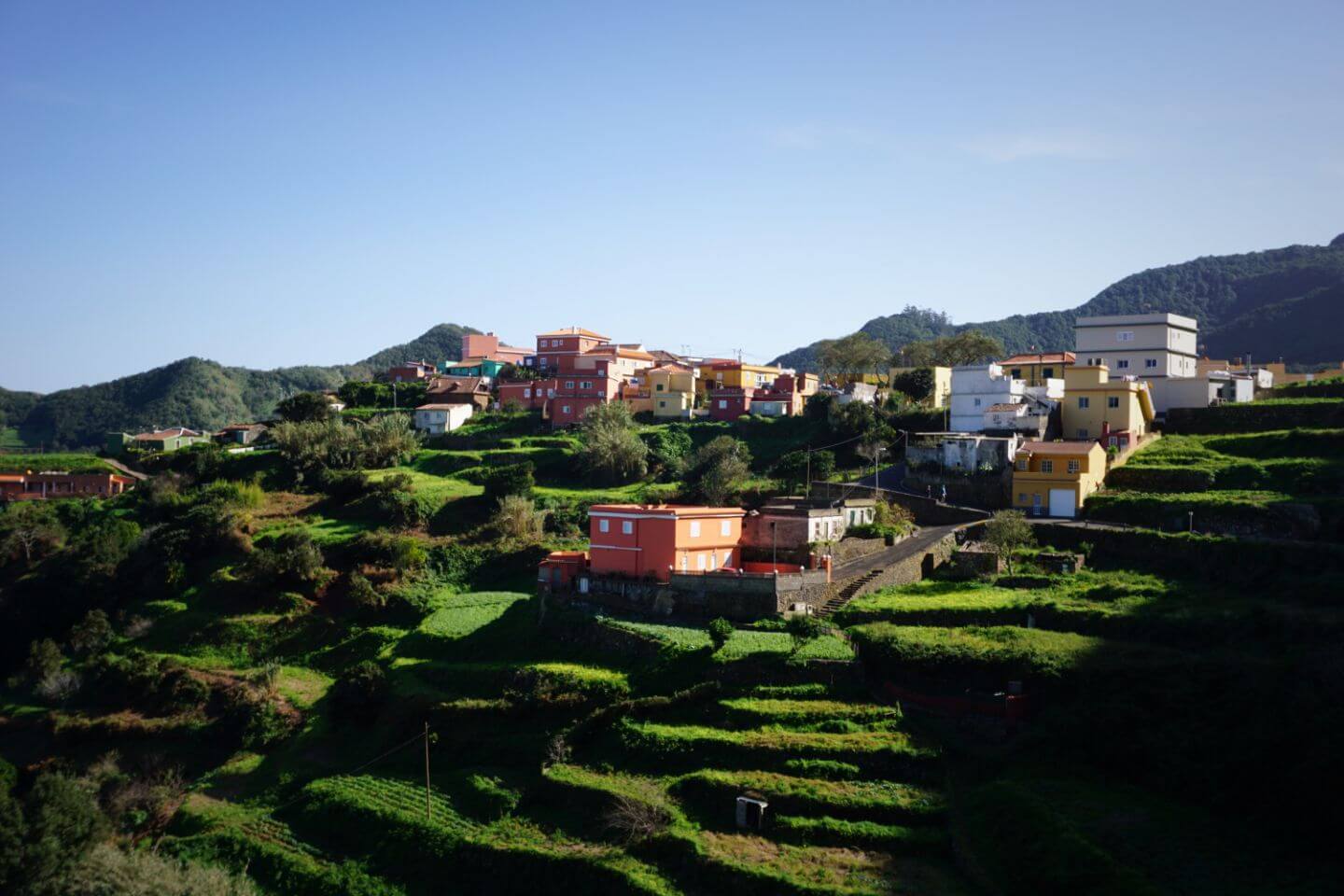
This Anaga hiking trail combines rugged mountain scenery with interesting cultural sites. You’ll get a glimpse into rural life in Anaga Rural Park as you walk past cave dwellings and terraced fields.
There are a few different ways to tackle this popular Tenerife hike. You can do an out-and-back hike starting and ending in Punta del Hidalgo (what we did). Or, you can start in Cruz del Carmen and hike all the way down to Punta del Hidalgo.
If you’re interested in the second option, park in La Laguna and take the bus to Cruz del Carmen. When you finish the hike, take another bus back to La Laguna.
From the lookout area Mirador Punta Del Hidalgo, follow the road towards Roque dos Hermanos. Continue on the walking path until you see a semi-derelict building, located at the floor of Barranco del Río.
From here, you’ll cross the stream and initially take the right trail (left leads to the beach) uphill. Next, take the broad hiking path (to the left) and start the steady ascent to Chinamada (2 hours needed), a village that’s famous for its cave dwellings.
As you gain elevation, you’ll pass a few lookout points. Shortly before arriving in Chinamada, you’ll pass some terraced farmland. When you arrive at Chinamada, treat yourself to a simple but delicious lunch at Restaurante La Cueva.
From Chinamada, you have a few options. You can detour to the Mirador Aguaide lookout point. You can also continue your hike to Las Carboneras, another remote hamlet in the Anaga mountains, which isn’t a must-do.
To get to Las Carboneras, follow the trail through las Escaleras to Degollada de las Escaleras. At the intersection, make a left and follow the trail for 20 minutes (710 m) to a paved road.
Turn left on the road and head down to Las Carboneras (~10 min). Walk through the hamlet and follow the road back down to Chinamada. The best part of this extension is seeing the terraced fields around Las Carboneras.
From Chinamada, head back to Punta del Hidalgo the same way you ascended.
Tip | After your hike, take a dip in the natural pool (Piscina Natural) at Punta del Hidalgo.
Trail Stats
Trailhead | Punta del Hidalgo
Distance | 15.6 km lollipop-circuit
Time Needed | 7 hours
Elevation Gain/Loss | 1577 meters
Difficulty | Difficult
Min. Elevation | 22 meters
Max. Elevation | 744 meters
Route | Punta del Hidalgo (village) – Chinamada (hamlet) – Las Carboneras (hamlet) – Chinamada (hamlet) – Punta del Hidalgo (village)
Where to Stay | Punta Paradiso (midrange) in Punta del Hidalgo, or Sunset Dream Bajamar (midrange) in Bajamar
4. Taganana to Playa de Tamadite

When we visited the Anaga Rural Park Visitor Center (Visitantes del Parque Rural de Anaga) at Cruz del Carmen, we were informed that the route from Afur to Playa de Tamadite was closed. Readers have informed us that the trail is now open, but please confirm with the visitor center.
Our original plan was to do the loop trail that starts in Afur and leads to Taganana, then to La Cumbrecilla, and ultimately back to Afur (13.1 km circuit, 5:45 hours, elevation gain/loss: 1070 meters).
With the trail closure, we opted for an out-and-back hike from Taganana to Playa de Tamadite.
The hike from the village of Taganana to the beach Playa de Tamadite hugs the coast the whole time, delivering continuous views of the spectacular Anaga coastline.
When starting in Taganana, the only tricky part is finding the trailhead. We parked near the village pharmacy. From here, it’s a 20-minute uphill walk to reach the trailhead.
Signage is very poor, so we relied on Maps.me. We didn’t drive all the way to the trailhead, because the village roads are very narrow and steep.
When you do find the trailhead, just continue straight, following the coastline. You’ll hike through a small wine-producing village called El Chorro. Shortly before arriving at the beach, you’ll cross the Barranco de Afur stream.
Playa de Tamadite is the perfect place to eat lunch and take a break, before starting the return journey back to Taganana.
Trail Stats
Trailhead | Taganana
Distance | 10 km out-and-back
Time Needed | 4:45 hours
Elevation Gain/Loss | 767 meters
Difficulty | Moderate
Min. Elevation | 24 meters
Max. Elevation | 330 meters
Route | Taganana (village) – El Chorro (hamlet) – Playa de Tamadite (beach) – El Chorro (hamlet) – Taganana (village)
Where to Stay | Casanaga (budget) in Almáciga, or Vivienda Vacacional Casa Taganana (luxury) in Taganana
5. Roque de Taborno
Roque de Taborno is a thumb-shaped rock that rises 706 meters above sea level on the north coast of the Anaga peninsula.
While seeing “Tenerife’s Matterhorn” is certainly a highlight, the real treat is the dramatic coastal views. It looks like the Anaga mountain range is rippling into the sea.
To start this hike, head to Taborno, a tiny hamlet located deep in the Anaga Rural Park. In this tiny settlement, you’ll find a bar (Casa Hilario), a restaurant (Historias para no dormir), and a small chapel.
From the village’s main road, continue walking to the chapel. After passing on the right side of the chapel, descend a few meters to a viewpoint.
The trail continues to another viewpoint Mirador sobre Barranco La Fajana. You’re going to follow the circular route around Roque de Taborno clockwise.
When you’re about 180 degrees around, there’s a spectacular vantage point of the craggy Anaga coast. Complete the circuit and follow the trail back to Taborno.
Trail Stats
Trailhead | Taborno
Distance | 4 km lollipop-circuit
Time Needed | 1:50 hours
Elevation Gain/Loss | 381 meters
Difficulty | Moderate
Min. Elevation | 505 meters
Max. Elevation | 635 meters
Route | Taborno (hamlet) – Mirador sobre Barranco La Fajana (lookout point) – Era de los Cardos (lookout point) – Taborno (hamlet)
Where to Stay | La Laguna Gran Hotel (midrange), or Hotel Boutique San Diego – Adults Only (luxury) in San Cristóbal de La Laguna
6. Path of the Senses Forest Walk

Directly from Cruz del Carmen, you can embark on a short hike through Anaga’s lush laurel forest.
Starting from the parking lot, look for signs to “Trail of the Senses.”
You can choose between 3 different walks, all with varying lengths. The longest walk is 30 minutes.
Trail Stats
Trailhead | Cruz del Carmen (Elevation: 950 m)
Distance | 0.5 – 1.5 km circuit
Elevation Gain/Loss | Minimal
Difficulty | Easy
Time Needed | 10 – 30 minutes
Where to Stay | La Laguna Gran Hotel (midrange), or Hotel Boutique San Diego – Adults Only (luxury) in San Cristóbal de La Laguna
Best Base for Hiking in the Anaga Mountains
San Cristóbal de La Laguna
San Cristóbal de La Laguna, or simply La Laguna, is located inland, 10.5 km from Santa Cruz de Tenerife.
If you stay in La Laguna, you’re well-positioned to reach Punta del Hidalgo, Cruz del Carmen, and the Anaga Mountain Road. You can also use local buses to reach trailheads and do point-to-point hikes, like Cruz del Carmen to Punta del Hidalgo.
Furthermore, La Laguna is one of Tenerife’s most charming cities, offering plenty of dining options amidst Spanish colonial architecture. During your visit, don’t miss out on the city’s bustling marketplace: Mercado Municipal de San Cristobal de la Laguna.
Budget | Casa Del Casco Historico is a centrally located guesthouse in La Laguna, walking distance to many restaurants and cafés in the historic center. Guests have access to a shared kitchen, lounge, garden, and terrace. Coffee, tea, and cookies are provided.
Midrange | La Laguna Gran Hotel is a top-rated hotel in the heart of La Laguna’s old town, featuring a stylish lobby entrance, clean and spacious bedrooms, a rooftop pool (seasonal), and an on-site restaurant. Highlights of staying here are the central location, breakfast buffet, and the warm and friendly atmosphere. You can park in the hotel’s parking garage (extra charge), or in a free car park behind the hotel.
Luxury | Hotel Boutique San Diego – Adults Only stands out with its elegant, yet cheerful interior design, intimate atmosphere, and lovely gardens. Guests love the breakfast featuring local products, the spacious and modern bedrooms, and the helpfulness of the hosts (booking dinner reservations and taxis, personal recommendations). The hotel is a 10-15 minute walk to the old town.
Look for accommodation in La Laguna.
Santa Cruz de Tenerife
Though not as photogenic as La Laguna, Santa Cruz de Tenerife feels genuine and local. Seeing the sunrise over the ocean each morning was a real treat.
Also, if you stay in Santa Cruz de Tenerife, it’s easy to access Playa de Las Teresitas (Tenerife’s most beautiful beach), the white-washed village of Igueste de San Andrés (trailhead), and TF 134 (scenic road to Taganana and Benijo).
Budget | Casa Weyler is a friendly and centrally located bed and breakfast in Santa Cruz. Guests have access to a large communal kitchen and lounge and balcony (6th floor) with mountain and sea views.
Midrange | EDI Astoria impresses easily with its bright and cheerful interior. Each modern unit has it’s own fully equipped kitchen and dining space. EDI Astoria is located in the center of the city, which is very convenient, but it can also get noisy at night.
Luxury | Monkey House (3 nights minimum stay) is the best option for a family. This gorgeous 3 bedroom, 2 bathroom apartment is modern, impeccably clean, and well-equipped. Free private parking included.
Look for accommodation in Santa Cruz de Tenerife.
Read Next: Where to Stay in Tenerife for Hiking
Keep Reading about Tenerife
Tenerife Travel & Hiking:
Anaga Rural Park:
Teide National Park:
Teno Rural Park:

Spain Trip Planning
Use our Spain Travel Guide and Spain blog archive to plan a unique and memorable trip to Spain.
When to Visit Spain
Spain is an all-year-round destination.
In summer, we recommend visiting Picos de Europa National Park in Northern Spain.
In spring and fall, we recommend traveling to Mallorca. Read April in Mallorca.
In winter, we recommend visiting the Canary Islands. Read January in Tenerife.
Getting around Spain
We always rent a car when traveling in Spain. Use these road trip itineraries for trip planning inspiration:
- Picos de Europa, Northern Spain Road Trip
- Mallorca Road Trip
- Tenerife Road Trip
- Gran Canaria Road Trip
Car Rental
We recommend using the Discovercars.com car rental reservation platform to search for and book car rentals in Spain. This easy-to-use booking platform compares car rental deals from 500+ trusted providers, so that you can choose the best option for your trip.
Hiking in Spain
We love hiking in Spain, because of the country’s varied alpine, coastal, and volcanic landscapes. Read these region-specific hiking guides:
What to See & Do in Spain
- Stay in a Finca on Mallorca like Mirabó de Valldemossa is Valldemossa, Finca Ca’s Curial – Agroturismo – Adults Only in Soller, or Son Brull Hotel & Spa in Pollenca.
- Hike the Ruta del Cares gorge trail in the Picos de Europa mountains.
- Hike around the highest mountain in Spain, Mount Teide, in Teide National Park in Tenerife.
- Hike in the dazzling, prehistoric-looking Anaga Rural Park in Northern Tenerife.
- Hike to Güi Güi Beach, the most pristine beach in Gran Canaria.
- Visit the charming town of Potes in Cantabria, Northern Spain.
- Visit the Sanctuary of Covadonga and Lakes of Covadonga in Asturias, Northern Spain.

Pin this Image for Future Trip Planning!
Stay Connected:
Connect with us on Pinterest.
Follow us on Instagram.
Like us on Facebook.
Support Us:
If you love reading our content, you can buy us a coffee via Ko-Fi.


Hi, this was amazing. So happy I found this page. Great detail and information. I did 3 of the hikes with no issue. Thank you!!
Hi Dane,
Happy to hear you had a good time hiking in Anaga!
-Sabrina
Super helpful. By any chance do you suggest a guided walk or a tour, I’m. It too good at geography on my own but it will be great if I could get help tomorrow or day after
Kind regards,
Ruchika
Hi Ruchika,
We don’t have any info re: guided tours. Maybe someone at the Cruz de Carmen Visitor Center may be able to help.
Best of luck,
Sabrina