Thanks to its island territories and vast coastline, Spain is an all-year-round hiking destination. From the volcanic landscape encircling El Teide to the limestone mountains of Picos de Europa National Park, every Spanish hiking destination feels wholly unique, both scenically and culturally.
A trail lover can never tire of hiking in Spain.
Kati and I have spent months hiking in various destinations across Spain: specifically Galicia, Asturias, Cantabria, Mallorca, Tenerife, and Gran Canaria. Below, I’ve summarized our absolute favorite hikes in Spain to date.
We hope to uncover more of Spain’s beautiful wilderness in the years to come, especially the Pyrenees, Costa Brava, Sierra de Guadarrama, and Montserrat. In the comment section, please share with us your favorite hiking trails in Spain.

- Where to Hike in Summer: Picos de Europa Mountains
- Where to Hike in Spring and Autumn: Balearic Islands and Galicia
- Where to Hike in Winter: Canary Islands
1. Camiño dos Faros Coastal Trek, Galicia
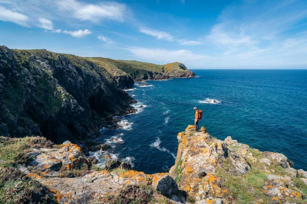
The Camiño dos Faros, or Lighthouse Way, is a 200-km trail that runs along the Costa da Morte (Coast of Death) in Galicia. This village-to-village hike connects historic lighthouses and traditional fishing villages, traversing granite cliffs, secret beaches, and wind-swept dunes along the way.
The beauty and thrill of this trail lies in its commitment to the coast. It rarely strays from the coastline, and traces pathways that are still used by fishermen and percebes (goose barnacle) harvesters today
The full trek is typically divided into 8 demanding stages, though it can easily be adapted with taxi transfers, shortcuts, or shorter sections. Kati and I hiked this trail in May and did cut out two sections to make it more manageable.
Read my guide to trekking the Camiño dos Faros and where to stay along the Camiño dos Faros to start planning your Lighthouse Way adventure.
The Self-Guided Option…
After hiking the Lighthouse Way and fielding questions about shorter options, customizations, and luggage transport, it became clear that many hikers would benefit from professional support.
That led us to On Foot Holidays, a UK-based leader in ethical, self-guided walking holidays across Europe. They take care of accommodations, luggage transfers, and end-to-end transport, offer flexible 5-, 7-, and 10-night itineraries, and can arrange taxi shortcuts to ease tougher stages.
Their excellent offline navigation app and thoughtful planning make the Lighthouse Way far more approachable without sacrificing independence. I summarized all the benefits of booking this trip with them in why book a self-guided Lighthouse Way trek.
Exclusive offer: First-time On Foot Holidays customers can claim a £20 voucher by entering coupon code M&H20 in the “Promotional or voucher code” field on any inquiry or booking form.

2. Refugio Jou de los Cabrones 2-Day Hike, Picos de Europa Mountains

Picos de Europa National Park extends across the Northern Spanish regions of Asturias, Cantabria, and León (Castile and León). It comprises the awe-inducing Picos de Europa Mountains, a limestone mountain range composed of three massifs, rising to a height of 2650 meters.
I strongly believe that the best way to experience the Central Massif is by following this demanding 2-Day Refugio Jou de los Cabrones hike, which starts in Bulnes above Poncebos.
The route ascends the Llanos del Tornu plain and then continues up the impossibly steep Canal de Amuesa to the Amuesa mountain pasture. Next, the trail climbs up the La Cuesta del Trave slope and across an undulating high-alpine karst rockscape to reach the hut.
Refugio Jou de los Cabrones (2034 m) occupies a lonesome, but beautiful location in a depression, ringed by peaks. It’s the highest of the 9 managed mountain huts in the national park. Hikers can either stay in the refuge, with advance booking, or camp.
The next day, the trail leads through a maze of limestone down to Refugio de Urriellu, the hut located at the base of Naranjo de Bulnes peak. From this managed refuge, the trail descends with greater ease to Refugio de la Terenosa and the sprawling pastures around Collado de Pandébano. The final stretch leads back to Bulnes.
Distance | 20.6 km circuit
Time Needed | 2 Days
Elevation Gain/ Loss | 1955 meters
Difficulty | Difficult
Where to Stay in Poncebos Before/After Trek | Hostal Poncebos, Arcea Hotel Mirador de Cabrales, or Hotel Garganta del Cares
3. Ruta de Cares Gorge Trail, Picos de Europa Mountains

The most celebrated hike in Picos de Europa is the Ruta del Cares trail (PR-PNPE 3), which leads through the Cares gorge from Poncebos in Asturias to Caín in León.
Here, massive limestone walls, spangled with holm pack, rise vertiginously around the Río Cares river bed. High above the river, the chiseled trail contours around the walls of the mountains.
Though there’s no technical difficulty, the hike is very long, measuring 23.6 km out-and-back. Hikers should be comfortable along wide ledges with no barriers and a sheer drop on one-side.
We started the hike in Poncebos, but it’s also possible to begin in Caín.
Distance | 23.6 km out-and-back
Time Needed | 6:45 hours (8 hours with breaks)
Elevation Gain/Loss | 660 meters
Difficulty | Moderate
Where to Stay in Poncebos | Hostal Poncebos, Arcea Hotel Mirador de Cabrales, or Hotel Garganta del Cares
Hiking-Inspired Itinerary | Picos de Europa Road Trip
More Trails | Best Hikes in Picos de Europa
4. San Pedro to Agaete Hike, Gran Canaria

Gran Canaria, the third largest Canary Island, is a premier winter hiking destination. During our 3-week trip, we were impressed by the excellent trail conditions and ubiquitous trail signage across the island.
One of my favorite hiking areas in Gran Canaria is Agaete Valley, a green oasis in the northwest. While most of Gran Canaria is barren and arid, Valle de Agaete is lush and verdant.
This point-to-point day hike starts in the hamlet of San Pedro in Agaete Valley. Because this is a linear hike, we recommend leaving your car in Puerto de las Nieves/Agaete, and taking Global Bus 102 to San Pedro.
From San Pedro, the trail climbs up to Era de Berbique, an old threshing floor, and then gradually descends to Puerto de las Nieves, the port of Agaete.
This scenic San Pedro-Agaete trail affords sweeping views of Agaete Valley, the Riscos de Tamadaba, Roque Faneque cliffs, and the northwest coast of Gran Canaria. The views are tremendous.
If you want to end the day with a swim, you can extend the hike to Guayedra Beach, a wild black sand beach near Puerto de las Nieves. If you’re staying in Agaete for a few days, also consider hiking Agaete Valley to Tamadaba Pine Forest Trail.
Distance | 8.3 km point-to-point
Time Needed | 4 hours
Difficulty | Moderate
Where to Stay in Agaete | Casa Calma Yoga Guesthouse (budget), Hotel Puerto de Las Nieves (midrange), or Hotel & Spa Cordial Roca Negra (luxury)
Hiking-Inspired Itinerary | 7-Day Gran Canaria Road Trip
More Trails | Best Hikes in Gran Canaria
5. Cruz de Tejeda to Cuevas del Caballero Caves, Gran Canaria

When planning a hiking trip to Gran Canaria, we recommend dividing your time between Agaete and Central Gran Canaria. The latter is home to the highest mountains and the most striking rock formations on the island, including Pico de las Nieves, Roque Nublo, and Ventana del Nublo.
My favorite hike in Central Gran Canaria is the Cruz de Tejeda to Cuevas del Caballero trail, a scenic path with sweeping views of the cliffs and deep ravines of the collapsed volcanic crater of Tejeda.
This trail, which can be extended to Artenara, traces one of Gran Canaria’s restored royal pathways, which were used by the Pre-Hispanic inhabitants to move and transport goods, before the advent of roads.
Starting at the Cruz de Tejeda car park, this route follows a high trail to the Mirador Degollada de las Palomas viewpoint and then onwards to the fertility caves of Cuevas del Caballero.
The return route wraps around Montaña de Los Moriscos, following a wide track through a beautiful Canary pine forest.
Tip | Many hikers choose to stay at Parador de Cruz de Tejeda to tackle the many trails in the area including Cruz de Tejeda – La Culata Circuit.
Distance | 7 km lollipop-circuit
Time Needed | 3 hours
Difficulty | Easy
Where to Stay | Parador de Cruz de Tejeda (hotel) in Cruz de Tejeda, Hotel Rural Fonda De La Tea (B&B), or Vivienda Vacacional La Portada (apartment) in Tejeda.
6. Roques de Garcia, Teide National Park

Tenerife, the largest island in the Canary Islands, rarely needs an introduction. This volcanic island is home to the highest mountain in Spain, Mount Teide (3715 m).
The imposing volcano towers above Las Cañadas caldera, a rugged Mars-like landscape covered in petrified lava, craggy outcrops, and plains of pumice.
The most striking attraction across the vast crater floor is Roques de Garcia, a rock formation that stretches for nearly 2 kilometers between the western and eastern half of the caldera. Roques de Garcia is composed of bizarre rock towers and craggy pillars like the Roque Cinchado, known as the Finger of God.
In under 2 hours, hikers can follow a well-groomed hiking trail around the Roques de Garcia rock formation. The hike starts at the viewpoint Mirador de la Ruleta, directly across from Parador de Cañadas del Teide Hotel.
Given the accessibility of this trail, it’s best to undertake this hike first thing in the morning, or at the end of the day.
While visiting Teide National Park, we also recommend the Montaña Guajara Circuit Trail and the Montaña de la Botija and Montaña Samara Circuit Trail, which I summarized in my Teide National Park hiking guide.
Distance | 4.2 km circuit
Time Needed | 1:30 hours
Elevation Gain/Loss | 170 meters
Difficulty | Easy
Where to Stay in Teide National Park | Parador de Cañadas del Teide Hotel
Hiking-Inspired Itinerary | 7-Day Tenerife Road Trip
Best Places to Stay for Hiking | Where to Stay in Tenerife for Hiking
More Trails | Best Hikes in Tenerife
7. Benijo Circuit, Anaga Mountains, Tenerife

Much of the appeal of hiking in Tenerife lies in its diverse landscapes. Nestled in the northeastern tip of the island, Anaga Rural Park captivates with its deep ravines, laurel forests, and unique pinnacles. In contrast to the barren interior, Anaga is layers and layers of green-carpeted mountains unfurling into the ocean.
Some hikes in Anaga lead to wild beaches and remote villages, while others lead to panoramic viewpoints and through dense forests.
There are many great hiking trails in Anaga Rural Park including Igueste to Atalaya de los Ingleses out-and-back trail, Punta del Hidalgo – Chinamada – Las Carboneras out-and-back trail, Taganana to Playa de Tamadite out-and-back trail, Roque de Taborno Circuit Trail, and Benijo Circuit Trail.
We recommend hiking all of them, starting with the Benijo circuit path that leads to Faro de Anaga lighthouse and up to Chamorga. For a complete description, read our Benijo hiking guide.
Distance | 14.2 km circuit (shorter variation possible)
Time Needed | 7 hours
Elevation Gain/Loss | 1432 meters
Difficulty | Difficult
Where to Stay in Anaga Rural Park | Montes de Anaga Hostel (budget) in El Bailadero, or San Andres Beach Apartment (midrange) in San Andres
Where to Stay in La Laguna | La Laguna Gran Hotel (midrange), or Hotel Boutique San Diego – Adults Only (luxury)
8. Tossals Verds Circuit Trail, Mallorca

The Serra de Tramuntana mountain range extends across the west flank of Mallorca, the largest of the Balearic Islands in the Mediterranean Sea.
This rugged limestone range entices hikers from across Europe, particularly in spring and autumn, when temperatures are cool and the weather is mostly stable.
My favorite day hike in Mallorca is the Tossals Verds circuit trail, which widely wraps around Puig des Tossals Verds peak in the central Tramuntana Mountains. To begin this Mallorca hike, drive to Cúber Reservoir, located along the scenic Ma-10 road, 30 minutes from Sóller.
Consistently marked and easy-to-follow, this circular path starts by ascending to Coll de sa Coma des Ases (saddle) with views of Cúber and Gorg Blau Reservoirs. Beyond the saddle, the way steadily descends through a high valley towards the Torrent d’Almedra (also spelled Torrent d’Almadrà) stream.
A secured passage helps hikers scale the rocky step of Pas Llis (640 m). Next, the undulating Tossals Verds path traverses rocky limestone terrain, before entering a beautiful terraced olive grove. From here, it’s a short jaunt to Refugi Tossals Verds.
From the refuge, follow GR 221 towards Ses Casses Velles. After hiking through an oak forest and along a stream, the final stretch of trail follows the Canal des Embassaments (water canal) back to Cúber Reservoir.
Distance | 11.4 km circuit
Time Needed | 4:30 hours
Elevation Gain/Loss | 511 meters
Difficulty | Moderate – Moderately Difficult
Where to Stay in Fornalutx | Can Pera Accommodation – TI (midrange), or Hotel Apartament Sa Tanqueta De Fornalutx (luxury)
Where to Stay in Sóller | Hostel Sóller – Albergue Juvenil (budget), Hotel El Guía (midrange),Ecocirer Healthy Stay (vegan boutique B&B), and Finca Ca’s Curial – Agroturismo – Adults Only (luxury)
Hiking-Inspired Itinerary | 7-Day Mallorca Road Trip
More Trails | Best Hikes In Mallorca
More Spain Hiking Trails
Picos de Europa Hikes:
Mallorca Hikes:
- Cornador Gran Day Hike
- Puig de l’Ofre Peak Hike
- Talaia d’Alcúdia and Platja des Coll Baix Circuit Trail
- La Trapa Viewpoint Hike
- Castell d’Alaró Rock Castle Hike
- Path of the Archduke
Gran Canaria Hikes:


Pin this Image for Future Trip Planning!
Stay Connected:
Connect with us on Pinterest.
Follow us on Instagram.
Like us on Facebook.
Support Us:
If you love reading our content, you can buy us a coffee via Ko-Fi.

