Sass de Putia (Peitlerkofel in German, Sas de Pütia in Ladin) is a solitary, two-headed mountain in the Dolomites, situated between Val Badia (Gadertal) and Val di Funes (Villnösstal) in Puez-Odle Nature Park.
The moderate circuit trail around Sass de Putia (2875 m), which is called Roda de Pütia in Ladin and Rundweg Peitlerkofel in German, is one of the most gratifying day hikes in the Dolomites.
Starting at Passo delle Erbe, this 12.8 km loop hike takes 4 hours to complete without breaks. The loop trail traverses high alpine pastures, a steep gully, and mixed forests of stone pine and larch.
Kati and I hiked the Sass de Putia circuit three times (twice in July, once in October). During our second visit, we combined the loop trail with the ascent to the Sass de Putia summit. The final stretch to the Sass de Putia peak is a secured path (Via Ferrata Grade A).

- Trailhead: Passo delle Erbe, Alta Badia, South Tyrol | Google Maps
- Distance: 12.8 km circuit
- Time Needed: 4 hours. With lunch, a coffee break, and other breaks, it took me 5 hours.
- Elevation Gain/Loss: 640 meters
- Difficulty: Moderate
- Minimum Elevation: 1959 m
- Maximum Elevation: 2357 m
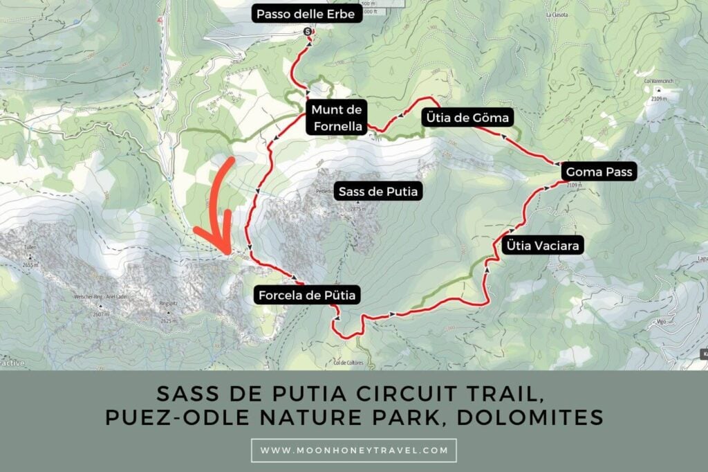
- Route: Passo delle Erbe (2006 m) – Forcela de Pütia (2362 m) – Ütia Vaciara (2118 m) – Gömajoch (2100 m) – Ütia de Göma (2030 m) – Munt de Fornella (2067 m) – Passo delle Erbe (2006 m)
- Trails: 8A, 4, 4B, 35, 8B, 8A
- Where to Stay at Passo delle Erbe: Ütia de Börz (midrange)
- Where to Stay in Val di Funes: Appartements Pension Sonia (budget), Fallerhof (budget), Hotel Fines (midrange), Proihof (midrange), or Hotel Tyrol (luxury)
- Recommended Trail Map: Tabacco 030 Bressanone – Val di Funes
Sass de Putia Hiking Map
Essential Trail Info
Trailhead | The Sass de Putia loop hike starts at the Passo delle Erbe (Würzjoch in German, Jü de Börz in Ladin) mountain pass.
How to Get to Passo delle Erbe | Passo delle Erbe is accessible from both Val Badia and Val di Funes. From San Martino in Badia (San Martin de Tor), the drive to the pass takes about 25 minutes (14.2 km). From San Pietro (St. Peter) in Val di Funes, it’s roughly a 30-minute trip (16.8 km). Both mountain roads leading up to the pass are extremely narrow and windy. We don’t recommend driving these roads at night. If you want to catch the sunrise, or sunset at the pass, it’s best to stay overnight at Ütia de Börz.
Parking at Passo delle Erbe | During high season, there’s a parking fee to park either at the pass, P1 car park (preferable), or in the P2 car park, just below the pass. During my last visit, it was 8 EUR to park between 7 am and 2 pm. Upon entering the parking area, the parking attendant collected the payment in cash or card upon entering the parking area.
Transit to Passo delle Erbe | Passo delle Erbe is also accessible by bus. Though, some buses only operate during high summer season.Use the suedtirolmobil website to find your connection.
Trail Direction | It’s best to hike this loop counter-clockwise, starting with the ascent to Forcela de Pütia (Peitlerscharte). There are two advantages to doing it this way. First, you tackle the most demanding stretch, the 260-meter climb to the saddle, at the beginning of the hike. Second, the scenery unfolds more gracefully in this direction. From Forcela de Pütia, the trail descends with sweeping views of the Sass dla Crusc massif.
Difficulty | Moderate
Trail Variations | From Forcela de Pütia (Peitlerscharte), you can make a side trip to the summit of Sass de Putia. The final exposed section is secured with fixed cables. This route is sometimes classified as a Sentiero Attrezzato (protected trail) and sometimes as an easy Via Ferrata Grade A. Regardless, we do recommend wearing a climbing helmet. Feel free to bring your full via ferrata kit for additional security. It’s also possible to extend this hike to Rifugio Genova, but I don’t think that’s necessary, since there are many alpine pasture huts along the trail.
Where to Eat | Munt de Fornella, Ütia Vaciara, and Ütia de Göma. During my last visit, I ate a nice meal at Ütia Vaciara, which is located around the halfway point. We’ve also eaten at Ütia de Göma, which serves hearty Ladin food. Surrounded by highland cows, Munt de Fornella, located at the northern base of the mountain where the circuit starts and ends, is popular with families.
Responsible Hiking | Stay on marked trails.
When Can You Hike around Sass de Putia
Early June until late October, depending on snow conditions. We’ve hiked this trail in July and October.
October is still a promising month to hike around Sass de Putia, but if it snows, the snow may linger, especially along the gully leading up to Forcela de Pütia. We hiked the circuit in early October after a snowstorm. It was doable, but there were some slippery passages.
We also recommend timing your hike with the opening times of the alpine pasture huts, which are generally open from early/mid June until mid-October. Note: opening times will vary depending on the weather and snow conditions.
Sass de Putia Circuit Trail Directions
Passo delle Erbe to Forcela de Pütia (1:30 hours)

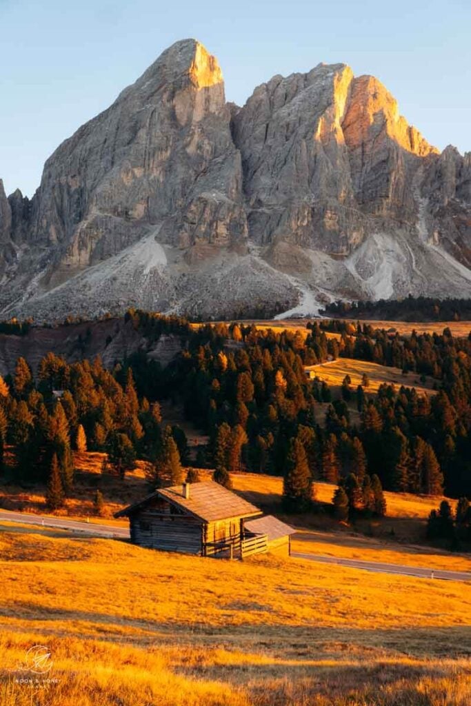
As soon as you arrive at the Passo delle Erbe pass, the impressive dolomite massif captivates. You’ll be thrilled to start this hike with such immediate gratification.
Locate the trail signs at the Passo delle Erbe parking lot. From here, follow the well-groomed wide gravel road in the direction of Forcela de Pütia (Trail 8A).
After gently ascending through a stone pine forest for about 20 minutes on a strip of land that feels like a natural causeway, you’ll reach a mountain pasture, located at the base of Sass de Putia’s northern slopes. Here, Munta de Fornella is just to the left and Ütia Sot Pütia is just off to the right.
The Sass de Putia circuit trail begins here. I recommend hiking counter-clockwise around the mountain. Therefore, turn right in the direction of Forcela de Pütia, signed 1:10 hours.

The track is initially wide and flat, but narrows quickly. Wrapping around Sass de Putia, you’ll follow an undulating balcony path, with views of Val di Lüsen (Lüsner Tal) valley below and the striking Odle di Eores (Aferer Geisler) mountain group directly ahead.
Though there is some erosion impacting the path, it’s still in good condition.

At the next trail intersection, continue on trail 4 towards Forcela de Pütia (Peitlerscharte), signed 40 minutes.
For the first time, the trail ascends very steeply up a broad rock- and scree-filled gully. It’s a 260 meter ascent to the Forcela de Pütia saddle. At times, red dot waymarks guide you into the bed of the stream. Other parts of the path are reinforced with timber.

Though careful footing is necessary, the path itself isn’t overly difficult. That being said, the ascent is relentless. On a hot summer day, the sun beats down mercilessly here.
In October, this whole passage was covered in snow.
Optional Ascent to Sass de Putia Peak (1:30 hours out-and-back)

At Forcella de Putia, the trail forks. To continue following the loop trail, take the middle track (4B) in the direction of Lungiarü and Roda de Pütia. The left trail takes you to the summit of Sass de Putia (1-hour one-way). The right trail leads to Rifugio Genova/Schlüterhütte (30 minutes).
The trail steadily zigzags up the mountain continuously. After about 35 minutes, the trail divides. The left path leads to Piccolo Sas de Putia/Kleiner Peitlerkofel (2813 m). The right trail, almost entirely secured with fixed cables (grade A via ferrata), continues up to the Sass de Putia/Peitlerkofel (2875 m).
We recommend wearing climbing gloves and climbing helmets like this women’s climbing helmet, or this men’s climbing helmet. Those with less experience ought to bring the complete via ferrata kit (harness and lanyard).
Forcela de Pütia to Ütia Vaciara (1 hour)

From Peitlerscharte (2362 m), Trail 4B descends and meanders through expansive hay meadows scattered with traditional timber hay huts. As you progress, you’ll see Piz Duleda, Kleiner Lagazuoi, Sas dla Crusc, Monte Sella di Sennes, and many more prominent summits.
To stay on the loop trail, continue on trail 35 in the direction of Ütia Vaciara. In summer, the Maso Tescere Hof farm sells their honey in one of the huts.
From here, the trail follows a mostly level farm road, making for an easy and enjoyable stroll to Vaciara Hut.

Weather permitting, Ütia Vaciara is open from early June until mid-October, offering hikers an atmospheric place to enjoy lunch with views of Piz da Peres, Lavarella, Lagazuoi, Puez, and Civetta.
When we visited in Early October, they were already closed, because of the snow. In a different year, I ate here in July and it was lovely: yummy food, kind and attentive service, and great views.
Ütia Vaciara to Ütia de Göma (50 minutes)

Continue to Göma pass (20 minutes) and Passo delle Erbe (1:30 hours) on trail 35. This stretch of path is such a joy to walk.
Even without the mountain views, you can delight in the rolling green pastures studded with stone pine.
At the Gömajoch (2109 m) junction, turn left and descend trail 8B. The path drops into a mixed forest, angles down a rocky slope, and then follows another farm road across a hay meadow. From here, it’s a short ascent to the Goma hut.
We ate a delicious lunch at Ütia Goma (highly recommended!!). Their “Polenta mit geschmolzenem Käse, Pilzen und Bratwurst” (Polenta with melted cheese, mushrooms, and sausage) was bursting with flavor.
Ütia de Göma to Passo delle Erbe (50 minutes)

To complete the circuit, continue following trail 8B through the forest. This is one of the route’s most enjoyable sections, as the narrow path sweeps around the base of Sass de Putia, weaving between dolomite boulders crowned with stone pines.
The Munta de Fornella mountain pasture signals the end of the circuit trail. It’s very tempting to eat a Kaiserschmarrn here before returning to Passo delle Erbe along the familiar 8A track.
Where to Stay
Passo delle Erbe
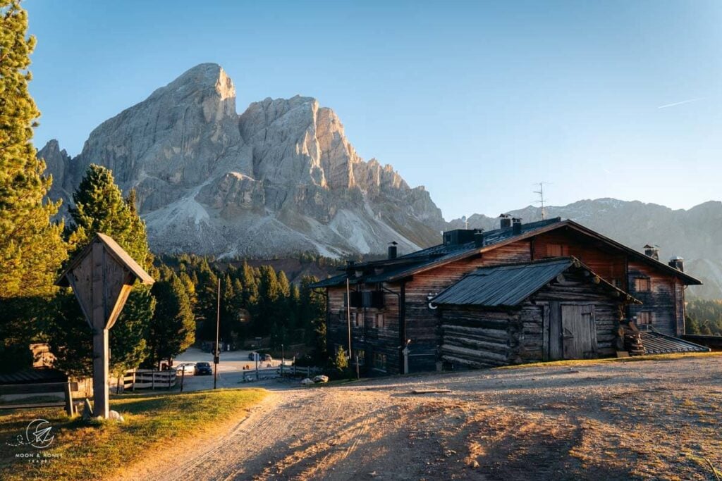
Ütia de Börz (2006 m) stands directly on Passo delle Erbe. With unobstructed views of Sass de Putia, this amazing guesthouse is the best place to stay for this hike.
We LOVED everything about our stay here. The location is outstanding, allowing you to experience sunrise and sunset, without an extra effort.
Furthermore, the quality of the food is extraordinary. Their 4-course dinner menu introduces you to the flavors and ingredients of the region. The portions are generous and the plating is captivating. And, they have an excellent wine list, featuring Alto Adige wine by the glass and the bottle.
Look for accommodation near Passo delle Erbe.
Val di Funes
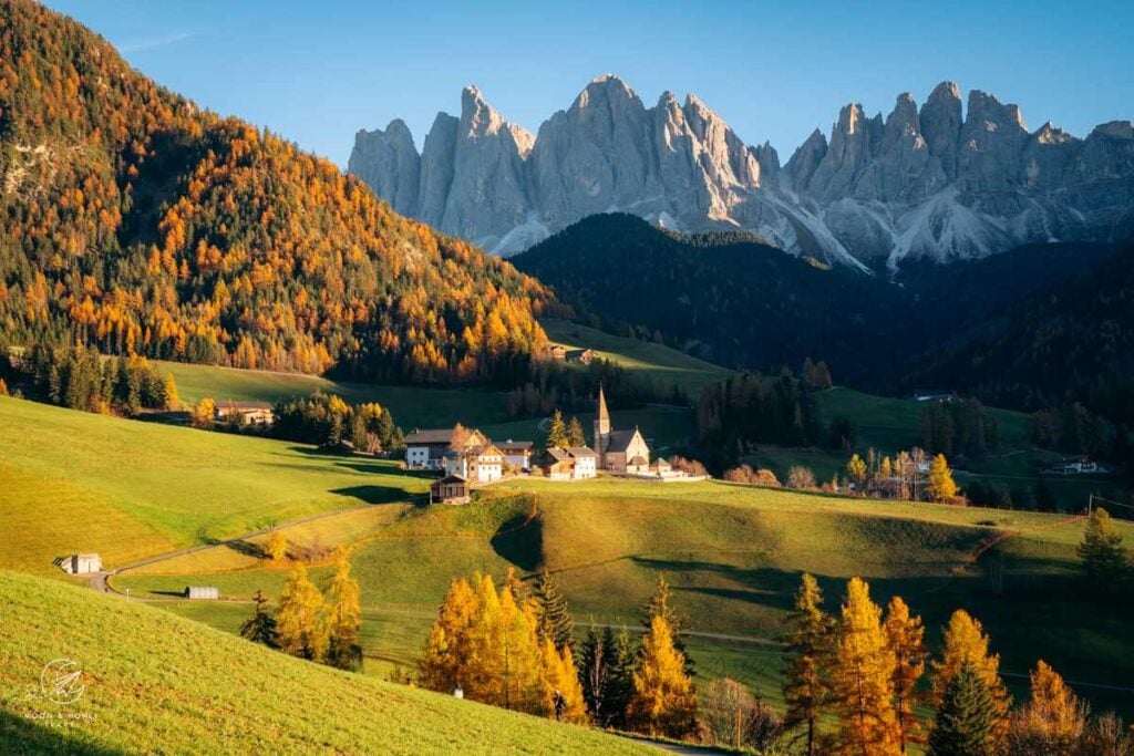
Budget | Appartements Pension Sonia is a no-frills, budget-friendly guesthouse in Santa Maddalena. Breakfast is included in the room rate.
Budget | Fallerhof is an active farm and a great-value apartment-style accommodation with stunning views of the Geisler Group. It’s a short walk to the Santa Maddalena Church (5 minutes) and the famous Chiesetta di San Giovanni in Ranui (15 minutes). Breakfast is available upon request.
Midrange | Hotel Fines is a welcoming, 3-star hotel in Santa Maddalena, owned by a young and enthusiastic team. Guests love the rich breakfast buffet, central location, and hotel restaurant. Definitely book half board (breakfast and dinner) here.
Midrange | Proihof is a happily-situated farm stay in Santa Maddalena offering charming alpine rooms and apartments as well as stellar views of the Odle/Geisler Group. Stay here for the dreaming surroundings, farm animals, and down-to-earth atmosphere.
Look for accommodation in Santa Maddalena.
More Dolomites Hiking Guides
Val di Funes Hiking Trails:
Val Badia Hiking Trails:
- Alta Badia Summer Guide
- Rifugio Puez Day Hike
- Lake Pisciadù Day Hike
- Rifugio Fanes Day Hike
- Armentara Meadows Day Hike
Dolomites Guides:
- Where to Stay in the Dolomites in Summer
- Best Time to Visit the Dolomites
- How to Get to the Dolomites
- How to Visit the Dolomites Without a Car
Dolomites Itineraries:


Pin this Image for Future Trip Planning!
Stay Connected:
Connect with us on Pinterest.
Follow us on Instagram.
Like us on Facebook.
Support Us:
If you love reading our content, you can say thank you via Ko-Fi.