This unforgettable Val Venegia-Rifugio Mulaz circuit hike in the Pale di San Martino Dolomites is like a perfectly composed multi-course meal bursting with flavor, color, and texture.
It begins with an amuse-bouche that delights the senses: arriving at the Malga Venegia trailhead. Next comes the aperitif, stimulating your appetite as you stroll through the idyllic Val Venegia. Then an hors d’oeuvre that pleases the eyes: the Malga Venegiota alpine pasture. As for the main course and dessert, you’ll have to read on to discover them.
We loved this particular Dolomites day hike, because of how it unfolds. It’s never boring, and the rewards are many. Just when we thought it couldn’t get any better, it surprised us again and again.

- Trailhead: Parcheggio Malga Venegia in Val Venegia, Trentino | Google Maps
- Distance: 12.6 km lollipop-circuit
- Time Needed: 6:30 – 7 hours
- Elevation Gain/Loss: 1054 meters
- Difficulty: Moderately Difficult – Difficult
- Route: Malga Venegia parking lot (1778 m) – Malga Venegiota (1824 m) – Passo Mulaz (2619 m) – Rifugio Mulaz (2571 m) – Sasso Arduini (2582 m) – Passo dei Fochet (2291 m) – Passo di Venegiota (2299 m) – Malga Venegiota (1824 m) – Malga Venegia parking lot (1778 m)
- Where to Stay: Residence Taufer (budget), Hotel Vienna (midrange), or Sayonara Nature & Wellness Hotel (luxury) in San Martino di Castrozza
- Recommended Trail Map: Tabacco 022 Pale di San Martino
Val Venegia to Rifugio Mulaz Hiking Map
How to Get to Val Venegia

Val Venegia lies between Passo Rolle and Passo Valles in Trentino, with the closest towns being San Martino di Castrozza, Pie’ Falcade, and Predazzo.
From San Martino di Castrozza, the drive to Val Venegia takes around 34 minutes (19.6 km). Follow the SS50 north toward Passo Rolle. At the junction with SP81, make a sharp right toward Passo Valles (signposted Falcade/Belluno), then turn right into Val Venegia.
From Predazzo, the drive takes about 30 minutes (18.7 km). Head east on the SS50 toward Passo Rolle, then turn left onto SP81 in the direction of Passo Valles (signposted Falcade/Belluno). From there, turn right into Val Venegia.
Parking in Val Venegia
Restrictions | Car camping and wild camping are strictly prohibited in Val Venegia and throughout the Paneveggio–Pale di San Martino Natural Park. For this reason, overnight parking in Val Venegia is not allowed between 9 pm and 7 am. This means you can park in Val Venegia starting from 7 am.
Car Parks | There are two main paid parking areas in Val Venegia: Parcheggio Pian dei Casoni (lower car park – Google Maps) and Parcheggio Malga Venegia (upper car park – Google Maps). For this hike, we recommend parking at Parcheggio Malga Venegia, which is located further inside the valley.
Parking Fees | Parcheggio Pian dei Casoni costs 7 EUR per day while Parcheggio Malga Venegia costs 10 EUR per day. The parking machines accept payment by card or with euro coins.
Park at the Upper Car Park | Shortly after entering the valley, you’ll reach the paid Pian dei Casoni car park. Continue driving the additional 1.2 km to Parcheggio Malga Venegia. Due to limited parking, it’s best to get an early start. If the road to the upper car park is closed, you can park at Pian dei Casoni car park and proceed either on foot, or by shuttle bus to Malga Venegia.
Essential Trail Info

Hiking Season | Late June until early October, depending on snow conditions. Rifugio Mulaz is open from mid-June until late-September.
Trail Direction | We hiked the circuit counterclockwise, but I think it’s easier to do it clockwise. That way, you tackle the more technical sections on the ascent and reach Rifugio Mulaz at an ideal time for lunch.
Difficulty | Moderately Difficult – Difficult
Where to Eat | Rifugio Mulaz or Malga Venegiota di Tonadico
Val Venegia to Rifugio Mulaz Trail Description
Val Venegia to Malga Venegiota (30 minutes)
From the parking lot at the Malga Venegia alpine pasture, follow the gravel road through Val Venegia to Malga Venegiota.
The gravel road crosses alpine pastures, where free-roaming cattle graze in summer. For safety reasons, it’s important to maintain a safe distance and avoid disturbing these animals.
The valley track leads you toward the northern chain of the Pala Group, which rises majestically above the valley. Along the way, you’ll follow the Torrento Travignolo stream and pass through a serene pine forest.
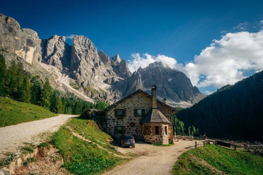
The Malga Venegiota alpine pasture hut is a destination in its own right. Calling its setting “perfect” would be an understatement. We stopped here for a coffee and a slice of cake before continuing on.
Malga Venegiota to Passo Mulaz and Rifugio Mulaz (1:40 – 2 hours)

From Malga Venegiota, continue walking along the gravel road for about 10 minutes. At the trail junction, turn left onto trail 710 in the direction of Rifugio Mulaz (signed 2 hours). Shortly thereafter, turn right to stay on trail 710.
The trail gently ascends through the forest. Beyond the forest line, the trail ascends in switchbacks, steadily gaining elevation. There are some steel cables along this path.

If you hike in the morning, the ascent to Passo Mulaz feels quite manageable, as the trail remains mostly shaded.
As you near Passo Mulaz, the trail turns to scree and becomes steeper and steeper. Don’t forget to look behind you, as the morning light engulfs the valley and illuminates the Pala peaks.

At Passo Mulaz, it’s a 10 minute descent to Rifugio Mulaz along trail 751. Eat lunch here.
Optional: Monte Mulaz Summit (1:30 out-and-back)

Many hikers continue beyond Passo Mulaz to conquer the summit of Monte Mulaz, standing at 2,906 meters.
We skipped it, exhausted from our hike to Cima della Vezzana. On another day, though, it’s something we would have definitely tackled.
Rifugio Mulaz – Passo dei Fochet – Passo di Venegiota (2:30 hours)

Follow trail 751 in the direction of Sasso Arduini peak (2582). Soon after leaving Rifugio Mulaz, the trail divides. Take the upper left track, and follow signs to Passo Valles.
Before reaching the summit of Sasso Arduini (which is a detour), trail 751 veers left and leads downhill. It’s easy to miss, if you’re fixated on heading to the summit.
The descent is initially a bit tricky. The path requires careful footing as you negotiate some rocky hairpins. A few rusty steel cables assist you in navigating a slippery section. We wore our black diamond climbing gloves for this secured stretch of trail.


After about an hour, the trail nears a tarn that makes for a great afternoon resting spot.

From here, you’ll descend through a gully along a secured path.
The trail levels out for a while, before dipping, and then diagonally ascending a rocky slope to Passo dei Fochet (2291 m).

From the pass, bear left and follow the balcony trail to a saddle, which serves as a gateway to the northern slopes of the Pala peaks.

Descend 5 minutes to Passo di Venegiota (5 minutes). At the pass, the trail sign indicates 45 minutes to Malga Venegiota.
Passo di Venegiota to Malga Venegiota (1 hour)

The trail descends gently across tussock slopes, peppered with boulders and the occasional stone pine or larch tree. It’s easy walking from here on out.
With delicious views of the Pala mountains, this sublime stretch of trail feels like the ultimate dessert. Shockingly, there was no one hiking this path.
As you continue, pay heed to the timber pole trail markers. At one point, the trail splits and it’s easy to lose sight of your way, because of the poor waymarking. Make sure to follow the poles and stay left.

Eventually, the trail reaches the forest line. Bear left on trail 749, following signs to Val Venegia. Continue descending through the pine and larch forest until reaching the valley floor.
When you reach the gravel road, turn right and walk the familiar track back to Malga Venegiota.
When we arrived at Malga Venegiota in the late afternoon, they had already stopped serving warm food.

Luckily, they were still serving homemade yogurt with berries as well as beverages. We highly recommend their yogurt. Taking a break at this hut post-hike is almost compulsory.
Malga Venegiota to Malga Venegia (30 minutes)

Follow the gravel road back to the parking lot at Malga Venegia.
Where to Stay in San Martino di Castrozza
The best base for this hike and many others in Pale di San Martino is San Martino di Castrozza. This alpine resort town is a 34-minute drive to Val Venegia. Based in San Martino di Castrozza, you’re well-positioned to hike to Baita Segantini for sunset and ascend to the central plateau of the Pala Group to tackle the Pala di San Martino Circuit Hike (Rifugio Rosetta to Rifugio Pradidali).
Budget | Residence Taufer is an affordable apartment-style accommodation, located 1 km from the center of San Martino di Castrozza. Apartments are clean and fully equipped, with all necessary appliances to make your stay here comfortable. The check-in/check-out is easy and uncomplicated. There’s a welcoming bar downstairs, where you can order espresso, drinks, and snacks throughout the day. And, the views of the Pala Group are sublime!
Midrange | Hotel Vienna is a welcoming family-run hotel, set in the heart of San Martino di Castrozza. This 3-star hotel delivers gorgeous mountain views, cozy and spacious rooms, and a great breakfast. The staff is very friendly and helpful.
Luxury | Sayonara Nature & Wellness Hotel is a top-rated luxury hotel in San Martino di Castrozza. Stay here for the spacious, alpine-modern rooms, the rich and varied breakfast buffet, and the 1000 m2 spa and wellness area. The hotel is a 5-minute walk to the center of town. The hotel’s on-site restaurant is open daily for dinner.
Look for accommodation in San Martino di Castrozza.
More Dolomites Travel Guides
Dolomites Itineraries to Pale di San Martino:
Plan your trip to the Dolomites:
- Dolomites Travel Guide
- Places to Visit in the Dolomites
- Things to Do in the Dolomites
- How to Get to the Dolomites
- How to Visit the Dolomites Without a Car
- Best Time to Visit the Dolomites
Where to Stay:
- Best Hotels in the Dolomites
- Where to Stay in the Dolomites in Summer
- Where to Stay in Cortina d’Ampezzo


Pin this Image for Future Trip Planning!
Stay Connected:
Connect with us on Pinterest.
Follow us on Instagram.
Support Us:
If you love reading our content, send me a direct donation.


Hello,
thank you for your articles! Your blog is a big helper for almost every hike we do.
I would like to ask you regarding this hike and specifically trail 751 (as you say The descent is initially a bit tricky. The path requires careful footing as you negotiate some rocky hairpins. There are some rusty steel cables that help you manage a slippery/watery section. We were happy to have our black diamond climbing gloves with us). Is it possible to hike there for with a big dog that we are not able to carry in hands.
Thank you very much in advance,
Katerina
Hi Katerina,
You’re very welcome.
A dog should be ok, but I can’t say for sure. Please reach out to the tourist office in San Martino for their expert opinion.
Sorry I can’t be more helpful,
Sabrina
4 of us just completed this hike on the 22nd June 2023. It’s a great hike, unquestionably! There was, unfortunately, still too much snow on Trail 751, and with high temperatures everyone was told by the staff at Rifugio Mulaz to avoid that route down and go back the same way.
Just to add for the website owner Sabrina – the trail is 710, NOT 720 (trail 720 does not exist!). But it’s well sign-posted at the start so it’s pretty obvious.
As a side note, this is a fantastic website with some brilliant recommendations and suggestions for hikes – thank you!
Hi Marco,
Thanks for reaching out! The trail number has been fixed.
All the best,
Sabrina
Just to note that it’s trail 710, not 720 – there is no trail 720!
Hi Marco,
Thank you for catching that. I just double-checked and you’re absolutely right!
– Sabrina