Not long ago, someone asked me: “If you could hike in only one region in Austria for the rest of your life, which would it be?” I didn’t hesitate to answer: “Tyrol (Tirol).” With its varied mountain landscapes and impeccably marked trails, Tyrol offers limitless adventures for avid hikers.
To date, the most noteworthy hiking areas I’ve visited in Tyrol are Karwendel Nature Park, Hohe Tauern National Park in East Tyrol, the Lechtal Alps, the Wetterstein Mountains, Wilder Kaiser, and the Zillertal Alps.
Below, I’ve summarized my favorite day hikes in Tyrol, each linked to a detailed trail guide with clear descriptions, difficulty ratings, trailhead details, and more. If you’re traveling with kids, also check out the family-friendly Sunnenseit’n Weg in Stubai Valley and Stone Pine Trail near Innsbruck.
For hut-to-hut hiking trail inspiration, check out my guides to the Emperor’s Crown (Kaiserkrone) Trek (moderate), Karwendel High Trail (difficult), Venediger High Trail (difficult), Berlin High Trail (difficult), and Eagle Walk Lechtal Alps (challenging).
- When to Hike in Tyrol: June – September (October depending on weather and snow conditions)
- Car-Free Travel: Hiking in Austria Without a Car
- Hiking-Themed Road Trips in Tyrol: Bavaria – Tyrol Road Trip, Munich to Dolomites Road Trip, and 2-Week Austria Road Trip
- Where to Stay in Tyrol for Hiking: Lake Achensee, Mayrhofen, Innsbruck, Stubai Valley, Ehrwald, Kals am Grossglockner
- Trail Stats: All “time needed” estimates reflect hiking time only. Plan additional time for breaks and photography.
- Toll Roads: Several trailheads in Tyrol are accessed by toll roads. Be sure to carry cash, as card payments aren’t always an option.
Tirol Hiking Map
On a map of Austrian Tyrol (Tirol), you’ll notice East Tyrol is detached from North Tyrol. This separation dates back to the end of World War I, when Italy annexed South Tyrol (Südtirol), splitting historic Tirol. This Tyrol hiking guide focuses exclusively on hikes in Austrian Tirol, not the historic region of Tirol. If you’re planning to explore South Tyrol, I recommend checking out my Italian Alps hiking guide.
Trails
Day Hikes
Hut-to-Hut Hikes
Historic Tirol Regions
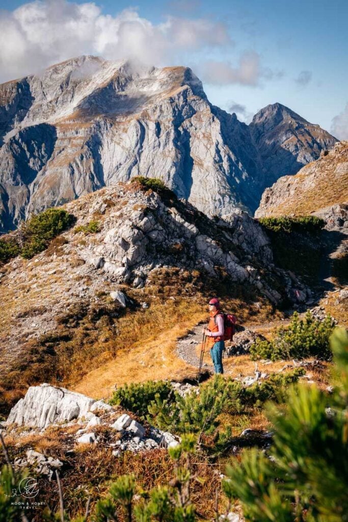
1. Seekarspitze – Seebergspitze Ridge Hike
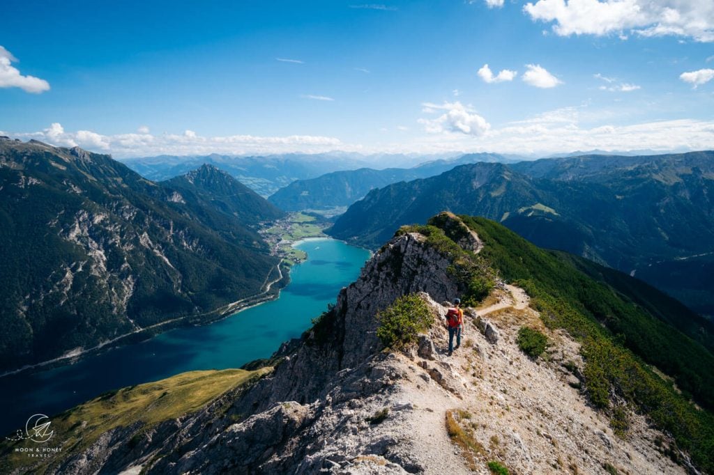
This exceptional point-to-point hike crosses the western flank of Lake Achensee, the largest lake in Tyrol. After a steep climb to Seekarspitze peak, the trail continues along a breathtaking ridge to Seebergspitze peak, all while drinking in the dazzling turquoise panorama of Achensee below.
This is a difficult hike with significant elevation gain. An easier alternative is the hike to Bärenkopf Summit, the only peak that affords a view of the entire lake.
Starting Point | Achenkirch (Bus Stop: Achenkirch Abzw Achensee)
Ending Point | Pertisau (Bus Stop: Pertisau Bootshaus)
Distance | 12.4 km point-to point
Time Needed | 6:30 hours (without breaks)
Elevation Gain/ Loss | 1300 meters
Difficulty | Difficult
Where to Stay in Pertisau | Seehotel St. Hubertus (midrange), Hotel Bergland (midrange), Hotel Auszeit (adults-only luxury), Seehotel Einwaller (adults-only luxury), or NOVA Moments Boutique Hotel (luxury)
Trail Guide: Seekarspitze – Seebergspitze Ridge Hike
2. Hahnkampel Circuit Trail

Another rewarding hike in the Lake Achensee area is the Hahnkampel Circuit Trail, which starts at Gramaialm at the end of Falzturntal Valley toll road. The path rises to the head of the valley and further up to Lamsenjochhütte, a particularly scenic hut along the Adlerweg long-distance trail. After a short detour to the refuge, the trail traces an airy, semi-secured ridge to the summit of Hahnkampel.
The bird’s-eye views of Grosser Ahornboden, the “Great Maple Floor” in Hinterrisstal, are breathtaking.
Good to Know | There is no bus to Gramaialm. If you’re traveling without a car, I would take a taxi from Pertisau to the trailhead, hike the circuit, and then walk all the way back to Pertisau following the pleasant Falzturntal valley trail (2 hours one-way).
Trailhead | Gramai Alm, Pertisau
Distance | 11.1 km circuit
Time Needed | 4:45 hours
Elevation Gain/Loss | 869 meters
Difficulty | Moderately Difficult
Where to Stay at the Trailhead | Gramai Alm Alpengenuss & Natur Spa (luxury)
Where to Stay in Pertisau | Seehotel St. Hubertus (midrange), Hotel Bergland (midrange), Seehotel Einwaller (adults-only luxury), or NOVA Moments Boutique Hotel (luxury)
Trail Guide: Gramaialm – Hahnkampel Hike
3. Hochiss Summit Hike
On the other side of Lake Achensee rise the Rofan Mountains, a subrange of the Brandenberg Alps. A well-rounded and satisfying hike leads from Erfurter Hütte, accessible by cable car from Maurach, to Hochiss summit (2299 m) and then down to Dalfaz Alm. You can return via the cable car or descend on foot through the forest.
Trailhead | Rofan Seilbahn Mountain Station, Maurach
Distance | 9.8 km circuit with cableway
Time Needed | 4:15 hours
Elevation Gain | 480 meters
Elevation Loss | 1334 meters
Difficulty | Moderately Difficult
Where to Stay in Maurach | Hotel-Café-Restaurant Klingler (budget-midrange), Hotel-Pension Huber-Hochland (midrange), or Hotel St.Georg zum See (luxury)
Trail Guide: Hochiss Peak Hike
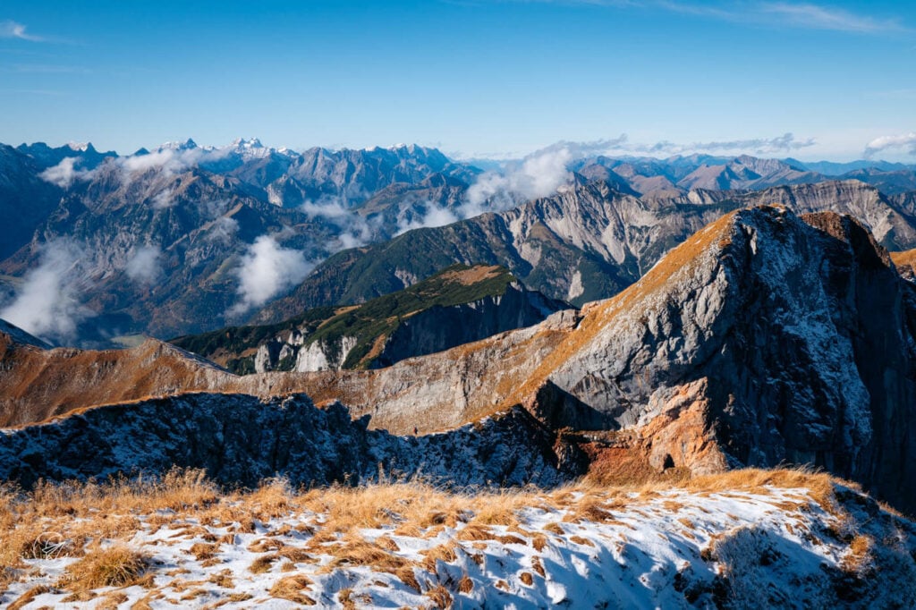
4. Gamsjoch Peak Hike

Serving up the most delicious and grandiose views of the northern Hinterautal-Vomper-Kette, the western Gramsjoch summit is one of the most rewarding day hikes in Karwendel Nature Park. The hike starts at the Eng alpine pasture in Grosser Ahornboden. Given the remote location of the trailhead, it’s advisable to stay at the trailhead in Das Naturhotel die Eng, before commencing this strenuous hike.
I also recommend hiking to the summit via the Hochljoch saddle. Though longer, it’s much easier than tackling the direct Gumpenkar gully ascent route.
Trailhead | Parking Ahornboden
Distance | 13.8 km lollipop-circuit
Time Needed | 5:45 hours
Elevation Gain/Loss | 1324 m
Difficulty | Difficult
Where to Stay at the Trailhead | Das Naturhotel die Eng
Trail Guide: Gramsjoch Peak Hike
5. Wolfsklamm Gorge Hike

Wolfsklamm (Wolf’s Gorge) is a stunning limestone river gorge in Austria’s Karwendel Mountains, considered Tyrol’s most beautiful. The well-secured but sometimes steep trail starts in Stans and leads one-way through the gorge. Hikers can continue to the nearby Benedictine monastery of St. Georgenberg, which has a restaurant.
There is a small fee to access the gorge, which is only open between May and October (9 am – 4 pm).
Trailhead | Stans Wolfsklamm Parking or Stans b.Schwaz Bahnhst train station
Distance | 5.4 km circuit
Time Needed | 2:15 hours
Elevation Gain/Loss | 410 meters
Difficulty | Moderate
Where to Stay in Stans: | Der Brandstetterhof (adults-only luxury), Das Urgestein – Apartments (luxury apartments), or Hotel Schwarzbrunn (All-inclusive luxury)
Where to Stay in Innsbruck | Motel One Innsbruck (budget-midrange), NALA individuellhotel (midrange), Altstadthotel Weisses Kreuz (luxury). Check out our guide to Where to Stay in Innsbruck for a detailed look at the best areas to stay beyond the city center.
Trail Guide: Wolfsklamm Gorge Hike
6. Nockspitze (Saile) Peak Hike

Nockspitze (2403 m) is a scenic summit hike near Innsbruck in Tyrol’s Kalkkögel range, part of the Stubai Alps. The 4-hour route crosses several peaks, offering sweeping views of the Inn Valley, Innsbruck, the Karwendel Mountains, and the Stubai Alps. While mostly moderate, the hike includes some steep, slippery sections which require surefootedness.
Trailhead | Birgitzköpfl Chairlift Mountain Station / Axamer Lizum
Distance | 6.4 km circuit with chairlift ascent
Time Needed | 4 hours
Elevation Gain | 418 meters
Elevation Loss | 905 meters
Difficulty | Moderate – Moderately-Difficult
Where to Stay in/around Axams | Pension Singer (budget), Ferienwohnung Olympia (budget), Hotel Kögele (midrange) Die Wiesen Apartments (midrange)
Trail Guide: Nockspitze Peak Hike
7. Rotmoosalm – Wangalm – Wettersteinhütte Circuit Trail

This day hike in the Wetterstein Mountains captures the essence of hiking in the Austrian Alps: towering limestone walls, inviting mountain huts, and diverse trails. It begins at the Salzbachbrücke paid car park in Gaistal Valley near Seefeld in Tirol.
The highlight of the route is the Südwandsteig trail, which runs along the foot of Wetterstein massif’s south wall. This range marks part of the border between Tyrol and Bavaria. Cross it, and you’ll end up near Garmisch-Partenkirchen.
Trailhead | Salzbach Car Park in Gaistal (P5), Leutasch
Distance | 17.6 km lollipop-circuit
Time Needed | 6:30 hours
Elevation Gain/Loss | 910 meters
Difficulty | Moderate
Where to Stay in Seefeld in Tirol | Hotel Residence Metropol (budget), Apart Simon Seefeld (budget), Tiroler Weinstube (midrange), Summit Seefeld (midrange-luxury), or Hotel Klosterbräu (luxury)
Where to Stay in Mösern near Seefeld in Tirol | Nidum Casual Luxury Hotel (luxury). Read our Nidum hotel review to learn more about this amazing hotel, tucked away on the edge of the Seefeld Plateau.
Trail Guide: Rotmoosalm – Wettersteinhütte Hike
8. Lake Seebensee – Lake Drachensee – Coburger Hütte Hike

Lake Seebensee and Lake Drachensee rank among the most breathtaking alpine lakes in Tyrol.
While most hikers opt for the straightforward out-and-back route from the Ehrwalder Almbahn Mountain Station, there’s a far more rewarding way to reach them: via Brendlsee and the Hinteres Tajatörl pass.
The descent from Hinteres Tajatörl down to Lake Drachensee is nothing short of spectacular, revealing shimmering turquoise waters embedded in a craggy limestone paradise.
These lakes are no secret, so timing is everything. Take the earliest cable car you can.
Trailhead | Ehrwalder Almbahn Mountain Station
Distance | 14.9 km circuit
Time Needed | 5:30 hours
Elevation Gain/Loss | 909 meters
Difficulty | Moderately Difficult
Where to Stay in Ehrwald | Mellow Mountain Hostel (budget), Das Halali (midrange), or Romantik Hotel Spielmann (luxury)
Trail Guide: Lake Drachensee Hike
9. Olpererhütte and Friesenberghaus Hike

High above the Schlegeis Reservoir, the happily situated Olpererhütte enjoys one of the best views of the Zillertal Alps. This hut has gained widespread attention on Instagram, thanks to its nearby suspension bridge photo spot.
Although most hikers make a beeline for Olpererhütte from the Schlegeis Reservoir car park, the route via Friesenberghaus offers a far richer and less crowded experience.
Starting at Frisenberghaus, the trail follows one of the most cinematic stretches of the celebrated Berlin High Trail hut-to-hut hike to the suspension bridge and further to Olpererhütte.
Trailhead | Parking Schlegeisspeicher, accessed by a toll road
Distance | 13.8 km circuit
Time Needed | 5:30 hours
Elevation Gain/Loss | 876 m
Difficulty | Moderate – Moderately Difficult
Where to Stay in Mayrhofen | Landhotel Rauchenwalderhof (budget), Der Siegeler B&B (budget-midrange), Alpenhotel Kramerwirt (midrange-luxury), or ElisabethHotel Premium Private Retreat- Adults only (luxury)
Trail Guide: Olpererhütte Hike
10. Innergschlöss Glacier Trail

The Innergschlöss Glacier Trail is a scenic 9.6 km loop in Hohe Tauern National Park that leads from Innergschlöss village, only accessible by taxi or foot from Matreier Tauernhaus, to the Schlatenkees Glacier. You’ll pass striking moraine landscapes before reaching the viewpoint of the glacier terminus.
Trailhead | Innergschlöss
Distance | 9.6 km lollipop-circuit
Time Needed | 3:30 hours
Difficulty | Moderate
Elevation Gain/Loss | 608 meters
Where to Stay near the Trailhead | Matreier Tauernhaus (budget-midrange)
Where to Stay in Matrei in Osttirol | Kesslerstadel (midrange), Hotel Hinteregger (midrange), or Naturhotel Outside (luxury)
Trail Guide: Innergschlöss Glacier Trail
More Austria Hiking Guides
More Hikes in Tyrol:
- Bärenkopf Summit Hike (moderate)
- Hundskopf Via Ferrata (difficult, via ferrata equipment needed)
Hiking:
Hut-to-Hut Hiking:
Seasonal Travel Guides:


Pin this Image for Future Trip Planning!
Stay Connected:
Connect with us on Pinterest.
Follow us on Instagram.
Support Us:
If you love reading our content, send me a direct donation.

