Rounding Pala di San Martino (2987 m) feels like an intimate journey into the Pala range, guiding you into the high-alpine heart of these majestic Pale di San Martino mountains. The circuit connects two managed mountain huts, Rifugio Rosetta and Rifugio Pradidali, with the latter being our preferred spot for lunch.
The trail begins on the edge of the Altopiano delle Pale di San Martino plateau, accessible by two cableways from San Martino di Castrozza in the Italian Dolomites.
This day hike is both thrilling and challenging, requiring confidence on secured ledges with steep drop-offs and agility across uneven karst terrain. Much of the trail feels like traversing a lunar landscape, a vast ocean of stone.
Because this hike circuits Pala di San Martino, this trail is often called Giro della Pala di San Martino, which simply means Tour of the Pala di San Martino.
- Starting Point: Colverde Gondola Valley Station in San Martino di Castrozza | Google Maps
- Trailhead: Rosetta Cableway Mountain Station
- Distance: 12.1 km circuit
- Time Needed: 6 hours
- Elevation Gain/Loss: 909 meters
- Difficulty: Difficult
- Route: Rosetta Cableway Mountain Station (2635 m) – Rifugio Rosetta (2581 m) – Passo di Val di Roda (2580 m) – Col delle Fede (2278) – Passo di Ball (2451 m) – Rifugio Pradidali (2278 m) – Passo Pradidali Basso (2658 m) – Rifugio Rosetta (2581 m) – Col Verde-Rosetta cableway mountain station (2635 m)
- Where to Eat: Rifugio Rosetta or Rifugio Pradidali
- Where to Stay: Residence Taufer (budget), Hotel Vienna (midrange), or Sayonara Nature & Wellness Hotel (luxury) in San Martino di Castrozza
- Recommended Trail Map: Tabacco 022 Pale di San Martino
Pala di San Martino Circuit Hiking Map
Hiking around Pala di San Martino: Safety and Difficulty
This hike requires good, stable weather. If conditions are poor, this loop trail can be potentially dangerous. Without proper visibility, it’s easy to get lost.
This hike also requires some alpine hiking experience. You should be confident hiking up and down scree and rocky karst terrain.
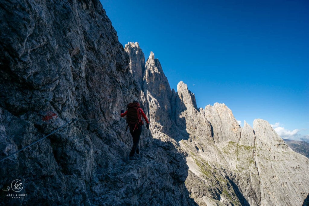
Furthermore, you should have a head for heights. There’s one lengthy secured passage, which is easily managed without equipment.
Nonetheless, we highly recommend climbing gloves, which makes grasping steel cables more comfortable. This passage could pose a real challenge to anyone afraid of heights.
Getting to the Trailhead: Colverde Gondola Valley Station
This hike requires an ascending and descending two cableways: (1) Colverde gondola and (2) the Rosetta Cable car. The Colverde Gondola valley station is located in San Martino di Castrozza. There’s a free parking lot at the valley station.
Check current pricing for the Colverde and Rosetta return combi-ticket.
Location | San Martino di Castrozza
Open | June 14 to September 28, 2025
Colverde Gondola Operating Times | 8:15 am – 4:50 pm
Rosetta Cable Car Operating Times | 8:30 am – 4:40 pm. The cable car does not operate between 1 pm to 1:40 pm.
Which Direction to Hike around Pala di San Martino
From Rifugio Rosetta, you can either hike to Rifugio Pradidali via Passo di Ball (recommended), or via Passo Pradidali Basso.
The latter is more popular, but we think it’s better to hike counter-clockwise. By hiking to Passo di Ball first, you’ll ascend a long secured section, which is significantly easier than descending.
Also, the trail from Rifugio Pradidali to Passo Pradidali Basso has some difficult passages across crumbling scree terrain, which is safer to ascend.
When can you hike around Pala di San Martino
Late June until mid-October, weather permitting.
If you’re hiking here between late September and mid-October, the cableways are only open on the weekend.
We recommend hiking this trail in early-mid September when the weather is generally stable and there are fewer visitors.
Rifugio Rosetta and Rifugio Pradidali Circuit Trail Description
Rosetta Cableway Mountain Station to Rifugio Rosetta (15 minutes)
Upon exiting the Rosetta mountain station, Rifugio Rosetta is immediately visible.
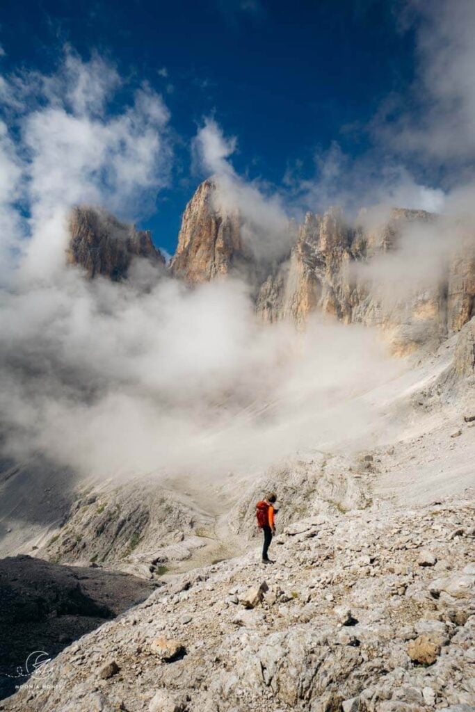
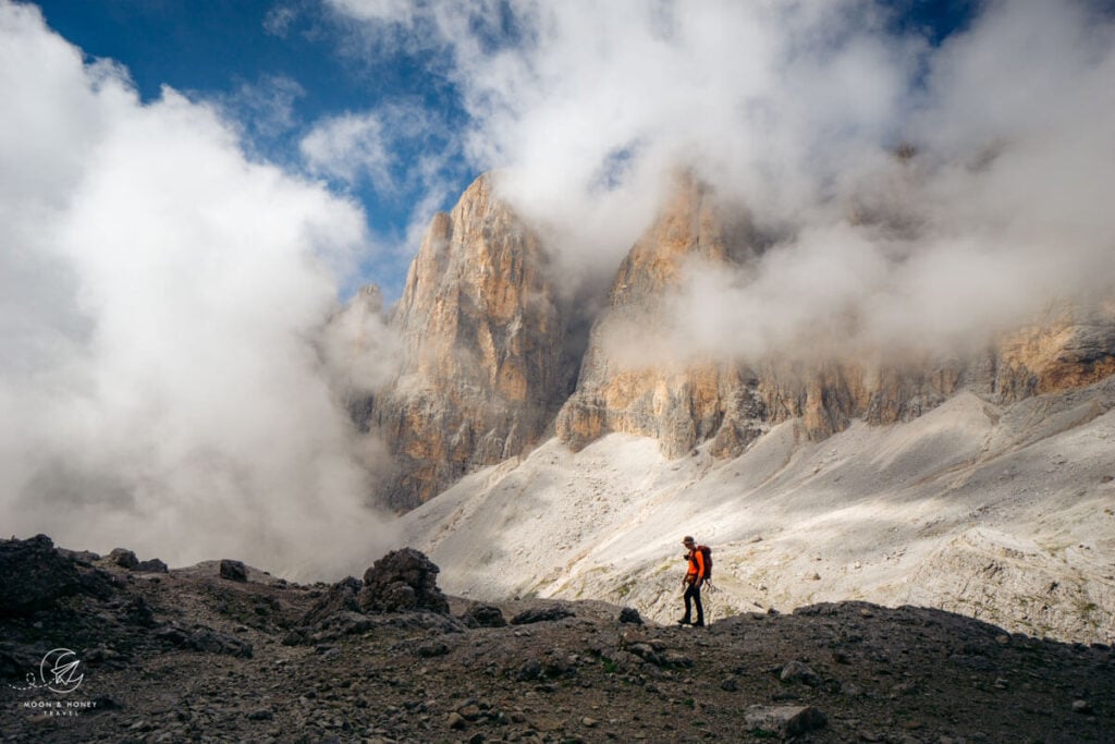
The three-story mountain hut with blue and white shutters is located on the Altopiano Pale di San Martino plateau, which looks like a sea of bleached stone.
Rifugio Rosetta to Passo di Ball (1:45 – 2 hours)

The circuit trail around Pala di San Martino begins at Rifugio Rosetta.
From the hut, locate trail 702 to Rifuguio Pradidali, signed 2 hours. After about 10 minutes, you’ll reach Passo Val di Roda (2560 m). Shortly thereafter, the trail descends sinuously along switchbacks. Though this part is a bit monotonous, it’s not difficult.
When the trail levels, the mountains captivate with their unique shapes and pale hues. Skirting the base of Croda di Roda, continue south.
The grassy plateau of Col delle Fede (2278 m) invites you to take a break, and marvel at the scenery before you. Straight ahead, you’ll see a dramatic mule track zigzagging its way up from Val di Roda to the plateau.

Continue following this level, linear path – now trail 715.
Soon, you’ll encounter the first steel cable. With the help of fixed cables, you’ll ascend to Passo di Ball along narrow passages. This is a rather long secured passage, but it’s not overly difficult (for experienced hikers), and it makes the hike far more interesting.

Some light scrambling might be needed. You’ll arrive at the grass-carpeted Passo di Ball before you know it.
Read Next: Best Day Hikes in the Dolomites
Passo di Ball to Rifugio Pradidali (25 minutes)

Passo di Ball is the mountain pass between Cima di Ball and Cima Pradidali.
From Passo di Ball, trail 715 descends to Rifugio Pradidali. This is a lovely trail that meanders through boulders, before dropping down to the Pradidali Hut.

Behind the hut, the towering Cima Canali pierces the clouds.
Rifugio Pradidali to Passo Pradidali Basso (1:15 hours)

From Rifugio Pradidali, follow trail 709 in the direction of Lago Pradidali lake. The trail ascends the upper Val Pradidali valley all the way to the central plateau of Pale di San Martino.
After passing the small lake, the trail steadily climbs up the valley, which is flanked by Cima Pradidali and Cima Immink on the left-side (west) and Cima Canali and Cima Wilma on the right (east).

You’ll ascend from one terrace to another. Some scrambling is needed.
When you reach an intersection (~45 minutes after leaving the hut), turn left to stay on trail 709.
Continue hiking up another 25 minutes to reach Passo Pradidali Basso (2658 m).
Passo Pradidali Basso to Rifugio Rosetta (1 hour)

Passo Pradidali acts like an entryway to the vast, lunar landscape of Altopiano Pale di San Martino. As far as the eye can see, bleached white stone extends in every direction.
Follow the painted waymarks across the rolling rockscapes all the way to Rifugio Rosetta.
Initially, you’ll cut across a rock wall, before tackling the long undulating stone sea. Attention is needed because this isn’t a flat, easy-going finale. It’s up and down and requires careful footing.
When trail 709 ends, join trail 707, bearing left.
Rifugio Rosetta to Rosetta Cableway Mountain Station (15 minutes)
To complete the circuit, hike back to the Rosetta mountain station.
Where to Stay in San Martino di Castrozza

The best base for this hike and many others in Pale di San Martino is San Martino di Castrozza. The Colverde gondola valley station is located directly in town.
From San Martino di Castrozza, you’re well-positioned to hike to Baita Segantini for sunset, ascend to the central plateau of the Pala Group to tackle the summit of Cima della Vezzana, and visit Val Venegia to hike to Rifugio Mulaz.
Budget | Residence Taufer is an affordable apartment-style accommodation, located 1 km from the center of San Martino di Castrozza. Apartments are clean and fully equipped, with all necessary appliances to make your stay here comfortable. The check-in/check-out is easy and uncomplicated. There’s a welcoming bar downstairs, where you can order espresso, drinks, and snacks throughout the day. And, the views of the Pala Group are sublime!
Midrange | Hotel Vienna is a welcoming family-run hotel, set in the heart of San Martino di Castrozza. This 3-star hotel delivers gorgeous mountain views, cozy and spacious rooms, and a great breakfast. The staff is very friendly and helpful.
Luxury | Sayonara Nature & Wellness Hotel is a top-rated luxury hotel in San Martino di Castrozza. Stay here for the spacious, alpine-modern rooms, the rich and varied breakfast buffet, and the 1000 m2 spa and wellness area. The hotel is a 5-minute walk to the center of town. The hotel’s on-site restaurant is open daily for dinner.
Look for accommodation in San Martino di Castrozza.
More Dolomites Guides
Plan your trip to the Dolomites:
- Dolomites Travel Guide
- Where to Stay in the Dolomites in Summer
- Places to Visit in the Dolomites
- Things to Do in the Dolomites
- How to Get to the Dolomites
- Best Time to Visit the Dolomites
- Day Hikes in the Dolomites
Road Trip Itineraries:
- 5-Day Dolomites Road Trip
- 7-Day Dolomites Road Trip
- 10-14 Day Dolomites Road Trip
- Munich to Dolomites Road Trip
Car-Free Travel:


Pin this Image for Future Trip Planning!
Stay Connected:
Connect with us on Pinterest.
Follow us on Instagram.
Support Us:
If you love reading our content, send me a direct donation.

