Hohes Rad (“High Wheel”) is a mountain in the Silvretta Alps in Austria. The peak straddles the border between Tirol and Vorarlberg.
A wonderful hiking trail wraps around Hohes Rad (2934 m), starting at Silvretta Bielerhöhe (2037 m), a high mountain pass connecting Montafon Valley in Vorarlberg with Paznaun Valley in Tirol.
The pass lies on the Silvretta Hochalpenstrasse (Silvrettta High Alpine Road), between the Silvretta Alps and the Verwall Alps.
This is one of the best day hikes in Austria, because of the pristine environment, epic high-alpine scenery, and the glacier views (albeit retreating).
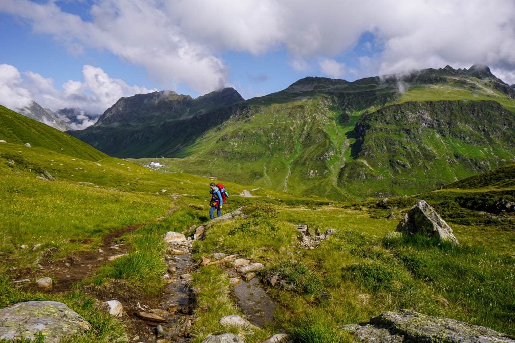
From the Silvretta Reservoir, the trail gently ascends Bieltal Valley to the Radsattel.
From the mountain saddle, you can detour to the summit of Hohes Rad (3 hours out-and-back) – a challenging peak hike best undertaken by experienced hikers.
The circuit trail continues over the Rad saddle and along the Edmund-Lorenz Weg, ultimately descending to Wiesbadener Hütte, set amidst a frozen world of ice, water, and rock.
From this impressive mountaineering hut, the trail descends the Oschental Valley back to the Silvretta Reservoir.
If you want to extend this day hike, you can follow the Montafon Hut to Hut Circuit Trail.

- Trailhead: Silvretta Bielerhöhe (2037 m) | Google Maps
- Distance: 14.8 km circuit
- Time Needed: 5 hours
- Elevation Gain/Loss: 720 meters
- Difficulty: Moderate
- Minimum Elevation: 2025 meters
- Maximum Elevation: 2658 meters
- When to Hike: When the Silvretta High Alpine Road is open. Typically, late June – late September, depending on snow conditions.
- Weather Forecast and Webcam: Bergfex Weather Bielerhöhe
- Where to Eat: Wiesbadener Hütte (cash only)
- Where to Stay: TUI Blue Montafon (budget), Gasthof Löwen (midrange), Amrai Suites (luxury) in Schruns-Tschagguns
- Recommended Trail Map: Freytag & Berndt WK374 Montafon
- Recommended Itinerary: Austria Road Trip Itinerary (2 weeks)
Hohes Rad Hiking Map
How to Get to Silvretta Bielerhöhe
Bus
Schruns (Vorarlberg) to Silvretta Bielerhöhe
Bus 650S connects Schruns Bahnhof with Silvretta Bielerhöhe. Use the VMOBIL route planner to find the best transit connections.
When we took the bus, it was cash only.
Transit Time | 1 hour 5 minutes
Paznaun (Tyrol) to Silvretta Bielerhöhe
Use the VVT Smartride journey planner to find the best transit connection.
Car
You can also drive up to Silvretta Bielerhöhe along the Silvretta High Alpine Road from either Montafon (Vorarlberg) or Paznauntal Valley (Tyrol).
Schruns, Montafon, to Silvretta Bielerhöhe | 40 minutes, 31.7 km
Galtür, Paznauntal, to Silvretta Bielerhöhe | 20 minutes, 12.1 km
Pricing toll road | Current Silvretta Hochalpenstrasse Pricing
Hohes Rad Circuit Trail Description
Silvretta Bielerhöhe to Radsattel (2:30 hours)

From the bus stop at Silvretta Bielerhöhe, head in the direction of Tirol, passing the tourist shop and the restaurant.
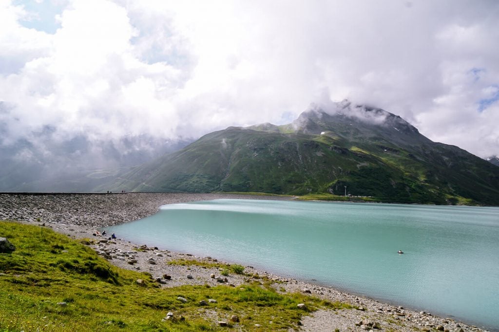
Hike along the Silvretta Staumauer (reservoir wall), hugging the milky-turquoise reservoir, and make your way to Bieltal (Biel Valley).
Follow signs to Wiesbadener Hütte. When the trail divides, follow the left trail to Wiesbadender Hütte über Bieltal (3:15 hours) and Radsattel (2:15 hours).
There are other ways to Wiesbadener Hütte, but this is the most enjoyable.
As you progress, there are spectacular views of the Verwall Alps and the serpentine Silvretta High Alpine Road (Silvretta Hochalpenstrasse).
The trail gently ascends along the Bieltalbach (Biel Valley Stream) all the way up to Radsattel (2652 m).
Accompanied by the sound of running water, you’ll follow this soft valley trail for a good 1:30 hours before it steepens.
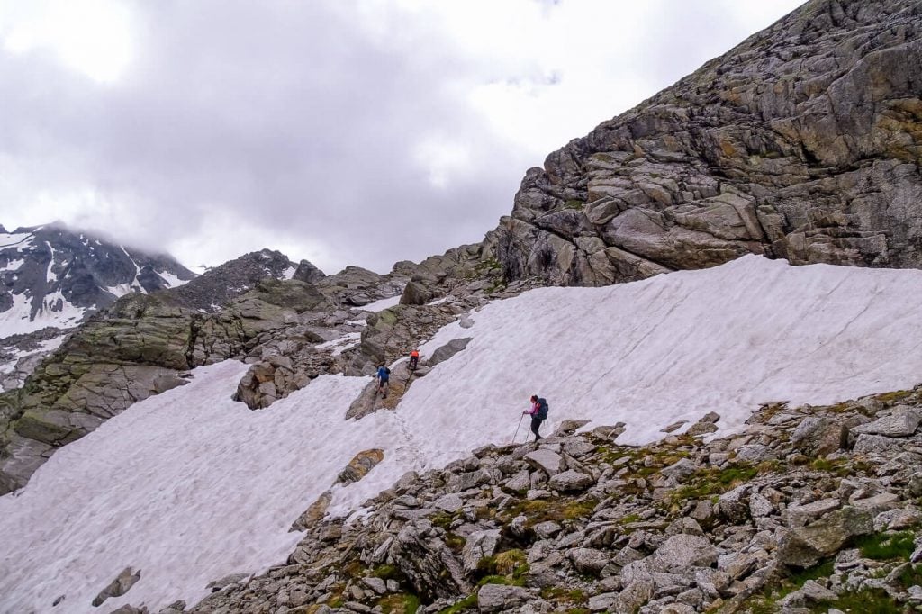
As you near the saddle, you’ll traverse some boulders and possibly a snowfield (in early summer).
There’s a small lake on your right called Radsee. Keep your eyes out for roaming Ibex. We saw at least two dozen.

The Radsattel (2652 m) is the mountain saddle between Bieltalkopf (2797 m, Biel Valley Head) and Hohes Rad (2934 m).
When you crest the saddle, you’ll be met with sweeping views of glaciated Silvretta peaks.
Optional Detour: Hohes Rad Peak

For those that want to detour to Hohes Rad peak, you can turn right at the Rad saddle and hike 30 minutes to the Radschulter (Rad Shoulder), crossing a slope of boulders.
Snow lingers along this trail into late July.
From the Radschulter (2697 m), it’s a 40-minute ascent to the peak. This trail requires scrambling, sure-footedness, and a head for heights.
There are some tricky, exposed steps as you near the summit.

The peak rewards you with panoramic views of the Oschental valley, Silvretta and Verwall mountains, and the Silvretta Stausee reservoir.

Return by the same route to the Radsattel.
Trail Stats Hohes Rad Peak Detour
Distance | 3.1 km out-and-back
Time Needed | 3 hours
Elevation Gain/Loss | 373 meters
Difficulty | Difficult
Minimum Elevation | 2618 m
Maximum Elevation | 2934 m
Radsattel to Wiesbadener Hütte (50 minutes)

From Radsattel, it’s a mere 50-minute hike to Wiesbadener Hütte.
Descend in the direction of the small pond straight ahead. Before reaching the pond, the trail splits. Follow the left trail to Wiesbadener Hütte (40 minutes).
From here, follow an undulating path, at times ascending, for the next 30 minutes.
The scenery stretches out sublimely before you, creating a visual crescendo of soaring peaks, accented by glacial ice.
It feels like you’re embarking on an epic journey with great purpose and a sense of adventure.

Ultimately, the path descends to Wiesbadener Hütte (2443 m), the impressive mountain lodge facing Piz Buin, the quickly retreating Ochsentaler and Vermunt glaciers, and the Silvrettahorn.

Wiesbadener Hütte is a managed DAV mountain hut. The hut is usually open from mid June until late September. Bring cash.
Wiesbadener Hütte is extremely popular among climbers and mountaineers, because it’s the starting point for climbs up to Piz Buin.
Wiesbadener Hütte to Silvretta Bielerhöhe (2 hours)

From the hut, descend Ochsental valley to the Silvretta Stausee. The trail is a wide gravel track, so it’s very easy walking from here on out.
When you get to Southern-tip of the Silvretta Reservoir, head right and walk along the reservoir back to the Bielerhöhe mountain pass.
Where to Stay near Silvretta Bielerhöhe
Schruns-Tschagguns, Montafon
Budget | The brand new TUI Blue Montafon hotel in Tschagguns features modern, comfortable, and quiet (sound-proof) bedrooms. Guests praise the attentiveness and friendliness of the staff. And, the breakfast buffet is excellent, offering a lot of variety and local ingredients. The hotel has an on-site restaurant (limited menu) and small spa area.
Midrange | The quaint Gasthof Löwen in Tschagguns is a traditional, family-run hotel dating back to 1500. The hotel restaurant is one of the best places to eat in Montafon. It’s also one of our favorite restaurants in all of Austria. Expect a wonderful breakfast as well. On Thursdays, the family members play traditional music in the bar. Guests also have access to the Montafoner Hof indoor-outdoor pool.
Luxury | Amrai Suites is an alpine-modern hotel in Schruns with an on-site restaurant and luxurious wellness area. Tastefully designed with natural materials and an earthy color palette, the hotel bedrooms are both calming and visually stunning. Highlights of staying here are the breakfast buffet, creative dinner menus (featuring local and fresh ingredients), and the Stólla spa oasis, which pays homage to the region’s former mining industry. It encompasses an indoor copper bath, herbal kettle sauna, Finnish sauna, steam bath, rain shower, ice fountain in the Montafon Glacier Grotto, outdoor pool, and relaxation rooms.
Look for accommodation in Schruns-Tschagguns.
More Vorarlberg + Austria Hiking Guides
Brandnertal Valley:
- Lake Lünersee
- Schesaplana Peak Hike
- Schafgafall Peak Hike
- Rätikon Alps High Trail Circuit
- Review: Hotel Lün in Brand
Lech am Arlberg:
- Lech am Arlberg Hiking Guide
- Best Hotels in Lech am Arlberg
- Lake Formarinsee to Lake Spullersee Hike
- Rüfikopf – Stuttgarter Hütte Hike
- Oberlech – Göppinger Hütte Hike
- Spuller Schafberg Peak Hike
Hiking in Austria:


