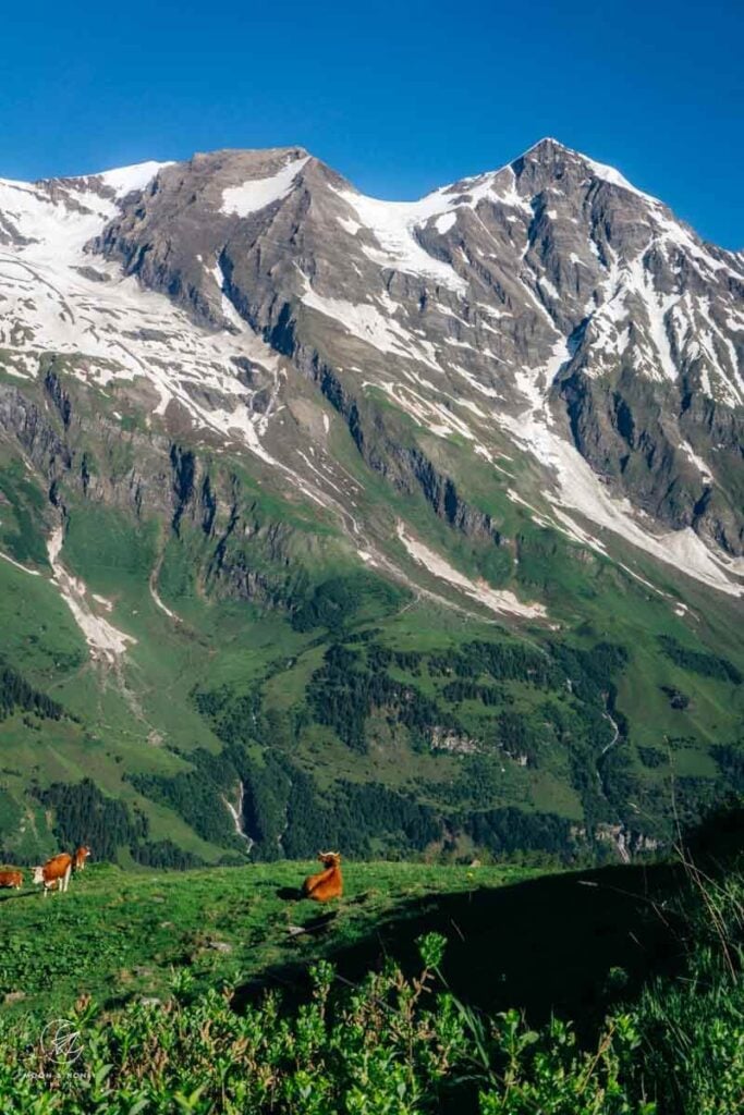
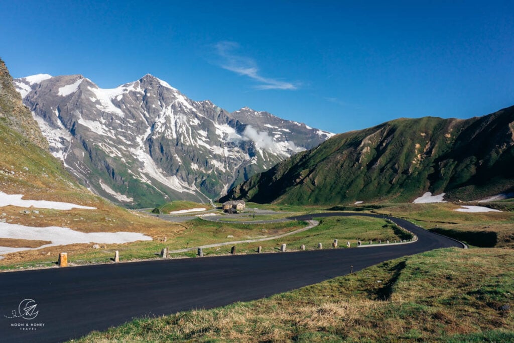
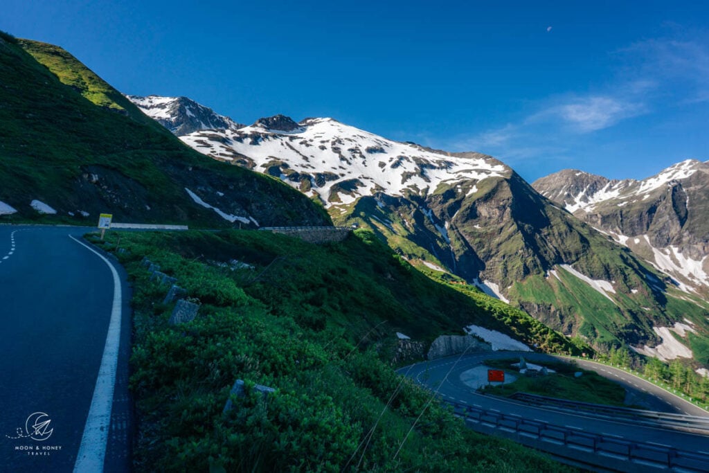
Austria’s Grossglockner High Alpine Road (Großglockner Hochalpenstraße in German) is a paved serpentine road that steers you into the heart of Hohe Tauern National Park in the Austrian Alps and directly to the base of the Grossglockner (3798 m), Austria’s highest mountain.
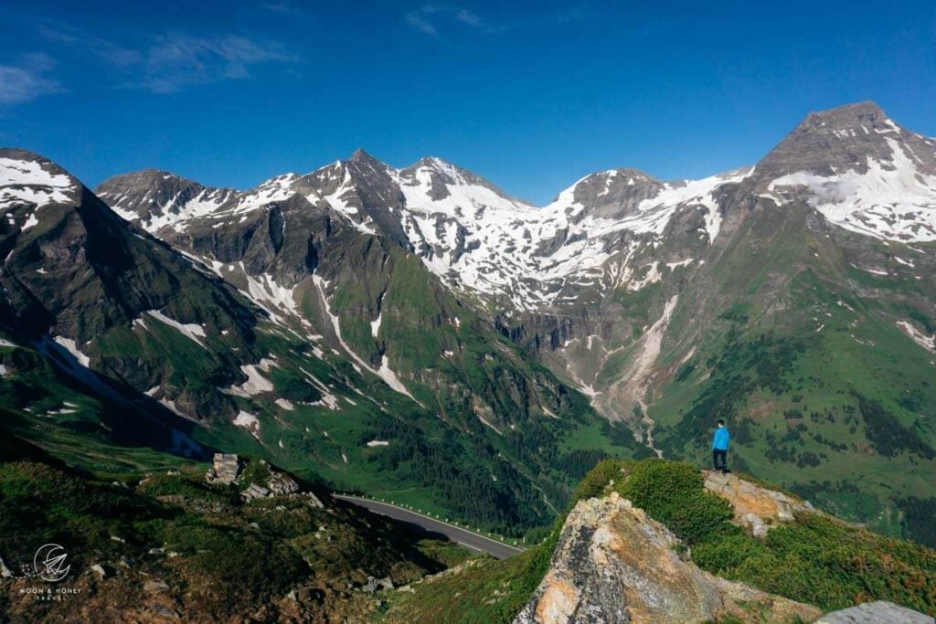
This is simply one of Europe’s finest mountain roads. Panoramic views of Austria’s highest peaks encircle you as you drive deeper into the High Tauern mountains. Along the way, viewpoints and trailheads invite you to slow down and take it all in.
Construction on this 48-km road began in 1930 and was completed five years later. Today, 900,000 people visit each year.
The Grossglockner High Alpine Road connects Fusch an der Großglocknerstraße in Salzburg with Heiligenblut am Großglockner in Carinthia. You can drive in either direction, since no particular direction is more beautiful.
Find out how to integrate the Großglockner High Alpine Road into a 14-Day Austria Road Trip or 7-Day Austria Road Trip.
- Road Length: 48 km
- Opening Times: Early-mid May until early November, weather depending.
- Weather Forecast and Webcam: Bergfex Weather Grossglockner
- North Entrance: Fusch an der Großglocknerstraße in Salzburg
- South Entrance: Heiligenblut am Großglockner in Carinthia
- Must-do hike: Glacier Trail Pasterze
- Where to Stay: Wallackhaus
- Recommended Trail Map: Großglockner WK 120
Grossglockner High Alpine Road Map
Opening Times
This scenic route through Hohe Tauern National Park is generally open from early-mid May until early November. When we visited in mid-June, the road conditions were perfect. However, because of the long winter, some hiking trails were still closed.
In season, the road is generally open from sunrise to sunset. Outside these hours, there’s an official ban on night-time driving.
Opening – May 31 | 6 am – 8 pm (Last entry at 7:15 pm)
June 1 – August 31 | 5:30 am – 9 pm (Last entry at 8:15 pm)
September 1 – Closing | 6 am – 7:30 pm (Last entry at 6:45 pm)
How Much Is the Grossglockner High Alpine Road?
In 2026, driving the Grossglockner High Alpine Road costs 46.50 EUR for private cars and 36.50 EUR for motorcycles. Reduced rates are available for electric or hydrogen vehicles.
There’s a toll station near Wildpark Ferleiten if you’re coming from Salzburg (north), and another near Heiligenblut if you’re approaching from Carinthia (south).
It’s also possible to purchase tickets in advance from the Grossglockner Hochalpenstraße online shop.
Good to know | If you stay overnight along the Grossglockner High Alpine Road in Wallackhaus or Panoramarestaurant Kaiser Franz-Josefs-Höhe, you do not have to pay additional fees on your day of departure.
Holiday Cards | SalzburgerLand Card holders get to drive the Grossglockner High Alpine Road for free, provided that all car occupants have the card.
Roadside Viewpoints
The most notable stops along the Grossglockner High Alpine Road are:
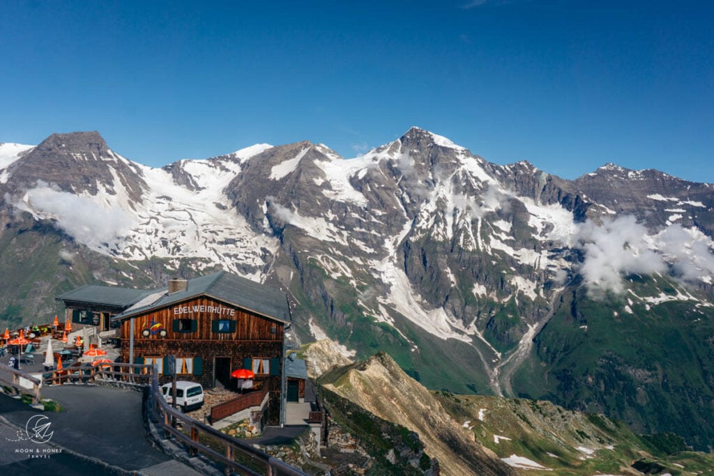
Edelweiss-Spitze (2571 m) is the highest vantage point along the High Alpine Road. The turnoff to Edelweiss Spitze is signed. You’ll find a large parking lot by Restaurant Fuschertörl, but continue driving up the narrow road to Edelweiss-Spitze. Exact Location: Google Maps
Glocknerhaus (2132 m) is the starting point of the must-do Glacier Trail Pasterze. It’s also a great place to have lunch. Exact Location: Google Maps
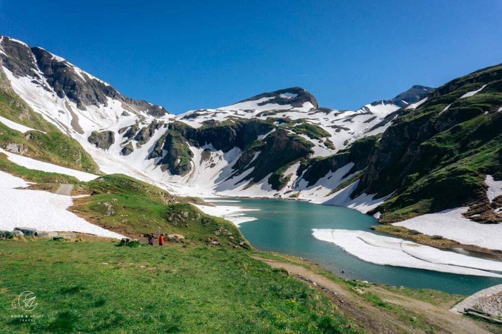
Nassfeld Speicher (2233 m) is a small lake fed by two waterfalls just off the road between the Glocknerhaus and Kaiser Franz Josefs Höhe. Exact Location: Google Maps
Kaiser Franz Josefs Höhe (2369 m) is a lookout point of Grossglockner and rapidly receding Pasterze Glacier. Here, you’ll find a visitor center, Panoramarestaurant Kaiser Franz-Josefs-Höhe, and parking garage. It’s also the starting point for the Gamsgrubenweg. Exact Location: Google Maps
Hiking Trails
Glacier Trail Pasterze Circuit Trail

The Glacier Trail Pasterze (Gletscherweg Pasterze), running from Glocknerhaus to Kaiser-Franz-Josefs-Höhe, is a must-do hike along the Grossglockner High Alpine Road. This well-marked, easy-to-follow circuit takes around three hours to complete.
The route follows the first stage of the Alpe Adria Trail, which begins at Kaiser-Franz-Josefs-Höhe and continues all the way to Heiligenblut. For this hike, however, starting at Glocknerhaus is the better choice; the scenery unfolds beautifully and becomes increasingly dramatic as you approach the foot of Grossglockner.

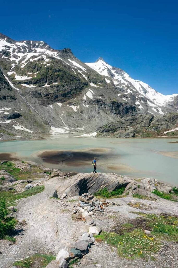
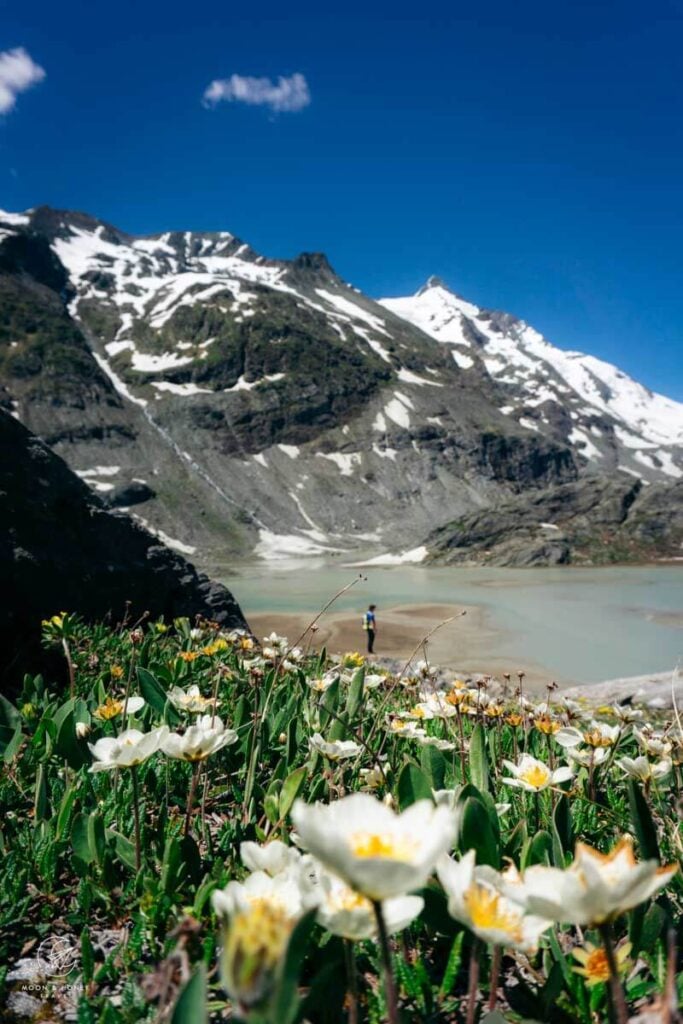
From Glocknerhaus, the trail descends toward the Margaritzenstausee reservoir. It then continues along the water’s edge, crossing two concrete dam walls. The reservoir itself is fed by meltwater from the Pasterze Glacier.
The path then climbs toward Sandersee. From here, you’re rewarded with impressive views of both the Pasterze Glacier and Grossglockner.

Continue the hike all the way up to Kaiser-Franz-Josefs-Höhe. From there, it’s possible to return to Glocknerhaus by bus. However, connections are very limited, with a maximum of about three departures per day, so planning ahead is essential. Inside Glocknerhaus, you’ll find a posted timetable for the regional bus service. It’s worth checking this before starting your hike to make sure you can align your timing with the return options.
Trailhead | Glocknerhaus Kärnten: Google Maps
Distance | 7.8 km circuit
Time Needed | 3 hours
Elevation Gain/Loss | 444 meters
Difficulty | Moderate
Minimum Elevation | 1991 meters
Maximum Elevation | 2370 meters
Route | Glocknerhaus – Margaritzenstausee – Sandersee – Franz-Josefs-Höhe – Pasterzenhaus – Glocknerhaus
Gamsgrubenweg

Starting at Kaiser-Franz-Josefs-Höhe, the Gamsgrubenweg passes through a series of tunnels to the Wasserfallwinkel viewpoint, overlooking the glacier tongue and its cascading meltwater.

In recent years, access has become more restricted due to rockfall risk. The trail is currently only safely maintained up to Tunnel 6. The continuation beyond this point toward Wasserfallwinkel and further in the direction of Oberwalderhütte is no longer part of the regular hiking route and should only be attempted by experienced alpinists with appropriate mountaineering equipment (including a helmet).
Trailhead | Kaiser Franz-Josefs-Höhe: Google Maps
Distance | 5.3 km out-and-back
Time Needed | 1:30 hours
Elevation Gain/Loss | 200 meters
Difficulty | Easy
Minimum Elevation | 2369 meters
Maximum Elevation | 2551 meters
Read Next: Best Hikes in Salzburg
Where to Eat

There are several places to stop for food along the route, including Restaurant Fuschertörl and Edelweisshütte at Edelweiss-Spitze.
Additional stops along the Grossglockner High Alpine Road include Haus Alpine Naturschau, Römerhütte, Restaurant Fuscher Lacke, Restaurant Schöneck, Knappkasa, and Karl-Volkert-Haus.
At Kaiser-Franz-Josefs-Höhe, you’ll also find several dining choices, including Restaurant Kaiser Franz Josef Haus and Freiwandeck.
We ate a delicious lunch at Glocknerhaus after completing the Glacier Trail Pasterze hike.
Großglockner High Alpine Road Hotels

These accommodations are located along the Großglockner High Alpine Road.
3-star Berggasthof Wallackhaus is the best place to stay if you want to experience sunset and sunrise along the Grossglockner route. With its unbeatable location, you can extend your exploration of the area and relish the Hohe Tauern mountains from your hotel room. Breakfast included.
3-star Panoramarestaurant Kaiser Franz-Josefs-Höhe offers comfortable double or twin rooms, which include breakfast on request. You can eat dinner at the on-site restaurant. Located directly at the Franz-Josefs-Höhe, the location of this accommodation could not be better. Great value for money!
All accommodation along the Großglockner Hochalpenstraße.
My Austrian Alps Travel Guides
Hiking:
- Best Day Hikes in Austria
- Best Treks in Austria
- Hut to Hut Hiking in Austria
- How to Visit an Austrian Mountain Hut
Seasonal Guides:
Culture / Folk Festival:
Hotels:


Pin this Image for Future Trip Planning!
Stay Connected:
Connect with us on Pinterest.
Follow us on Instagram.
Like us on Facebook.
Support Us:
If you love reading my content, you can send me a direct donation.


Hello, is there an address that can help me find more information about the hike you mentioned starting Glocknerhaus to Kaiser-Franz-Josefs-Höhe? GPS coordinates? Parking Lot address? Thanks!
Hi Sally,
Glocknerhaus: Gletscherstraße, 6844 Heiligenblut.
You can easily find the location in Google Maps.
Hi, Kati and Sabrina!
thank you for your wonderful website with all the useful info, beautiful pictures and great recommendations. I did go through many of your articles but I still wanted to ask you for an advice.
I’m doing an alta Via 2 on July 8th, prior to that I will do a Hut-To-Hut Traverse Across Tre Cime Nature Park from July 1st to 4th,. But I also have a week in Austria from June 24th to June 30th, and I want to plan another track. I don’t want it to be too easy nor too difficult, because I don’t want to exhaust myself.
If you were to choose one track in Austria for 5-7 days, prior to the tracks I mentioned, which one would it be ?
I was looking at Grossglockner loop, do you think it’s a good track ? Or should I do a Ratikon Hight trail instead? Or maybe Schladming loop? ( or will it be to early for the last track?)
Thank you for your time!
Hi Irena,
We love the Rätikon Alps High Trail. It’s an absolute pleasure to hike.
We haven’t hiked the Grossglockner Loop.
Schladminger Tauern and the other treks we’ve written about are significantly more difficult than the Rätikon Alps trek and Alta Via 1 trek. So as long as you’re up for a bit more technical hiking, I would say go for it! The mountains of Schladming are not as dramatic comparatively, but the lakes along the route are a dream.
happy hiking,
Sabrina